Fichier:Provincia di Lubiana1941-1943.jpg

Taille de cet aperçu : 800 × 551 pixels. Autres résolutions : 320 × 220 pixels | 640 × 441 pixels | 976 × 672 pixels.
Fichier d’origine (976 × 672 pixels, taille du fichier : 204 kio, type MIME : image/jpeg)
Ce fichier et sa description proviennent de Wikimedia Commons.
Description
| Description |
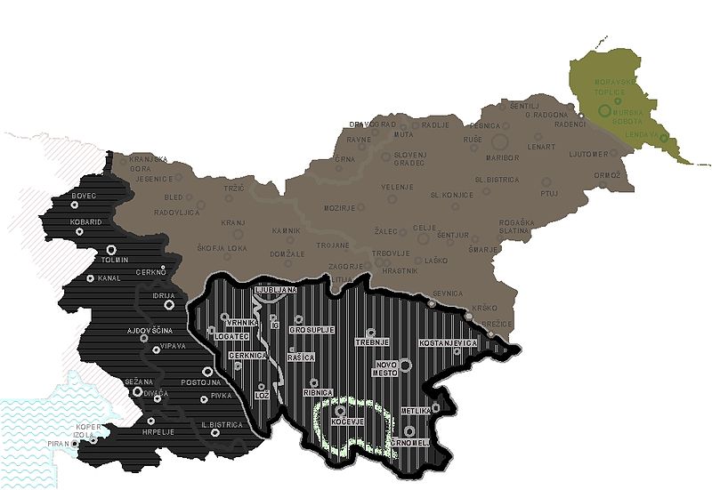
English: The Province of Ljubljana within the borders of present-day Slovenia; showing Slovene territory divided between Nazi Germany, Hungary, and Italy, including the area already annexed by Italy with the Treaty of Rapallo and a silhouette of Gottschee area. The French colored version below is a far superior to this one, and I don't speak French. |
| Date | |
| Source | Travail personnel |
| Auteur | DancingPhilosopher |
| Autres versions |
|

|
Une version vectorielle de cette image existe, dans le format « SVG ». Si elle n’est pas inférieure, elle devrait être utilisée à la place de la présente version pour des affichages en plus grandes dimensions ou nécessitant une meilleure résolution.
File:Provincia di Lubiana1941-1943.jpg → File:Slovenia occupation World War Two-fr.svg
Pour plus d’informations sur les images vectorielles, consultez la page de transition de Commons vers le format SVG. Voir aussi les informations à propos de la manière dont le logiciel MediaWiki gère les images au format SVG. |
 |
Conditions d’utilisation
| Moi, propriétaire des droits d’auteur sur cette œuvre, la place dans le domaine public. Ceci s'applique dans le monde entier. Dans certains pays, ceci peut ne pas être possible ; dans ce cas : J’accorde à toute personne le droit d’utiliser cette œuvre dans n’importe quel but, sans aucune condition, sauf celles requises par la loi. |
Historique du fichier
Cliquer sur une date et heure pour voir le fichier tel qu'il était à ce moment-là.
| Date et heure | Vignette | Dimensions | Utilisateur | Commentaire | |
|---|---|---|---|---|---|
| actuel | 5 septembre 2013 à 16:05 | | 976 × 672 (204 kio) | DancingPhilosopher | Adriatic Sea in blue colored hash |
| 1 février 2013 à 17:54 |  | 976 × 672 (183 kio) | DancingPhilosopher | Province of Ljubljana within the borders of present-day Slovenia, showing Slovene territory divided between Nazi Germany, Hungary, and Italy, including the area already annexed by Italy with the Treaty of Rapallo. | |
| 21 octobre 2010 à 21:03 |  | 779 × 643 (71 kio) | DerBorg | little graphic fix | |
| 16 septembre 2008 à 04:11 |  | 796 × 643 (71 kio) | Spalatino | {{Information |Description={{en|1=Map of the Italian "Provincia di Lubiana", that existed between 1941 and 1943. I have added in green the borders of the german ethnic community of Gotschee (that existed inside Slovenia until 1940).}} |Source=Own work by |
Utilisation du fichier
Les 2 pages suivantes utilisent ce fichier :
Usage global du fichier
Les autres wikis suivants utilisent ce fichier :
- Utilisation sur ar.wikipedia.org
- Utilisation sur bs.wikipedia.org
- Utilisation sur cs.wikipedia.org
- Utilisation sur de.wikipedia.org
- Utilisation sur en.wikipedia.org
- Utilisation sur es.wikipedia.org
- Utilisation sur id.wikipedia.org
- Utilisation sur it.wikipedia.org
- Utilisation sur ja.wikipedia.org
- Utilisation sur mk.wikipedia.org
- Utilisation sur pl.wikipedia.org
- Utilisation sur pt.wikipedia.org
- Utilisation sur rue.wikipedia.org
- Utilisation sur ru.wikipedia.org
- Utilisation sur sh.wikipedia.org
- Utilisation sur sl.wikipedia.org
- Utilisation sur sr.wikipedia.org
- Utilisation sur sv.wikipedia.org
- Utilisation sur tr.wikipedia.org
- Utilisation sur uk.wikipedia.org
- Utilisation sur www.wikidata.org