Fichier:AfricaMap1.jpg
Taille de cet aperçu : 800 × 300 pixels. Autres résolutions : 320 × 120 pixels | 1 202 × 451 pixels.
Fichier d’origine (1 202 × 451 pixels, taille du fichier : 101 kio, type MIME : image/jpeg)
Ce fichier et sa description proviennent de Wikimedia Commons.
| Description |
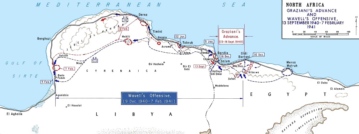
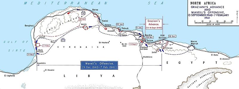
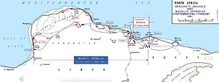
English: Graziani's advance and Wavell's offensive -- en:September 13, en:1940 - en:February 7, en:1941
Français : Avancée de l'armée italienne de Rodolfo Graziani en septembre 1940. |
|||
| Date | Date inconnue, after 1938 | |||
| Source | Older version of Map 34 at http://www.dean.usma.edu/history/web03/atlases/ww2%20europe/WWIIEuropeIndex.html | |||
| Auteur | Department of History at the United States Military Academy | |||
| Autorisation (Réutilisation de ce fichier) |
|


Ce fichier, placé dans le domaine public lors de son importation, a été vérifié par l'administrateur ou l'utilisateur de confiance Jappalang (talk) le 12 juin 2009, qui a confirmé qu'il était dans le domaine public à cette date.
|
Journal des téléversements d’origine
(All user names refer to en.wikipedia)
- 2004-08-20 12:39 GeneralPatton 1202×451×8 (131506 bytes) Graziani's advance and Wavell's offensive -- [[September 13, 1940]] - [[February 7]], [[1941]]
Historique du fichier
Cliquer sur une date et heure pour voir le fichier tel qu'il était à ce moment-là.
| Date et heure | Vignette | Dimensions | Utilisateur | Commentaire | |
|---|---|---|---|---|---|
| actuel | 27 mars 2011 à 15:52 | 1 202 × 451 (101 kio) | Hohum | cleanup | |
| 6 mai 2007 à 15:36 | 1 202 × 451 (128 kio) | Chanueting | {{Information |Description=Graziani's advance and Wavell's offensive -- en:September 13, en:1940 - en:February 7, en:1941 Source: US ARMY License: US Government document. Printed by the Government printing office. Assumed public doma |
Utilisation du fichier
Les 6 pages suivantes utilisent ce fichier :
Usage global du fichier
Les autres wikis suivants utilisent ce fichier :
- Utilisation sur ar.wikipedia.org
- Utilisation sur azb.wikipedia.org
- Utilisation sur bg.wikipedia.org
- Utilisation sur ca.wikipedia.org
- Utilisation sur da.wikipedia.org
- Utilisation sur de.wikipedia.org
- Utilisation sur en.wikipedia.org
- Military history of Italy during World War II
- Richard O'Connor
- Via della Vittoria
- Western Desert campaign
- Beda Fomm
- Military history of Australia during World War II
- Portal:Military history of Australia
- Battle of Beda Fomm
- Maletti Group
- Combeforce
- User:Ian Rose/Draft3
- File talk:AfricaMap1.jpg
- Battle of Sidi Barrani
- Southern Rhodesia in World War II
- Attack on Nibeiwa
- German radio intelligence operations during World War II
- British capture of Tobruk
- Utilisation sur en.wikibooks.org
- Utilisation sur es.wikipedia.org
- Utilisation sur fa.wikipedia.org
- Utilisation sur fi.wikipedia.org
- Utilisation sur gl.wikipedia.org
- Utilisation sur ha.wikipedia.org
Voir davantage sur l’utilisation globale de ce fichier.