Linton Township (comté d'Allamakee, Iowa)
établissement humain, comté d'Allamakee, Iowa, États-Unis
Linton Township est un township, du comté d'Allamakee en Iowa, aux États-Unis[1],[2].
| Linton Township | ||||
| Administration | ||||
|---|---|---|---|---|
| Pays | ||||
| État | ||||
| Comté | Allamakee | |||
| Type de localité | Township | |||
| Code FIPS | 19-92655 | |||
| GNIS | 0468284 | |||
| Démographie | ||||
| Population | 305 hab. () | |||
| Densité | 3,7 hab./km2 | |||
| Géographie | ||||
| Coordonnées | 43° 07′ 36″ nord, 91° 18′ 56″ ouest | |||
| Altitude | 228 m |
|||
| Superficie | 8 172 ha = 81,72 km2 | |||
| · dont terre | 81,72 km2 (100 %) | |||
| · dont eau | 0 km2 (0 %) | |||
| Fuseau horaire | CST (UTC-6) | |||
| Divers | ||||
| Fondation | 1851 | |||
| Localisation | ||||
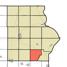
 Carte du comté d'Allamakee. | ||||
| Géolocalisation sur la carte : États-Unis
Géolocalisation sur la carte : États-Unis
Géolocalisation sur la carte : Iowa
| ||||
| modifier |
||||
Il est organisé en 1851[3].
Références modifier
- (en) « Linton Township, Allamakee County, (IA) detailed profile » [« Données sur Linton Township, comté d'Allamakee, Iowa »], sur le site city-data.com (consulté le ).
- (en) « IA - Linton township », sur le site census.gov/ (consulté le ).
- (en) Hancock Ellery M., Past and Present of Allamakee County, Iowa : A Record of Settlement, Organization, Progress and Achievement, vol. 1, S. J. Clarke publishing Company., , p. 227.
Articles connexes modifier
Source de la traduction modifier
- (en) Cet article est partiellement ou en totalité issu de l’article de Wikipédia en anglais intitulé « Linton Township, Allamakee County, Iowa » (voir la liste des auteurs).


