Fichier:The navigation officer on a Boeing 707 aircraft, leaving Rhein Main Air Base, Germany, plots a course using a laptop computer in connection with the Joint Surveillance Target Attack - DPLA - 8fdc872484c1f9d6c0bd01852d1244fb.jpeg

Taille de cet aperçu : 800 × 527 pixels. Autres résolutions : 320 × 211 pixels | 640 × 422 pixels | 1 024 × 675 pixels | 1 499 × 988 pixels.
Fichier d’origine (1 499 × 988 pixels, taille du fichier : 480 kio, type MIME : image/jpeg)
Ce fichier et sa description proviennent de Wikimedia Commons.
Description
| Creator | Department of Defense. American Forces Information Service. Defense Visual Information Center. 1996 | |||||||||||||||||||
| Titre |
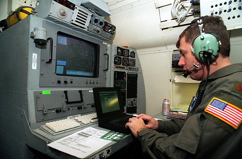
The navigation officer on a Boeing 707 aircraft, leaving Rhein Main Air Base, Germany, plots a course using a laptop computer in connection with the Joint Surveillance Target Attack Radar System (J-STARS). J-STARS is a long range, air-to-ground surveillance and battle management system. When in flight the radar can detect and track more than 120 miles of terrain providing the battle commander with invaluable information about troop movement and position. A 40-foot radome under the forward part of the fuselage houses the phased-array radar antenna. The information is fed to the 17 Army and Air Force operators who have access to the radar data in real-time via on-board large-screen graphics... |
|||||||||||||||||||
| Description |
The original finding aid described this photograph as: [Complete] Scene Caption: The navigation officer on a Boeing 707 aircraft, leaving Rhein Main Air Base, Germany, plots a course using a laptop computer in connection with the Joint Surveillance Target Attack Radar System (J-STARS). J-STARS is a long range, air-to-ground surveillance and battle management system. When in flight the radar can detect and track more than 120 miles of terrain providing the battle commander with invaluable information about troop movement and position. A 40-foot radome under the forward part of the fuselage houses the phased-array radar antenna. The information is fed to the 17 Army and Air Force operators who have access to the radar data in real-time via on-board large-screen graphics consoles. The radar data is simultaneously transmitted via secure data links to the Ground Station Modules (GSM) located throughout the theater for Operation Joint Endeavor. The GSMs for Operation Joint Endeavor are located in Hungary, Italy and Bosnia -Herzegovina. Run solely by the Army, these GSMs are integrated into Echelons Above Corps, Corps, Division, and Brigade to support maneuver, intelligence and fire support systems. Here, after receiving a request from a GSM, the navigation officer plots a course to provide the best coverage to those stations while still covering their original mission. Subject Operation/Series: JOINT ENDEAVOR Country: Deutschland / Germany (DEU) Scene Camera Operator: SGT Larry Aaron (USA) Release Status: Released to Public |
|||||||||||||||||||
| Date | 19 février 1996 | |||||||||||||||||||
| Collection |
|
|||||||||||||||||||
| Source / photographe |
|
|||||||||||||||||||
| Autorisation (Réutilisation de ce fichier) |
|
|||||||||||||||||||
| Standardized rights statement |
|
|||||||||||||||||||


Historique du fichier
Cliquer sur une date et heure pour voir le fichier tel qu'il était à ce moment-là.
| Date et heure | Vignette | Dimensions | Utilisateur | Commentaire | |
|---|---|---|---|---|---|
| actuel | 21 novembre 2020 à 05:59 | | 1 499 × 988 (480 kio) | DPLA bot | Uploading DPLA ID 8fdc872484c1f9d6c0bd01852d1244fb |
Utilisation du fichier
La page suivante utilise ce fichier :