Fichier:Royce-areas-michigan.jpg

Taille de cet aperçu : 515 × 599 pixels. Autres résolutions : 206 × 240 pixels | 412 × 480 pixels | 660 × 768 pixels | 880 × 1 024 pixels | 1 495 × 1 740 pixels.
Fichier d’origine (1 495 × 1 740 pixels, taille du fichier : 511 kio, type MIME : image/jpeg)
Ce fichier et sa description proviennent de Wikimedia Commons.
Description
| Description |
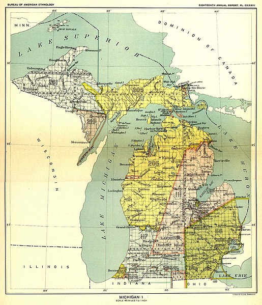
English: This 19th century map, produced by the Smithsonian Institution, depicts the major Native American land cessions that resulted in what is now Michigan.
Français : Carte du 19ème siècle montrant les cessions de territoire des Amérindiens au gouvernement américain dans la région où se trouve aujourd'hui l'état du Michigan. Le territoire en jaune sur la carte a ainsi été cédé aux USA en 1836 lors du traité de Washington. |
| Date | entre 1896 et 1897 |
| Source | United States Serial Set Number 4015 contains the second part of the two-part Eighteenth Annual Report of the Bureau of American Ethnology to the Secretary of the Smithsonian Institution, 1896-1897. Indian Land Cessions in the United States, 1784-1894 United States Serial Set, Number 4015 |
| Auteur | Bureau of American Ethnology |
Conditions d’utilisation
Ce document est dans le domaine public aux États-Unis. Ceci s'applique aux travaux des États-Unis où le copyright a expiré, souvent parce que sa première publication s'est produite avant le 1er janvier 1929. Voir cette page pour davantage d'explication.
|
 | |
 |
Cette image peut ne pas être dans le domaine public en dehors des États-Unis (ceci s'applique particulièrement au Canada, en Chine (pas Hong Kong, Macao, ni Taïwan), en Allemagne ou en Suisse). Le créateur et l'année de la publication sont l'information essentielle et doivent être fournis.
|
Journal des téléversements d’origine
La page de description originale était ici. Tous les noms d'utilisateur qui suivent se rapportent à en.wikipedia.
- 2004-09-29 23:56 Jengod 1495×1740× (522824 bytes) {{PD}} source info in a sec
Historique du fichier
Cliquer sur une date et heure pour voir le fichier tel qu'il était à ce moment-là.
| Date et heure | Vignette | Dimensions | Utilisateur | Commentaire | |
|---|---|---|---|---|---|
| actuel | 11 mai 2009 à 17:13 | | 1 495 × 1 740 (511 kio) | Sylfred1977 | {{Information |Description={{en|This 19th century map, produced by the Smithsonian Institution, depicts the major Native American land cessions that resulted in what is now Michigan. United States Serial Set Number 4015 contains the second part of the two |
Utilisation du fichier
Les 3 pages suivantes utilisent ce fichier :
Usage global du fichier
Les autres wikis suivants utilisent ce fichier :
- Utilisation sur ca.wikipedia.org
- Utilisation sur en.wikipedia.org
- Utilisation sur es.wikipedia.org
- Utilisation sur it.wikipedia.org
- Utilisation sur ja.wikipedia.org