Fichier:John-Tallis-1851-Tibet-Mongolia-and-Manchuria-33621.jpg

Fichier d’origine (4 030 × 3 102 pixels, taille du fichier : 12,64 Mio, type MIME : image/jpeg)
Ce fichier et sa description proviennent de Wikimedia Commons.
Description
| Description |
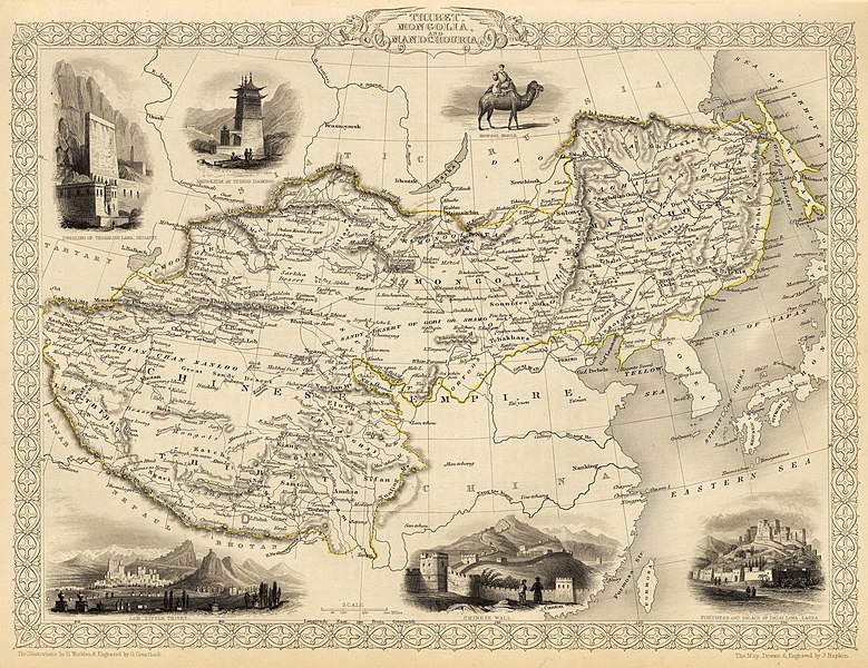
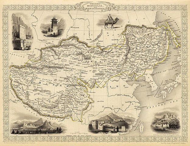
English: Map of the northern and western part of the Chinese Empire - "Thibet, Mongolia, and Mandchouria". The borders are shown as per the 1686 Treaty of Nerchinsk. (They were to be changed drastically in 1858-60, by treaty of Aigun and subsequent agreements). The main Russian center in Transbaikalia is still Nerchinsk, rather than Chita. The outline of Sakhalin Island is already shown fairly correctly, but the body of water separating it from the mainland is still labeled "Gulf of Tartary" (rather than '"Strait).
Français : Carte des parties Nord et Ouest de l'Empire chinois — « Thibet, Mongolie and Mandchourie ». Les frontières sont montrées telles qu'elles étaient définies par le Traité de Nerchinsk de 1686. (Elles allaient être grandement changées en 1858-1860 par le traité d'Aigun et les accords suivants). Le principal centre russe en Transbaïkalie est encore Nerchinsk, plutôt que Chita. Le contour de l'île Sakhaline est déjà décrit très correctement, mais l'étendue d'eau la séparant du continent est encore qualifiée de « golfe de Tartarie » (plutôt que « détroit »).
中文:中国皇国,北部和西部。 |
| Date | |
| Source | John Tallis' atlas of the world. Reproduced at http://www.davidrumsey.com/luna/servlet/detail/RUMSEY~8~1~821~60126:Thibet,-Mongolia,-and-Mandchouria-- (the last version uploaded is from there), http://www.jpmaps.co.uk/mapimages/originals/33621.jpg , and elsewhere |
| Auteur | Martin, R.M.; Tallis, J. & F. The staff of John Tallis: The Illustrations by H. Winkles & Engraved by G. Greatbach. The Map Drawn & Engraved by J. Rapkin. |
| Autres versions | Œuvres dérivées de ce fichier : John-Tallis-1851-Tibet-Mongolia-and-Manchuria-NE.jpg |
Conditions d’utilisation
|
Cette œuvre est également dans le domaine public dans tous les pays pour lesquels le droit d’auteur a une durée de vie de 70 ans ou moins après la mort de l’auteur.
| |
| Ce fichier a été identifié comme étant exempt de restrictions connues liées au droit d’auteur, y compris tous les droits connexes et voisins. | |
Historique du fichier
Cliquer sur une date et heure pour voir le fichier tel qu'il était à ce moment-là.
| Date et heure | Vignette | Dimensions | Utilisateur | Commentaire | |
|---|---|---|---|---|---|
| actuel | 28 février 2016 à 22:51 | | 4 030 × 3 102 (12,64 Mio) | Centpacrr | Crop |
| 7 décembre 2009 à 04:26 |  | 4 700 × 3 750 (4,07 Mio) | Vmenkov | better resolution, as available from http://www.davidrumsey.com/luna/servlet/detail/RUMSEY~8~1~821~60126:Thibet,-Mongolia,-and-Mandchouria-- | |
| 7 décembre 2009 à 03:38 |  | 1 289 × 989 (386 kio) | Vmenkov | {{Information |Description={{en|1=Map of the northern and western part of the Chinese Empire - "Thibet, Mongolia, and Mandchouria". The borders are shows as per the 1858 treaty of Aigun. The main Russian center in Transbaikalia is still Nerchinsk, rather |
Utilisation du fichier
Les 7 pages suivantes utilisent ce fichier :
Usage global du fichier
Les autres wikis suivants utilisent ce fichier :
- Utilisation sur ar.wikipedia.org
- Utilisation sur en.wikipedia.org
- Utilisation sur hr.wikipedia.org
- Utilisation sur mn.wikipedia.org
- Utilisation sur sh.wikipedia.org
- Utilisation sur vi.wikipedia.org