Fichier:Grossdeutsches Reich NS Administration 1944.png
Fichier d’origine (2 615 × 2 030 pixels, taille du fichier : 250 kio, type MIME : image/png)
Ce fichier et sa description proviennent de Wikimedia Commons.
Description
| Description |
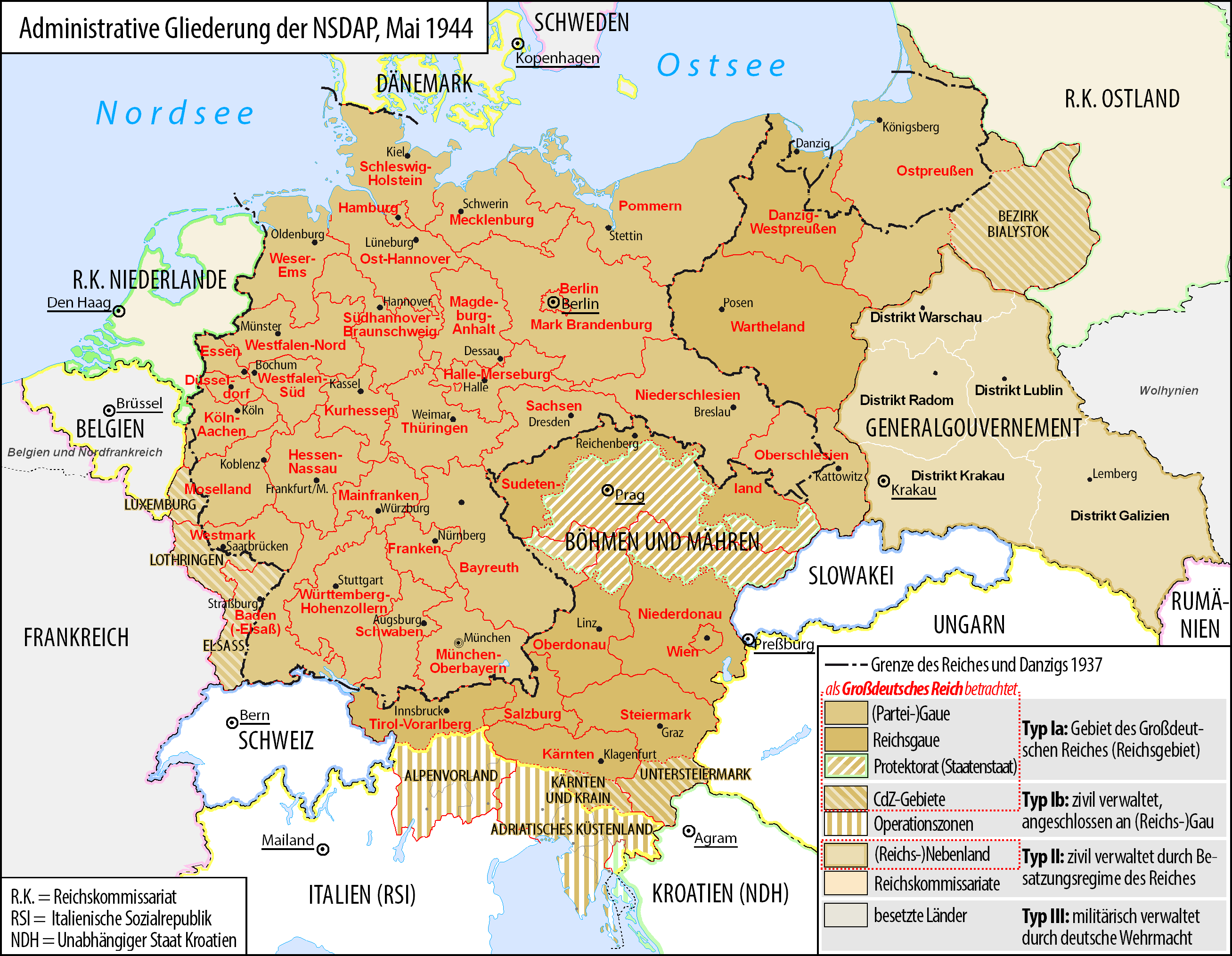
Deutsch: Karte der administrativen Gliederung des Großdeutschen Reiches durch die NSDAP 1944.
English: Map of the administrative division of the Greater German Reich ("Großdeutsches Reich"/"Großdeutschland"/"Greater German Empire"/"Greater Germany") by the NSDAP 1944 (in German).
Polski: Mapa Wielkiej Rzeszy Niemieckiej (1944) |
||
| Date | |||
| Source | Travail personnel | ||
| Auteur | Bennet Schulte | ||
| Autorisation (Réutilisation de ce fichier) |
|
||
| Autres versions |
|


Conditions d’utilisation
- Vous êtes libre :
- de partager – de copier, distribuer et transmettre cette œuvre
- d’adapter – de modifier cette œuvre
- Sous les conditions suivantes :
- paternité – Vous devez donner les informations appropriées concernant l'auteur, fournir un lien vers la licence et indiquer si des modifications ont été faites. Vous pouvez faire cela par tout moyen raisonnable, mais en aucune façon suggérant que l’auteur vous soutient ou approuve l’utilisation que vous en faites.
- partage à l’identique – Si vous modifiez, transformez, ou vous basez sur cette œuvre, vous devez distribuer votre contribution sous la même licence ou une licence compatible avec celle de l’original.

|
Vous avez la permission de copier, distribuer et modifier ce document selon les termes de la GNU Free Documentation License version 1.2 ou toute version ultérieure publiée par la Free Software Foundation, sans sections inaltérables, sans texte de première page de couverture et sans texte de dernière page de couverture. Un exemplaire de la licence est inclus dans la section intitulée GNU Free Documentation License. |
Historique du fichier
Cliquer sur une date et heure pour voir le fichier tel qu'il était à ce moment-là.
| Date et heure | Vignette | Dimensions | Utilisateur | Commentaire | |
|---|---|---|---|---|---|
| actuel | 3 juin 2017 à 07:23 | | 2 615 × 2 030 (250 kio) | Exec | auf vielfachen Wunsch wurden die zum Zeitpunkt der Darstellung existierenden militärisch verwalteten Gebiete "Wolhynien" (Rest von RK Ukraine) sowie "Belgien und Nordfrankreich" beschriftet und abgegrenzt wenn abweichend von Staatsgrenzen |
| 4 février 2016 à 02:26 |  | 2 615 × 2 030 (344 kio) | Exec | Reverted to version as of 10:37, 11 September 2015 (UTC): thematic content don't include military administative units, see https://commons.wikimedia.org/wiki/File_talk:Greater_German_Reich_NS_Administration_1944.png#Problems_with_the_map | |
| 6 décembre 2015 à 17:04 |  | 2 607 × 2 022 (579 kio) | Braganza | Reverted to version as of 22:32, 7 July 2014 (UTC) | |
| 11 septembre 2015 à 12:37 |  | 2 615 × 2 030 (344 kio) | RokerHRO | optipng -i0 -zc1-9 -zm1-9 -zs0-3 -f0-5 -i0 → 35.13% decrease | |
| 27 juin 2015 à 11:32 |  | 2 615 × 2 030 (530 kio) | Exec | - clearified phrase for dotted line (statt "dargestellt als", "als betrachtet" | |
| 27 juin 2015 à 11:23 |  | 2 616 × 2 029 (530 kio) | Exec | - added subdevision of the Operationszonen - fixed explanation of red dotted line (visualisation in cartographic materials as Großdeutsches Reich) and exclude Operationszonen | |
| 3 avril 2015 à 02:18 |  | 2 607 × 2 022 (231 kio) | Exec | Reverted to version as of 21:17, 17 July 2014 because no fixes are identified but some black objects are switched to grey with out logic and benefit.undaries to grey | |
| 29 mars 2015 à 09:08 |  | 2 607 × 2 022 (345 kio) | DIREKTOR | Small fix. | |
| 17 juillet 2014 à 23:17 |  | 2 607 × 2 022 (231 kio) | Execger | Boundaries of millitary administration is not part of the thematic content. | |
| 8 juillet 2014 à 00:32 |  | 2 607 × 2 022 (579 kio) | Victor falk~commonswiki | belgien und nordfrankreich |
Utilisation du fichier
Les 8 pages suivantes utilisent ce fichier :
Usage global du fichier
Les autres wikis suivants utilisent ce fichier :
- Utilisation sur cs.wikipedia.org
- Utilisation sur da.wikipedia.org
- Utilisation sur de.wikipedia.org
- Gau
- Geschichte Österreichs
- Generalgouvernement
- Beneš-Dekrete
- Reichsstatthalter
- Reichsgau
- Danzig-Westpreußen
- Deutsche Frage
- Geschichte der Steiermark
- Kriegsschauplatz Mittelmeerraum
- NS-Staat
- Diskussion:Liste der größten deutschen Städte
- Liste der Wappen in Deutschland
- Geschichte Niederösterreichs
- Deutschland
- Operationszone Adriatisches Küstenland
- Diskussion:Deutschland/Archiv/2
- Geschichte Oberösterreichs
- Ostmarkgesetz
- Portal Diskussion:Nationalsozialismus/Archiv/2010
- Liste der Postleitregionen in Deutschland
- Wikipedia:Kartenwerkstatt/Archiv/Zurückgewiesene und zurückgestellte Aufträge 2012
- Portal Diskussion:Nationalsozialismus/Archiv/2014
- Diskussion:Uschi Nerke
- Wikipedia:Redaktion Geschichte/Archiv/2023/Feb
- Utilisation sur frr.wikipedia.org
- Utilisation sur fr.wiktionary.org
- Utilisation sur gl.wikipedia.org
- Utilisation sur hak.wikipedia.org
- Utilisation sur he.wikipedia.org
- Utilisation sur it.wikipedia.org
- Utilisation sur ja.wikipedia.org
- Utilisation sur lb.wikipedia.org
- Utilisation sur lld.wikipedia.org
- Utilisation sur lt.wikipedia.org
- Utilisation sur nl.wikipedia.org
- Utilisation sur no.wikipedia.org
Voir davantage sur l’utilisation globale de ce fichier.