Fichier:Georgia topographic map-fr.svg

Taille de cet aperçu PNG pour ce fichier SVG : 707 × 385 pixels. Autres résolutions : 320 × 174 pixels | 640 × 349 pixels | 1 024 × 558 pixels | 1 280 × 697 pixels | 2 560 × 1 394 pixels.
Fichier d’origine (Fichier SVG, nominalement de 707 × 385 pixels, taille : 3,52 Mio)
Ce fichier et sa description proviennent de Wikimedia Commons.
Description
| Description |
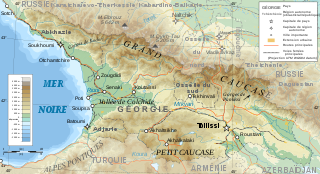
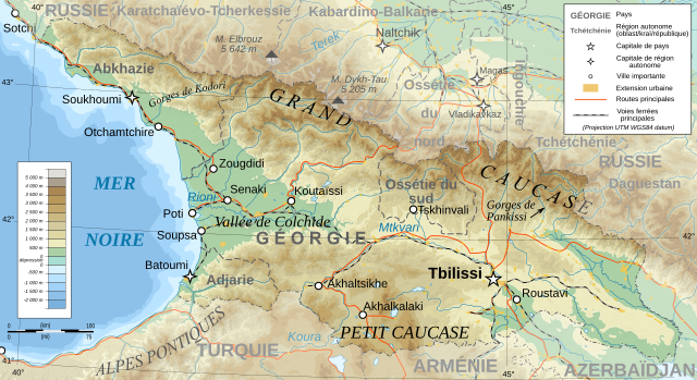
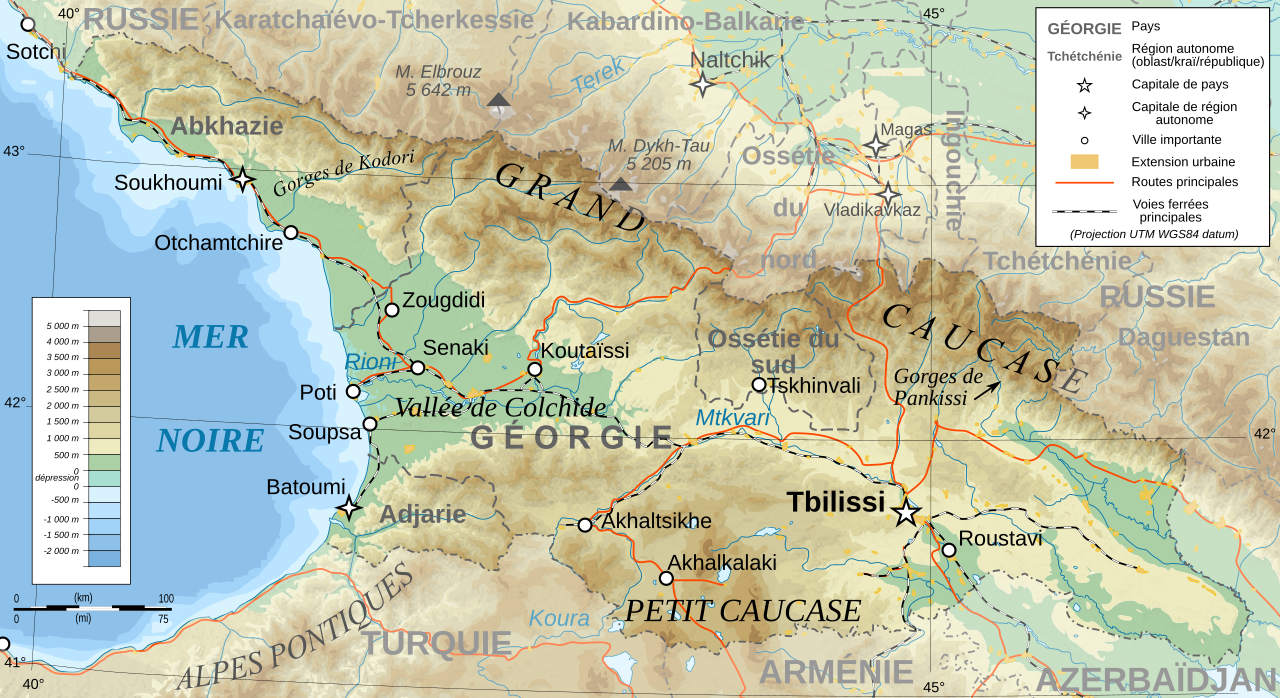
Deutsch: Topographische Karte von Georgien, französische Version English: Topographic map in French of Georgia Français : Carte topographique en français de la Géorgie |
| Date | |
| Source |
English: Own work ; Topographic data from the NASA Shuttle Radar Topography Mission (SRTM3 v.2) (public domain) edited with 3DEM, reprojected in UTM with GDAL (GDAL), and vectorized with Inkscape ; UTM projection ; WGS84 datum ; shaded relief (composite image of N-W, W and N lightning positions) ; Reference used for the additional data : * Rivers, cities, railroads, routes, bathymetry : Demis add-on for World Wind (see the approval e-mail and the Demis forum) ; * Borders and coast : World data bank II ; Approximate scale of topographic data : 1:1,463,000 ; Note : The shaded relief is a raster image embedded in the SVG file. Français : Création personnelle ; Données topographiques de la NASA Shuttle Radar Topography Mission (SRTM3 v.2) (domaine public) éditées avec 3DEM, reprojetées en UTM avec GDAL et vectorisées avec Inkscape ; projection UTM ; WGS84 datum ; relief ombré (image composite d'éclairages du N-O, O et N) ; Références utilisées pour les données complémentaires : * Rivières, villes, chemins de fers, routes, bathymétrie : Demis add-on for World Wind (cf. l'e-mail d'approbation de Demis et le Demis forum) ; * Frontières et côtes : World data bank II ; Échelle approximative des données topographiques : 1:1 463 000 ; Note : Le relief ombré est une image bitmap embarquée dans le fichier SVG. |
| Auteur | Bourrichon - fr:Bourrichon |
| Autorisation (Réutilisation de ce fichier) |
GFDL / Attribution and Share-Alike required |
| Autres versions |
Œuvres dérivées de ce fichier : Georgia topographic map-blanked.svg
|


|
Ce fichier SVG contient du texte encapsulé pouvant facilement être traduit dans votre langue en utilisant n'importe quel éditeur de fichier SVG ou de texte, ou par l'outil de traduction de fichiers SVG. Pour plus d'informations, voir : A propos de la traduction des fichiers SVG. |
Conditions d’utilisation
Moi, en tant que détenteur des droits d’auteur sur cette œuvre, je la publie sous les licences suivantes :

|
Vous avez la permission de copier, distribuer et modifier ce document selon les termes de la GNU Free Documentation License version 1.2 ou toute version ultérieure publiée par la Free Software Foundation, sans sections inaltérables, sans texte de première page de couverture et sans texte de dernière page de couverture. Un exemplaire de la licence est inclus dans la section intitulée GNU Free Documentation License. |
This file is licensed under the Creative Commons Attribution-Share Alike Attribution-Share Alike 4.0 International, 3.0 Unported, 2.5 Generic, 2.0 Generic and 1.0 Generic license.
- Vous êtes libre :
- de partager – de copier, distribuer et transmettre cette œuvre
- d’adapter – de modifier cette œuvre
- Sous les conditions suivantes :
- paternité – Vous devez donner les informations appropriées concernant l'auteur, fournir un lien vers la licence et indiquer si des modifications ont été faites. Vous pouvez faire cela par tout moyen raisonnable, mais en aucune façon suggérant que l’auteur vous soutient ou approuve l’utilisation que vous en faites.
- partage à l’identique – Si vous modifiez, transformez, ou vous basez sur cette œuvre, vous devez distribuer votre contribution sous la même licence ou une licence compatible avec celle de l’original.
Vous pouvez choisir l’une de ces licences.
Historique du fichier
Cliquer sur une date et heure pour voir le fichier tel qu'il était à ce moment-là.
| Date et heure | Vignette | Dimensions | Utilisateur | Commentaire | |
|---|---|---|---|---|---|
| actuel | 13 janvier 2020 à 16:57 | | 707 × 385 (3,52 Mio) | Takhirgeran Umar | clarification |
| 30 mars 2009 à 23:43 |  | 707 × 385 (3,52 Mio) | Bourrichon | +Daguestan | |
| 13 mars 2009 à 20:09 |  | 707 × 385 (3,52 Mio) | Bourrichon | + longitude | |
| 13 mars 2009 à 20:01 |  | 707 × 385 (3,52 Mio) | Bourrichon | -Iran | |
| 13 mars 2009 à 19:38 |  | 707 × 385 (4,55 Mio) | Bourrichon | + Gorges | |
| 13 mars 2009 à 19:32 |  | 707 × 385 (4,52 Mio) | Bourrichon | == Summary == {{Information |Description={{de|Topographische Karte von Georgien, französische Version}}{{en|Topographic map in French of Georgia}}{{fr|Carte topographique en français de la [[:fr:Géorgie (pays)|Géorgie] |
Utilisation du fichier
Les 7 pages suivantes utilisent ce fichier :
- Géographie de la Géorgie
- Géorgie (pays)
- Liste des villes jumelées de Géorgie
- Wikipédia:Atelier graphique/Cartes/Archives/Demandes mises en sommeil/Europe
- Wikipédia:Atelier graphique/Cartes/Archives/avril 2009
- Wikipédia:Atelier graphique/Cartes/Archives/mars 2009
- Projet:Cartographie/Cartes standards/Pays
Usage global du fichier
Les autres wikis suivants utilisent ce fichier :