Fichier:East Prussia 1923-1939 map-fr.svg

Taille de cet aperçu PNG pour ce fichier SVG : 651 × 600 pixels. Autres résolutions : 261 × 240 pixels | 521 × 480 pixels | 834 × 768 pixels | 1 111 × 1 024 pixels | 2 223 × 2 048 pixels | 865 × 797 pixels.
Fichier d’origine (Fichier SVG, nominalement de 865 × 797 pixels, taille : 202 kio)
Ce fichier et sa description proviennent de Wikimedia Commons.
Description
| Description |
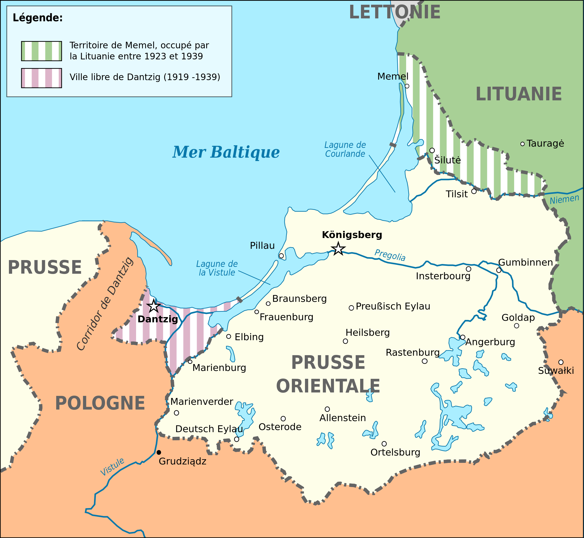
Deutsch: Karte von Ostpreußen 1923-1939. English: Map of Germany's province of East Prussia from 1923 to 1939, with Memelland occupied by Lithuania since 1923. Français : Carte de la province allemande de Prusse-Orientale entre 1923 et 1939, montrant la zone de Memel occupée par la Lituanie depuis 1923. Magyar: Kelet-Poroszország térképe 1923-1939 között. |
||||
| Date | (UTC) | ||||
| Source |
Ce fichier est dérivé de : East Prussia 1939.JPG:  |
||||
| Auteur |
|
||||
| Autres versions |
[]
| ||||
| SVG | W3C-validity not checked. Cette image vectorielle non W3C-spécifiée a été créée avec Inkscape .
|
||||
| Graphic Lab |


| Position de l'objet | | Voir cet endroit et d’autres images sur : OpenStreetMap |
|---|
Conditions d’utilisation
Moi, en tant que détenteur des droits d’auteur sur cette œuvre, je la publie sous la licence suivante :
Ce fichier est disponible selon les termes de la licence Creative Commons Attribution – Partage dans les Mêmes Conditions 3.0 (non transposée).
- Vous êtes libre :
- de partager – de copier, distribuer et transmettre cette œuvre
- d’adapter – de modifier cette œuvre
- Sous les conditions suivantes :
- paternité – Vous devez donner les informations appropriées concernant l'auteur, fournir un lien vers la licence et indiquer si des modifications ont été faites. Vous pouvez faire cela par tout moyen raisonnable, mais en aucune façon suggérant que l’auteur vous soutient ou approuve l’utilisation que vous en faites.
- partage à l’identique – Si vous modifiez, transformez, ou vous basez sur cette œuvre, vous devez distribuer votre contribution sous la même licence ou une licence compatible avec celle de l’original.
Journal des téléversements d’origine
This image is a derivative work of the following images:
- File:East_Prussia_1939.JPG licensed with Cc-by-sa-3.0-migrated, GFDL
- 2008-03-24T22:23:30Z Renata3 752x808 (95143 Bytes) did not crop properly
- 2008-03-24T20:41:51Z Renata3 824x818 (96055 Bytes) cropped white space
- 2006-12-22T22:30:28Z Electionworld 824x818 (303157 Bytes) {{ew|en|Schwartz und Weiss}} East Prussia 1939 {{GFDL}} [[Category:Maps of East Prussia]] [[Category:Maps of the history of Poland]] [[Category:Maps of the history of Russia]] [[Category:Maps of the history of Germany]] [[Cat
Téléversé avec derivativeFX
Historique du fichier
Cliquer sur une date et heure pour voir le fichier tel qu'il était à ce moment-là.
| Date et heure | Vignette | Dimensions | Utilisateur | Commentaire | |
|---|---|---|---|---|---|
| actuel | 13 octobre 2022 à 22:09 | | 865 × 797 (202 kio) | Ispanas | File uploaded using svgtranslate tool (https://svgtranslate.toolforge.org/). Added translation for lt. |
| 13 juin 2020 à 15:53 |  | 865 × 797 (170 kio) | Nk | File uploaded using svgtranslate tool (https://svgtranslate.toolforge.org/). Added translation for bg. | |
| 17 avril 2020 à 11:53 |  | 865 × 797 (127 kio) | Flappiefh | Baltiisk was named Pillau before 1946. | |
| 26 mai 2014 à 15:12 |  | 865 × 797 (127 kio) | Sémhur | Valid SVG | |
| 4 septembre 2012 à 16:40 |  | 865 × 797 (127 kio) | Sémhur | == {{int:filedesc}} == {{Information |Description={{Multilingual description |en= Map of Germany's province of en:East Prussia from 1923 to 1939, with Memelland occupied by Lithuania since 1923 |fr= Carte de la province allemande de [[:fr:Prusse-... |
Utilisation du fichier
Les 5 pages suivantes utilisent ce fichier :
Usage global du fichier
Les autres wikis suivants utilisent ce fichier :
- Utilisation sur bg.wikipedia.org
- Utilisation sur ko.wikipedia.org
- Utilisation sur lt.wikipedia.org
- Utilisation sur www.wikidata.org