Fichier:1818 Pinkerton Map of Asia - Geographicus - Asia-pinkerton-1818.jpg
Taille de cet aperçu : 800 × 587 pixels. Autres résolutions : 320 × 235 pixels | 640 × 470 pixels | 1 024 × 752 pixels | 1 280 × 940 pixels | 2 560 × 1 879 pixels | 6 000 × 4 404 pixels.
Fichier d’origine (6 000 × 4 404 pixels, taille du fichier : 8,73 Mio, type MIME : image/jpeg)
Ce fichier et sa description proviennent de Wikimedia Commons.
Description
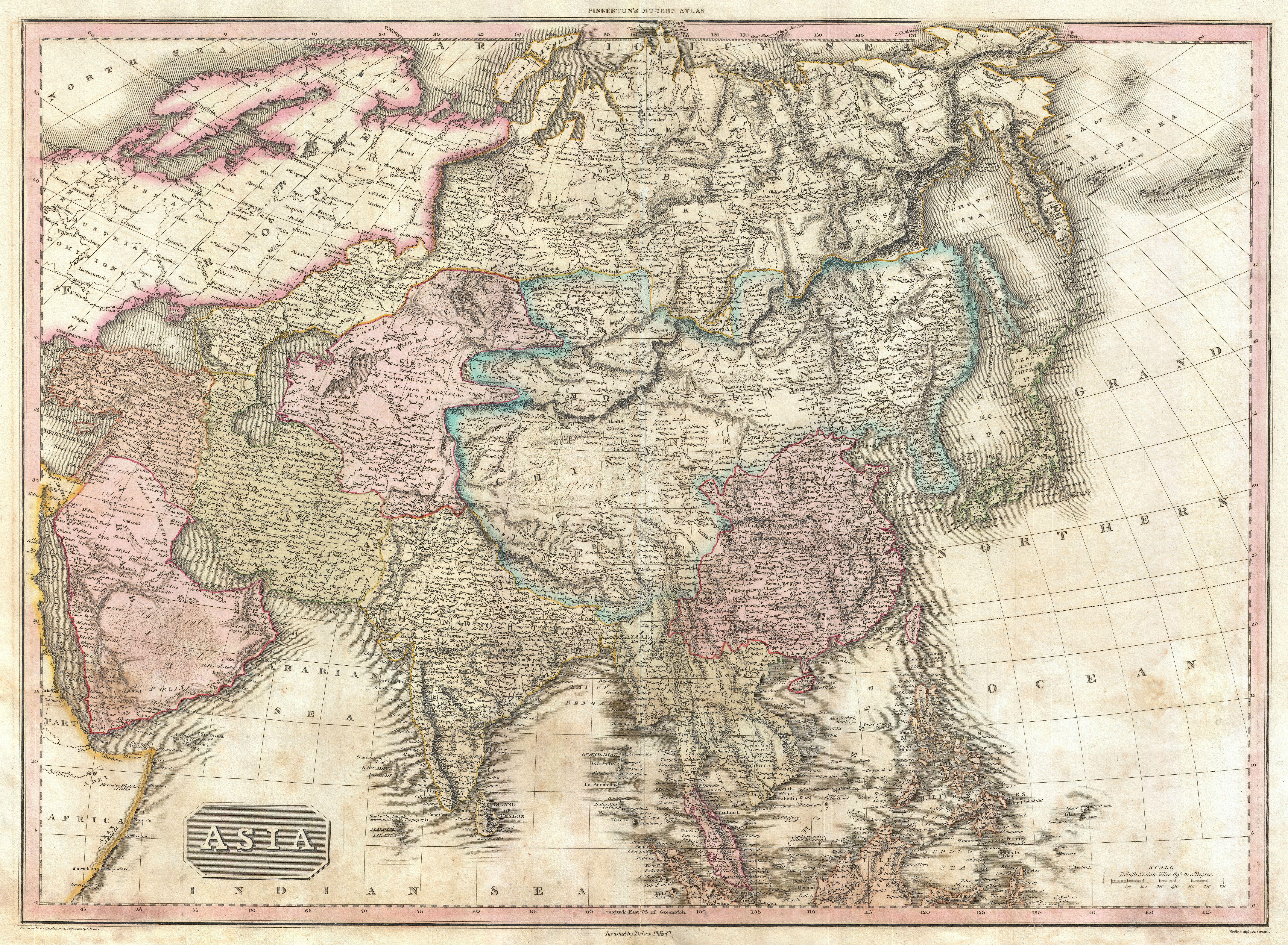
| John Pinkerton : Asia.
( |
|||||||||||||||||||||
|---|---|---|---|---|---|---|---|---|---|---|---|---|---|---|---|---|---|---|---|---|---|
| Artiste |
|
||||||||||||||||||||
| Titre |
Asia. |
||||||||||||||||||||
| Description |
English: This is John Pinkerton's stunning 1818 map of Asia. Covers from the Mediterranean to the Aleutian Islands and from the Arctic to the Equator. This beautifully rendered map is truly a masterpiece of engraving, with mountain ranges, lakes, deserts, and rivers excited with such precision that the result appears almost three dimensional. Pinkerton injections astounding detail throughout with countless towns, cities, geographical features, rivers, islands and bodies of water noted. In desert regions fresh water sources are noted. In the seas certain shoals and undersea are included. In China and Manchuria the Great Wall appears. Singapore islands is shown but not specifically named. The Liakhov Islands, in northern Siberia, which some believed to be entirely composed of fossil mammoth ivory, are noted as Shore Discovered by Herders. All in all, one of the most remarkable maps of Asia to appear in the 19th century. Drawn by L. Herbert and engraved by Samuel Neele under the direction of John Pinkerton. This map was issued in the scarce American edition of Pinkerton’s Modern Atlas, published by Thomas Dobson & Co. of Philadelphia in 1818. |
||||||||||||||||||||
| Date | 1818 (undated) | ||||||||||||||||||||
| Dimensions | hauteur : 21 pouces (53,3 cm) ; largeur : 28 pouces (71,1 cm) | ||||||||||||||||||||
| Numéro d’inventaire |
liens Geographicus : Asia-pinkerton-1818 |
||||||||||||||||||||
| Source / photographe |
Pinkerton, J., A Modern Atlas, from the Lates and Best Authorities, Exhibiting the Various Divisions of the World with its chief Empires, Kingdoms, and States; in Sixty Maps, carefully reduced from the Larges and Most Authentic Sources. 1818, Philadelphia, Thomas Dobson Edition.
|
||||||||||||||||||||
| Autorisation (Réutilisation de ce fichier) |
|
||||||||||||||||||||

Historique du fichier
Cliquer sur une date et heure pour voir le fichier tel qu'il était à ce moment-là.
| Date et heure | Vignette | Dimensions | Utilisateur | Commentaire | |
|---|---|---|---|---|---|
| actuel | 24 mars 2011 à 00:26 | | 6 000 × 4 404 (8,73 Mio) | BotMultichillT | {{subst:User:Multichill/Geographicus |link=http://www.geographicus.com/P/AntiqueMap/Asia-pinkerton-1818 |product_name=1818 Pinkerton Map of Asia |map_title=Asia. |description=This is John Pinkerton's stunning 1818 map of Asia. Covers from the Mediterran |
Utilisation du fichier
Les 2 pages suivantes utilisent ce fichier :