Amphoe Fang
| Fang ฝาง | |
| Administration | |
|---|---|
| Pays | |
| Province | Chiang Mai |
| Tambon | 8 |
| Muban | 128 |
| Démographie | |
| Population | 121 033 hab. (2005) |
| Densité | 136 hab./km2 |
| Géographie | |
| Coordonnées | 19° 55′ 08″ nord, 99° 12′ 49″ est |
| Superficie | 88 816,4 ha = 888,164 km2 |
| Localisation | |
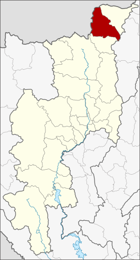
 Localisation du district. | |
| modifier |
|
Fang (ฝาง) est un district (amphoe) situé dans la province de Chiang Mai, dans le nord de la Thaïlande. Il est frontalier de la Birmanie (État Shan).
Le district est divisé en 8 sous-districts (tambon) et 128 villages (muban). Il comprenait 121 033 habitants en 2005.
Histoire modifier
Si l'on en croit la chronique de Yonok, le Mueang (cité) de Fang fut fondé en 641 par le roi Lawa Changkarat. Plus tard, le roi Mengrai le Grand régna depuis Fang pendant un an, en 1268, avant de fonder successivement Wiang Kum Kam et Chiang Mai[1]. Il semble que Mengrai ait utilisé Fang comme base pour attaquer Hariphunchai (l'actuelle Lamphun)[2].
En 1910, Mueang Fang fut subordonnée à Chiang Rai et renommé district de Mueang Fang[3]. En 1925, il fut réattribué à Chiang Mai[4]. En 1938, le mot Mueang, désormais réservé aux capitales de provinces, fut retiré de son nom[5].
Notes et références modifier
- The Chiang Mai Chronicle 2nd Edition, tr. David K. Wyatt and Aroonrut Wichienkeeo, Chinag Mai: Silkworm Books, 1998, p18 (ISBN 9789747100624)
- Ongsakul, Sarassawadee, History of Lan Na, trans. Chitraporn Tanratanakul, Chian Mai: Silkworm Books, Thai text 2001, English text 2005, p.55 (ISBN 9789749575840)
- (th) « ประกาศกระทรวงมหาดไทย », Royal Gazette, vol. 27, no 0 ง, , p. 426–427 (lire en ligne)
- (th) « ประกาศกระทรวงมหาดไทย เรื่อง โอนอำเภอเมืองฝาง จังหวัดเชียงรายไปขึ้นจังหวัดเชียงใหม่ », Royal Gazette, vol. 42, no 0 ง, , p. 203 (lire en ligne)
- (th) « พระราชกฤษฎีกาเปลี่ยนนามจังหวัด และอำเภอบางแห่ง พุทธศักราช ๒๔๘๑ », Royal Gazette, vol. 55, no 0 ก, , p. 658–666 (lire en ligne)
- (en) Cet article est partiellement ou en totalité issu de l’article de Wikipédia en anglais intitulé « Fang District » (voir la liste des auteurs).