Fichier:Zagrebački zbor - entrance to a concentration camp.jpg
Zagrebački_zbor_-_entrance_to_a_concentration_camp.jpg (379 × 400 pixels, taille du fichier : 44 kio, type MIME : image/jpeg)
Ce fichier et sa description proviennent de Wikimedia Commons.
Description
| Description |
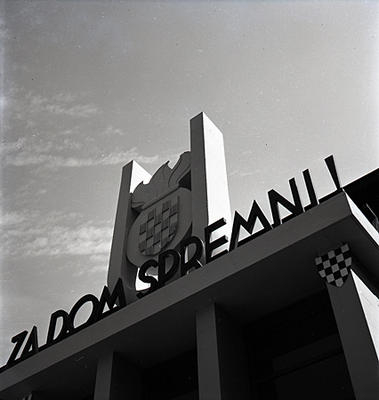
English: Ustasha coat of arms on a building at Zagrebacki Zbor, 1942. "Za dom spremni!" written below is a ustasha battle cry that means "for the homeland ready!" as in ready to do battle for the homeland. |
| Date | |
| Source | http://www.ww2incolor.com/other/Zagrebacki-zbor.html |
| Auteur | anonimus |
| Lieu de la prise de vue | | Voir cet endroit et d’autres images sur : OpenStreetMap |
|---|
Conditions d’utilisation
This Croatian work is in the public domain because its copyright expired pursuant to the Yugoslav Copyright Act of 1978 and the succeeding Croatian Copyright Act of 1991 (NN 53/91 and 58/93), which provided for copyright term of the life of the author plus fifty years, respectively 25 years for photograph or a work of applied art (details). This applies to works already in the public domain on or before July 27th, 1999, when the law was changed.
The work meets one of the following criteria:
A source should be included so that the status can be verified. Note that other works enter the public domain 70 years after the author's death or 70 years after publication if the work was published anonymously. If this is the case please use {{PD-old-70}}.
|
 |
Historique du fichier
Cliquer sur une date et heure pour voir le fichier tel qu'il était à ce moment-là.
| Date et heure | Vignette | Dimensions | Utilisateur | Commentaire | |
|---|---|---|---|---|---|
| actuel | 20 février 2014 à 10:58 | | 379 × 400 (44 kio) | DobarSkroz | User created page with UploadWizard |
Utilisation du fichier
Les 2 pages suivantes utilisent ce fichier :
Usage global du fichier
Les autres wikis suivants utilisent ce fichier :
- Utilisation sur ar.wikipedia.org
- Utilisation sur de.wikipedia.org
- Utilisation sur el.wikipedia.org
- Utilisation sur en.wikipedia.org
- Utilisation sur hr.wikipedia.org
- Utilisation sur id.wikipedia.org
- Utilisation sur it.wikipedia.org
- Utilisation sur pl.wikipedia.org
- Utilisation sur pt.wikipedia.org
- Utilisation sur ru.wikipedia.org
- Utilisation sur sh.wikipedia.org
- Utilisation sur sr.wikipedia.org
- Utilisation sur tr.wikipedia.org
- Utilisation sur uk.wikipedia.org
- Utilisation sur www.wikidata.org