Fichier:World GHI Solar-resource-map GlobalSolarAtlas World-Bank-Esmap-Solargis.png
Fichier d’origine (1 889 × 1 122 pixels, taille du fichier : 1,51 Mio, type MIME : image/png)
Ce fichier et sa description proviennent de Wikimedia Commons.
Description
| Description |
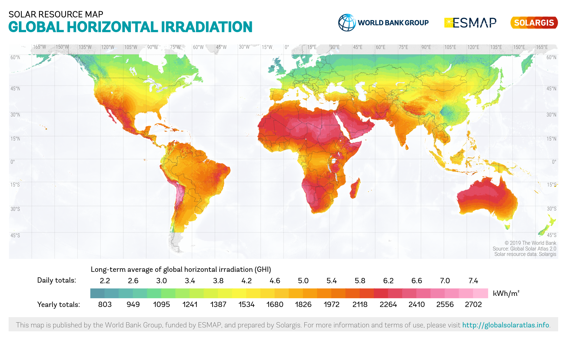
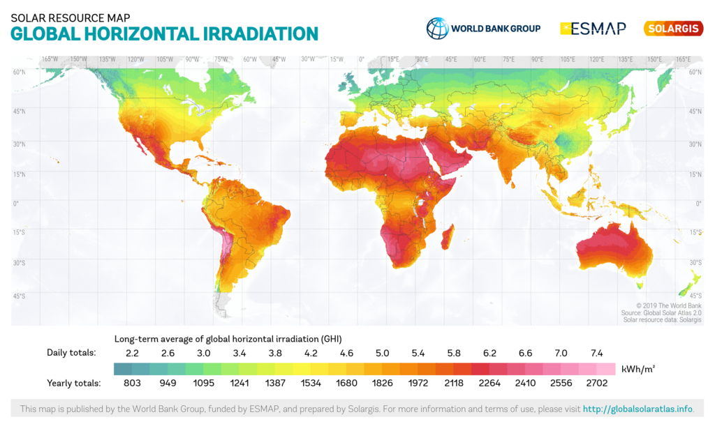
English: Solar resource: GLOBAL HORIZONTAL IRRADIATION (GHI) - this solar resource map provides a summary of the estimated solar energy available for power generation and other energy applications. It represents the average daily/yearly totals of global horizontal irradiation (GHI) covering a period from 1994/1999/2007 (depending on the region) to 2018. The underlying solar resource database is calculated by the Solargis model from atmospheric and satellite data with 10-, 15- and 30-minute time step. The effects of terrain are considered at nominal spatial resolution of 250 m. There is some uncertainty in the yearly GHI estimate as a result of limited potential for regional model validation due to a lack of high quality ground measurement data, which is estimated to vary regionally from approx. 4% to 8%. GHI is the most important parameter for energy yield calculation and performance assessment of flat-plate photovoltaic (PV) technologies. |
||
| Date | |||
| Source | https://globalsolaratlas.info | ||
| Auteur | Solargis | ||
| Autorisation (Réutilisation de ce fichier) |
https://globalsolaratlas.info/support/terms-of-use
|
||
| Attribution (imposé par la licence) | © The World Bank / | ||

The World Bank and the International Finance Corporation (IFC), collectively the World Bank Group, have published this solar resource map alongside a Global Solar Atlas consisting of global, regional and country maps, to support the scale-up of solar power in our client countries. This work is funded by the Energy Sector Management Assistance Program (ESMAP), a multi-donor trust fund administered by The World Bank and supported by 13 official bilateral donors. It is part of a global ESMAP initiative on Renewable Energy Resource Mapping that covers biomass, small hydro, solar and wind. The World Bank Group has selected Solargis as its global provider of solar resource data and related services, and this map has been prepared by Solargis, under contract to The World Bank, based on a solar resource database that they own and maintain. To obtain additional maps and information, please visit: http://globalsolaratlas.info.
Conditions d’utilisation
- Vous êtes libre :
- de partager – de copier, distribuer et transmettre cette œuvre
- d’adapter – de modifier cette œuvre
- Sous les conditions suivantes :
- paternité – Vous devez donner les informations appropriées concernant l'auteur, fournir un lien vers la licence et indiquer si des modifications ont été faites. Vous pouvez faire cela par tout moyen raisonnable, mais en aucune façon suggérant que l’auteur vous soutient ou approuve l’utilisation que vous en faites.
Historique du fichier
Cliquer sur une date et heure pour voir le fichier tel qu'il était à ce moment-là.
| Date et heure | Vignette | Dimensions | Utilisateur | Commentaire | |
|---|---|---|---|---|---|
| actuel | 10 juin 2020 à 14:47 | | 1 889 × 1 122 (1,51 Mio) | Juraj.betak | Updated map version (before data period up to 2015, in this version up to 2018); Description updated, too. |
| 25 septembre 2018 à 15:36 |  | 1 889 × 1 122 (1,68 Mio) | O-Jay | User created page with UploadWizard |
Utilisation du fichier
La page suivante utilise ce fichier :
Usage global du fichier
Les autres wikis suivants utilisent ce fichier :
- Utilisation sur ar.wikipedia.org
- Utilisation sur ca.wikipedia.org
- Utilisation sur en.wikipedia.org
- Utilisation sur es.wikipedia.org
- Utilisation sur fa.wikipedia.org
- Utilisation sur ig.wikipedia.org
- Utilisation sur is.wikipedia.org
- Utilisation sur no.wikipedia.org
- Utilisation sur sl.wikipedia.org
- Utilisation sur uz.wikipedia.org
- Utilisation sur zh.wikipedia.org