Fichier:Wales Carmarthenshire locator map.svg

Taille de cet aperçu PNG pour ce fichier SVG : 502 × 600 pixels. Autres résolutions : 201 × 240 pixels | 402 × 480 pixels | 643 × 768 pixels | 857 × 1 024 pixels | 1 714 × 2 048 pixels | 1 047 × 1 251 pixels.
Fichier d’origine (Fichier SVG, nominalement de 1 047 × 1 251 pixels, taille : 151 kio)
Ce fichier et sa description proviennent de Wikimedia Commons.
Description
| Description |
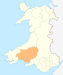
Deutsch: Lagekarte von Carmarthenshire in Wales
English: Locator map of Carmarthenshire in Wales |
| Date | |
| Source | Travail personnel |
| Auteur | NordNordWest |
| Autorisation (Réutilisation de ce fichier) |
Moi, en tant que détenteur des droits d’auteur sur cette œuvre, je la publie sous la licence suivante : Ce fichier est disponible selon les termes de la licence Creative Commons Attribution – Partage dans les Mêmes Conditions 3.0 (non transposée).
|

|
Cette carte a été créée ou améliorée dans le Kartenwerkstatt (Atelier cartographique allemand). Vous pouvez également y proposer des cartes à améliorer.
|
Historique du fichier
Cliquer sur une date et heure pour voir le fichier tel qu'il était à ce moment-là.
| Date et heure | Vignette | Dimensions | Utilisateur | Commentaire | |
|---|---|---|---|---|---|
| actuel | 4 mai 2010 à 20:49 | | 1 047 × 1 251 (151 kio) | NordNordWest | {{int:filedesc}} {{Information |Description= {{de|Lagekarte von Carmarthenshire in Wales}} {{en|Locator map of Carmarthenshire in Wales}} |Source={{Own}} |Date=2010-05-04 |Author={{U|NordNordWest}} |Permission={{self|cc-by-sa-3.0}} |other_versions= }} {{ |
Utilisation du fichier
Aucune page n’utilise ce fichier.
Usage global du fichier
Les autres wikis suivants utilisent ce fichier :
- Utilisation sur cs.wikipedia.org
- Utilisation sur de.wikipedia.org
- Utilisation sur en.wikipedia.org
- WWT Llanelli Wetlands Centre
- Carmarthenshire
- Sandy, Carmarthenshire
- Llanelli
- Carmarthen
- Llandeilo
- Newcastle Emlyn
- Whitland
- Burry Port
- Kidwelly
- Llandovery
- Laugharne
- St Clears
- Pendine
- Garreg Lwyd (Black Mountain)
- Llandybie
- Llanwrda
- Afon Cothi
- Cwmann
- Bancyfelin
- Talley
- Aber-arad
- Aber-giar
- Abergorlech
- Abernant, Carmarthenshire
- Cross Hands
- Pantyffynnon
- List of places in Carmarthenshire
- Brandy Hill, Wales
- Caio, Carmarthenshire
- Template:Carmarthenshire-geo-stub
- Bryn, Llanelli
- Pemberton, Carmarthenshire
- Dafen, Carmarthenshire
- Pendine Museum of Speed
- Usk Reservoir
- River Cywyn
- Five Roads
- Maesybont
- Glanymor
- Trefawr Track
- Bethlehem, Carmarthenshire
- Stradey
- Cross Inn
- Bronwydd
- Llanfihangel Rhos-y-Corn
- St Ishmael, Carmarthenshire
- Elvet Hundred
Voir davantage sur l’utilisation globale de ce fichier.