Fichier:View from Shafer Trail Road in Canyonlands.jpeg
Fichier d’origine (1 600 × 954 pixels, taille du fichier : 391 kio, type MIME : image/jpeg)
Ce fichier et sa description proviennent de Wikimedia Commons.
Description
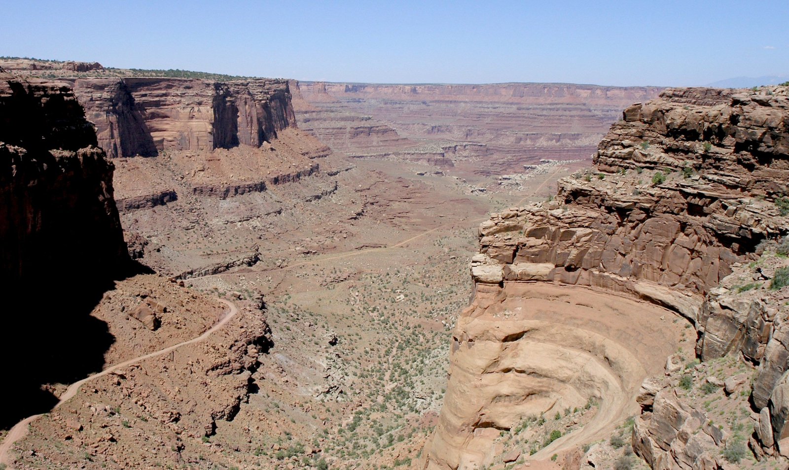
(Note, the photo is High Resolution, expandible). The view is east-northeastwards, toward (unseen) Colorado River region, south side of en:Dead Horse Point State Park, Shafer Trail (road), in Shafer Canyon region-(northeast Canyonlands National Park). The photo is taken from upper cliff, "bedded-cliff" of en:Kayenta Formation, above and in contact with the vertical-cliff of en:Wingate Sandstone.
The upper canyon is in close-up, with Shafer Trail descending to right, and skirting 3-Points, on the white en:White Rim Sandstone shelf-(overlooking the Lower Canyon, in the photo distance). There are many geologic units (in view) below the white shelf, in the distant canyon view. (see sequence, Canyonlands strat: File:Canyonlands strat.jpg). Some of the sequence visible below the White Rim Sandstone:
- Organ Rock Formation (bedded)
- Cedar Mesa Sandstone
- Elephant Canyon Formation & Halgaito Formation (slopes)
- Honaker Trail, Paradox, & Pinkerton Trail Formations
Above the White Rim Sandstone platform (shelf), and below the vertical-cliffs of the en:Wingate Sandstone-(this is in close view-(also distant view), Shafer Trail descending through it), are 8-units: from Wingate: 3-subunits (en:Chinle Formation-(only 3 units in Canyonlands)-(many states, AZ, NM, UT, CO, etc?), 4-subunits of en:Moenkopi Formation-many states-(north border AZ), and Black Box Dolomite (visible?).
The 8-subunits are:
- 3-(Chinle)-Church Rock Member
- 2-(Chinle)-Moss Back Conglomerate
- 1-(Chinle)-Temple Mountain Member
- 4 & 3-(Moenkopi)-Moody Canyon Member and Torrey Member
- 2-(Moenkopi)-Sinbad Limestone
- 1-(Moenkopi)-Black Dragon Member
- Black Box Dolomite
Conditions d’utilisation
- Vous êtes libre :
- de partager – de copier, distribuer et transmettre cette œuvre
- d’adapter – de modifier cette œuvre
- Sous les conditions suivantes :
- paternité – Vous devez donner les informations appropriées concernant l'auteur, fournir un lien vers la licence et indiquer si des modifications ont été faites. Vous pouvez faire cela par tout moyen raisonnable, mais en aucune façon suggérant que l’auteur vous soutient ou approuve l’utilisation que vous en faites.
- partage à l’identique – Si vous modifiez, transformez, ou vous basez sur cette œuvre, vous devez distribuer votre contribution sous la même licence ou une licence compatible avec celle de l’original.
Historique du fichier
Cliquer sur une date et heure pour voir le fichier tel qu'il était à ce moment-là.
| Date et heure | Vignette | Dimensions | Utilisateur | Commentaire | |
|---|---|---|---|---|---|
| actuel | 15 mars 2006 à 02:04 | | 1 600 × 954 (391 kio) | Mav | == Summary == Photo taken by Daniel Mayer in late June 2005. == Licensing == {{self|cc-by-sa-2.5}} category:Canyonlands National Park |
Utilisation du fichier
La page suivante utilise ce fichier :
Usage global du fichier
Les autres wikis suivants utilisent ce fichier :
- Utilisation sur ca.wikipedia.org