Fichier:Vesuve-NASA.jpg

Taille de cet aperçu : 601 × 600 pixels. Autres résolutions : 240 × 240 pixels | 481 × 480 pixels | 770 × 768 pixels | 1 026 × 1 024 pixels | 2 052 × 2 048 pixels | 4 089 × 4 081 pixels.
Fichier d’origine (4 089 × 4 081 pixels, taille du fichier : 4,63 Mio, type MIME : image/jpeg)
Ce fichier et sa description proviennent de Wikimedia Commons.
Description
| Description |
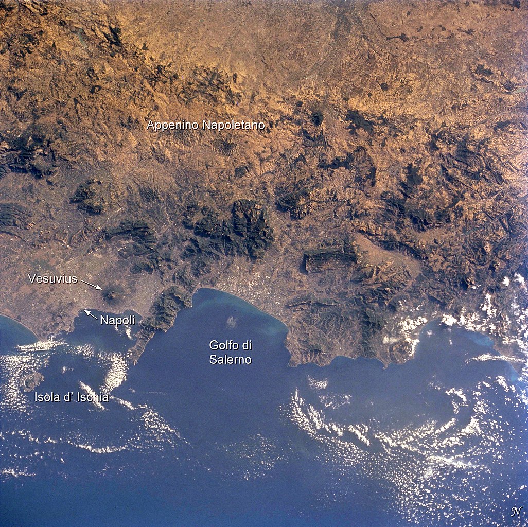
English: Photo of the bay of Naples and the Vesuvius vulcano, taken by Space Shuttle astronauts
Français : Photo satellite de la baie de Naples avec le Vésuve |
| Date | |
| Source | Earth Sciences and Image Analysis, NASA-Johnson Space Center. 16 Apr. 2004. "Earth from Space - Image Information." http://earth.jsc.nasa.gov/sseop/EFS/photoinfo.pl?PHOTO=STS104-710-60 |
| Auteur |
NASA |
Cette image ou vidéo a été cataloguée par l’un des centres de la National Aeronautics and Space Administration (NASA) des États-Unis sous Photo ID : STS104-710-60.Ce bandeau n’indique rien sur le statut de l’œuvre au regard du droit d'auteur. Un bandeau de droit d’auteur est requis. Voir Commons:À propos des licences pour plus d’informations. Autres langues :
|
Conditions d’utilisation
"The Gateway to Astronaut Photography of Earth". Image provenant du Laboratoire d'Analyse et d'Imagerie des Sciences, Centre Spatial Johnson de la NASA.
Source de la photo : STS104-710-60.
|
Journal des téléversements d’origine
(All user names refer to fr.wikipedia)
- 2004-08-05 20:18 Nataraja 540×540×8 (100321 bytes) photo satellite de la baie avec le Vésuve
Historique du fichier
Cliquer sur une date et heure pour voir le fichier tel qu'il était à ce moment-là.
| Date et heure | Vignette | Dimensions | Utilisateur | Commentaire | |
|---|---|---|---|---|---|
| actuel | 2 décembre 2014 à 19:14 | | 4 089 × 4 081 (4,63 Mio) | Ras67 | with captions |
| 2 décembre 2014 à 19:09 |  | 4 089 × 4 081 (4,55 Mio) | Ras67 | high resolution without captions | |
| 6 février 2007 à 10:29 |  | 540 × 540 (98 kio) | Bilou~commonswiki | {{Information |Description=photo satellite de la baie de Naples avec le Vésuve |Source=Earth Sciences and Image Analysis, NASA-Johnson Space Center. 16 Apr. 2004. "Earth from Space - Image Information." http://earth.jsc.nasa.gov/sseop/EFS/photoinfo.pl?PH |
Utilisation du fichier
La page suivante utilise ce fichier :
Usage global du fichier
Les autres wikis suivants utilisent ce fichier :
- Utilisation sur ca.wikipedia.org
- Utilisation sur de.wikipedia.org
- Utilisation sur eo.wikipedia.org
- Utilisation sur nl.wikipedia.org
- Utilisation sur rm.wikipedia.org