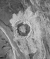
Fichier:Venus Dickinson Crater.jpg

Taille de cet aperçu : 508 × 600 pixels. Autres résolutions : 203 × 240 pixels | 406 × 480 pixels | 847 × 1 000 pixels.
Fichier d’origine (847 × 1 000 pixels, taille du fichier : 388 kio, type MIME : image/jpeg)
Historique du fichier
Cliquer sur une date et heure pour voir le fichier tel qu'il était à ce moment-là.
| Date et heure | Vignette | Dimensions | Utilisateur | Commentaire | |
|---|---|---|---|---|---|
| actuel | 6 août 2005 à 12:51 |  | 847 × 1 000 (388 kio) | Vzb83~commonswiki | '''Original Caption Released with Image:''' This Magellan image is centered at 74.6 degrees north latitude and 177.3 east longitude, in the northeastern Atalanta Region of Venus. The image is approximately 185 kilometers (115 miles) wide at the base and |
Utilisation du fichier
Les 2 pages suivantes utilisent ce fichier :
Usage global du fichier
Les autres wikis suivants utilisent ce fichier :
- Utilisation sur ast.wikipedia.org
- Utilisation sur ca.wikipedia.org
- Utilisation sur ce.wikipedia.org
- Utilisation sur en.wikipedia.org
- Utilisation sur es.wikipedia.org
- Utilisation sur fi.wikipedia.org
- Utilisation sur gl.wikipedia.org
- Utilisation sur hy.wikipedia.org
- Utilisation sur it.wikipedia.org
- Utilisation sur nl.wikipedia.org
- Utilisation sur ru.wikipedia.org
- Utilisation sur sr.wikipedia.org
- Utilisation sur tt.wikipedia.org
- Utilisation sur www.wikidata.org
- Utilisation sur zh.wikipedia.org

