Fichier:ValcourIslandMap1776Detail.jpg

Taille de cet aperçu : 541 × 599 pixels. Autres résolutions : 217 × 240 pixels | 434 × 480 pixels | 803 × 889 pixels.
Fichier d’origine (803 × 889 pixels, taille du fichier : 337 kio, type MIME : image/jpeg)
Ce fichier et sa description proviennent de Wikimedia Commons.
Description
| Description |
English:

|
||||||||||||||||||||||
| Date | |||||||||||||||||||||||
| Source |
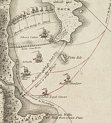
From the Boston Public Library Digital Maps Collection (http://maps.bpl.org/). |
||||||||||||||||||||||
| Auteur |
|
||||||||||||||||||||||
Conditions d’utilisation
|
Cette œuvre est également dans le domaine public dans tous les pays pour lesquels le droit d’auteur a une durée de vie de 100 ans ou moins après la mort de l’auteur. | |
| Ce fichier a été identifié comme étant exempt de restrictions connues liées au droit d’auteur, y compris tous les droits connexes et voisins. | |
Historique du fichier
Cliquer sur une date et heure pour voir le fichier tel qu'il était à ce moment-là.
| Date et heure | Vignette | Dimensions | Utilisateur | Commentaire | |
|---|---|---|---|---|---|
| actuel | 17 février 2009 à 23:29 | | 803 × 889 (337 kio) | Magicpiano | Higher-res version. |
| 17 février 2009 à 23:23 |  | 189 × 214 (23 kio) | Magicpiano | {{Information |Description={{en|1=thumb|right|source map showing area detailed in this image This is a blowup of the area highlighted in the map shown to the right, showing the detail of the action in the [[w:Bat |
Utilisation du fichier
Les 2 pages suivantes utilisent ce fichier :
Usage global du fichier
Les autres wikis suivants utilisent ce fichier :
- Utilisation sur ca.wikipedia.org
- Utilisation sur de.wikipedia.org
- Utilisation sur en.wikipedia.org
- Utilisation sur es.wikipedia.org
- Utilisation sur fi.wikipedia.org
- Utilisation sur it.wikipedia.org
- Utilisation sur ja.wikipedia.org
- Utilisation sur no.wikipedia.org
- Utilisation sur ru.wikipedia.org
- Utilisation sur simple.wikipedia.org
- Utilisation sur www.wikidata.org