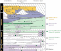
Fichier:Uinta Piceance Basin stratigraphic column.gif

Taille de cet aperçu : 729 × 600 pixels. Autres résolutions : 292 × 240 pixels | 584 × 480 pixels | 934 × 768 pixels | 1 274 × 1 048 pixels.
Fichier d’origine (1 274 × 1 048 pixels, taille du fichier : 122 kio, type MIME : image/gif, 0,1 s)
Historique du fichier
Cliquer sur une date et heure pour voir le fichier tel qu'il était à ce moment-là.
| Date et heure | Vignette | Dimensions | Utilisateur | Commentaire | |
|---|---|---|---|---|---|
| actuel | 19 novembre 2023 à 21:56 |  | 1 274 × 1 048 (122 kio) | Hike395 | better gif |
| 19 novembre 2023 à 20:16 |  | 1 250 × 1 044 (181 kio) | Hike395 | {{Information |Description=Generalized stratigraphic column of the Uinta-Piceance Province |Source={{cite web|url=https://pubs.usgs.gov/dds/dds-069/dds-069-b/REPORTS/Chapter_2.pdf|title=The Unita-Piceance Province|page=8|publisher=USGS|work=Digital Data Series DDS-69-B}} |Date=2003 |Author=USGS Uinta-Piceance Assessment Team |Permission={{PD-USGov-USGS}} |other_versions=png version with tighter crop }} |
Utilisation du fichier
La page suivante utilise ce fichier :
Usage global du fichier
Les autres wikis suivants utilisent ce fichier :
- Utilisation sur en.wikipedia.org
