Fichier:US Overflight Fee Map.png
Pas de plus haute résolution disponible.
US_Overflight_Fee_Map.png (375 × 272 pixels, taille du fichier : 28 kio, type MIME : image/png)
Ce fichier et sa description proviennent de Wikimedia Commons.
Description
| Description |
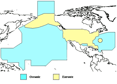
English: A map of the regions where the United States charges overflight fees. Yellow is where higher "enroute" fees are charged. Blue is where "oceanic" fees are charged. The colored regions of this map correspond to the regions where the US has delegated authority by the ICAO to control air traffic, including over international waters. |
| Date | Date inconnue |
| Source | http://www.faa.gov/about/office_org/headquarters_offices/aba/overflight_fees/ |
| Auteur | Federal Aviation Administration |
Conditions d’utilisation
This image or file is a work of a Federal Aviation Administration employee, taken or made as part of that person's official duties. As a work of the U.S. federal government, the image is in the public domain in the United States.
|
 |
Historique du fichier
Cliquer sur une date et heure pour voir le fichier tel qu'il était à ce moment-là.
| Date et heure | Vignette | Dimensions | Utilisateur | Commentaire | |
|---|---|---|---|---|---|
| actuel | 9 août 2014 à 04:52 | | 375 × 272 (28 kio) | AHeneen | User created page with UploadWizard |
Utilisation du fichier
La page suivante utilise ce fichier :
Usage global du fichier
Les autres wikis suivants utilisent ce fichier :
- Utilisation sur af.wikipedia.org
- Utilisation sur en.wikipedia.org
- Utilisation sur it.wikipedia.org
- Utilisation sur ja.wikipedia.org
- Utilisation sur zh.wikipedia.org