Fichier:UNR 2.1918 Brest-Litovsk.png
Taille de cet aperçu : 800 × 487 pixels. Autres résolutions : 320 × 195 pixels | 640 × 389 pixels | 1 024 × 623 pixels | 1 280 × 779 pixels | 1 698 × 1 033 pixels.
Fichier d’origine (1 698 × 1 033 pixels, taille du fichier : 432 kio, type MIME : image/png)
Ce fichier et sa description proviennent de Wikimedia Commons.
Description
| Description |
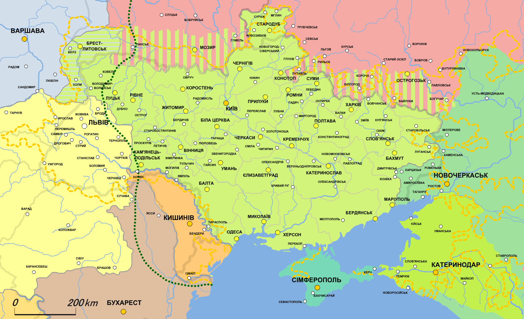
English: Map of the Ukrainian People's Republic (1918.II))
UPR according to the Treaty of Brest-Litovsk)
Disputed territories
Borders of residence of Ukrainians
Limits of the advance of German-Austrian troops in autumn 1917
Podlachia, transferred to the UPR under the terms of the Treaty of Brest-Litovsk
Soviet Russia
Don regional government of General Krasnov
Kuban regional government
Crimean Tatar government
Austro-Hungarian Empire
Polish Regency Council
Kingdom of Romania
Moldovan People's Republic
Serbia Українська: Карта Української Народної Республіки (1918.II)
УНР за Брест-Литовським договором)
Спірні території
Межі проживання українців
Межі просування німецько-австрійських військ восени 1917
Підляшшя, передане УНР за умовами Брест-Литовського договору
Радянська Росія
Донський крайовий уряд генерала Краснова
Кубанський крайовий уряд
Кримсько-татарський уряд
Австро-Угорська Імперія
Польська регентська рада
Румунське королівство
Молдавська народна республіка
Сербія |
| Date | |
| Source | Travail personnel, based on Початок визвольних змагань українського народу. Утворення УНР (березень 1917 - березень 1918 р) // Атлас історії України. 10 клас |
| Auteur | Alex Tora |
Ce fichier est disponible selon les termes de la licence Creative Commons Attribution – Partage dans les Mêmes Conditions 2.1 Japon
- Vous êtes libre :
- de partager – de copier, distribuer et transmettre cette œuvre
- d’adapter – de modifier cette œuvre
- Sous les conditions suivantes :
- paternité – Vous devez donner les informations appropriées concernant l'auteur, fournir un lien vers la licence et indiquer si des modifications ont été faites. Vous pouvez faire cela par tout moyen raisonnable, mais en aucune façon suggérant que l’auteur vous soutient ou approuve l’utilisation que vous en faites.
- partage à l’identique – Si vous modifiez, transformez, ou vous basez sur cette œuvre, vous devez distribuer votre contribution sous la même licence ou une licence compatible avec celle de l’original.


|
Cette image (de type historical map) devrait être recréée dans un format vectoriel, en tant que fichier SVG. Cela offrirait plusieurs avantages : voir Commons:Media for cleanup pour plus d'informations. Si une version SVG de cette image est déjà disponible, merci de bien vouloir l'envoyer. Après cela, remplacez ce modèle par {{vector version available|nouveau nom d'image.svg}}.
|
Historique du fichier
Cliquer sur une date et heure pour voir le fichier tel qu'il était à ce moment-là.
| Date et heure | Vignette | Dimensions | Utilisateur | Commentaire | |
|---|---|---|---|---|---|
| actuel | 21 janvier 2022 à 20:14 | | 1 698 × 1 033 (432 kio) | Super Dromaeosaurus | Romania-Ukraine border at Dniester |
| 21 janvier 2012 à 15:30 |  | 1 698 × 1 033 (535 kio) | Alex Tora | {{Information |Description={{uk|Карта Української Народної Республіки (1918.II)}} {{legend|#A0FF53|УНР за Брест-Литовським договором (17 серпня 1917)}} {{Legend|#A0FF53|Спірні те |
Utilisation du fichier
Les 2 pages suivantes utilisent ce fichier :
Usage global du fichier
Les autres wikis suivants utilisent ce fichier :
- Utilisation sur ca.wikipedia.org
- Utilisation sur en.wikipedia.org
- Utilisation sur es.wikipedia.org
- Utilisation sur it.wikipedia.org
- Utilisation sur lv.wikipedia.org
- Utilisation sur mk.wikipedia.org
- Utilisation sur mt.wikipedia.org
- Utilisation sur ru.wikipedia.org
- Utilisation sur th.wikipedia.org
- Utilisation sur uk.wikipedia.org
- Utilisation sur vi.wikipedia.org
- Utilisation sur zh.wikipedia.org