Fichier:Tide legal use.gif
Pas de plus haute résolution disponible.
Tide_legal_use.gif (720 × 477 pixels, taille du fichier : 31 kio, type MIME : image/gif)
Ce fichier et sa description proviennent de Wikimedia Commons.
Description
| Description |
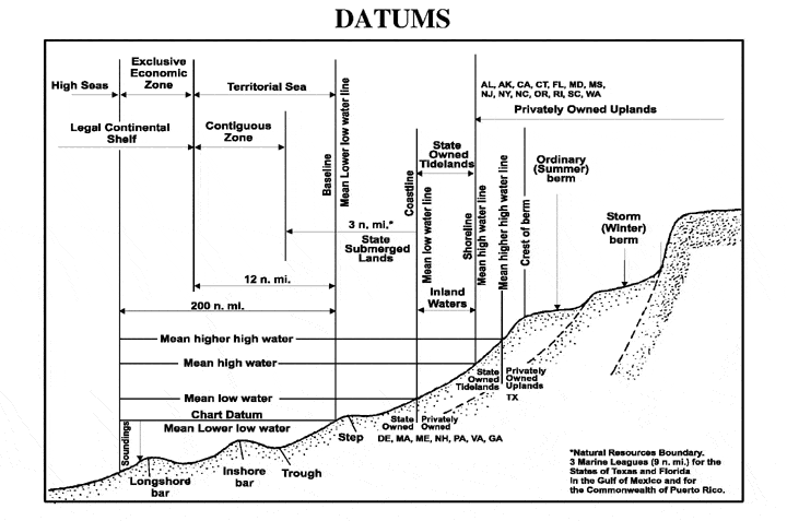
English: The principal tidal data related to a beach profile. The intersection of the tidal datum with land determines the landward edge of a marine boundary. |
| Source |
From NOS Tidal Datums Pub (on Naval Postgraduate School). http://www.oc.nps.navy.mil/nom/day1/partc.html figure:a http://www.oc.nps.navy.mil/nom/day1/tidal_datums_fig17.gif |
| Auteur |
Conditions d’utilisation
Cette image est l'œuvre d'un marin ou d'un employé de l'U.S. Navy, créée dans l'exercice de ses fonctions. En tant qu'œuvre du gouvernement fédéral des États-Unis, cette image est dans le domaine public.
|
 | |
| Ce fichier a été identifié comme étant exempt de restrictions connues liées au droit d’auteur, y compris tous les droits connexes et voisins. | ||
Journal des téléversements d’origine
Transféré de en.wikipedia à Commons utilisant For the Common Good.
La page de description originale était ici. Tous les noms d'utilisateur qui suivent se rapportent à en.wikipedia.
| Date et heure | Dimensions | Utilisateur | Commentaire |
|---|---|---|---|
| 00:41, 12 April 2007 | 720 × 477 (31,829 bytes) | w:en:Rmo13 (d | contributions) | page: The principal tidal datums related to a beach profile. The intersection of the tidal datum with land determines the landward edge of a marine boundary. From NOS Tidal Datums Pub (on Naval Postgraduate School). http://www.oc.nps.navy.mil/nom/day1/par |
Historique du fichier
Cliquer sur une date et heure pour voir le fichier tel qu'il était à ce moment-là.
| Date et heure | Vignette | Dimensions | Utilisateur | Commentaire | |
|---|---|---|---|---|---|
| actuel | 20 novembre 2016 à 18:16 | | 720 × 477 (31 kio) | Mcapdevila | Transferred from en.wikipedia: see original upload log above |
Utilisation du fichier
La page suivante utilise ce fichier :
Usage global du fichier
Les autres wikis suivants utilisent ce fichier :
- Utilisation sur ca.wikipedia.org
- Utilisation sur cs.wikipedia.org
- Utilisation sur en.wikipedia.org
- Utilisation sur fa.wikipedia.org
- Utilisation sur vi.wikipedia.org
- Utilisation sur zh.wikipedia.org