Fichier:Theoreticaltownshipmap.gif
Taille de cet aperçu : 554 × 600 pixels. Autres résolutions : 222 × 240 pixels | 444 × 480 pixels | 694 × 751 pixels.
Fichier d’origine (694 × 751 pixels, taille du fichier : 70 kio, type MIME : image/gif)
Ce fichier et sa description proviennent de Wikimedia Commons.
Description
| Description |
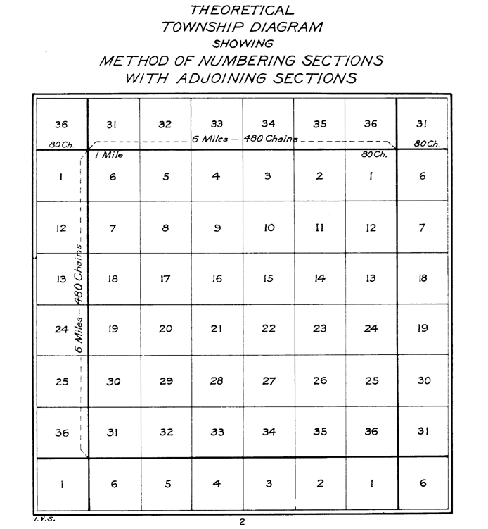
English: The image depicts a standard survey township with its 36 sections and the correponding sections from the surrounding survey townships. |
|||
| Date | ||||
| Source | The image was tansferred from the en.wiki. If necessary, it could be found here. | |||
| Auteur |
The image was done by the US Interior Bureau of Land Management
|
Conditions d’utilisation
Ce média est dans le domaine public des États-Unis d’Amérique car son auteur est l’administration américaine comme précisé dans le code fédéral au Titre 17, Chapitre 1, Section 105. Pour en savoir plus : droit d’auteur.
Attention : Ceci ne concerne que le travail du Gouvernement Fédéral et pas celui des États, ou d’une autre subdivision géographique ou politique du pays.
|
 | |
| Ce fichier a été identifié comme étant exempt de restrictions connues liées au droit d’auteur, y compris tous les droits connexes et voisins. | ||
| This image is a work of a Bureau of Land Management* employee, taken or made as part of that person's official duties. As a work of the U.S. federal government, the image is in the public domain in the United States. *or predecessor organization |
Historique du fichier
Cliquer sur une date et heure pour voir le fichier tel qu'il était à ce moment-là.
| Date et heure | Vignette | Dimensions | Utilisateur | Commentaire | |
|---|---|---|---|---|---|
| actuel | 22 décembre 2011 à 23:25 | | 694 × 751 (70 kio) | Wars |
Utilisation du fichier
La page suivante utilise ce fichier :
Usage global du fichier
Les autres wikis suivants utilisent ce fichier :
- Utilisation sur ca.wikipedia.org
- Utilisation sur en.wikipedia.org
- Utilisation sur hu.wikipedia.org
- Utilisation sur it.wikipedia.org
- Utilisation sur ro.wikipedia.org