Fichier:The Tombstone of the Battleford Eight.jpg
Taille de cet aperçu : 800 × 600 pixels. Autres résolutions : 320 × 240 pixels | 640 × 480 pixels | 1 024 × 768 pixels | 1 280 × 960 pixels | 2 560 × 1 920 pixels | 4 896 × 3 672 pixels.
Fichier d’origine (4 896 × 3 672 pixels, taille du fichier : 6,73 Mio, type MIME : image/jpeg)
Ce fichier et sa description proviennent de Wikimedia Commons.
Description
| Description |
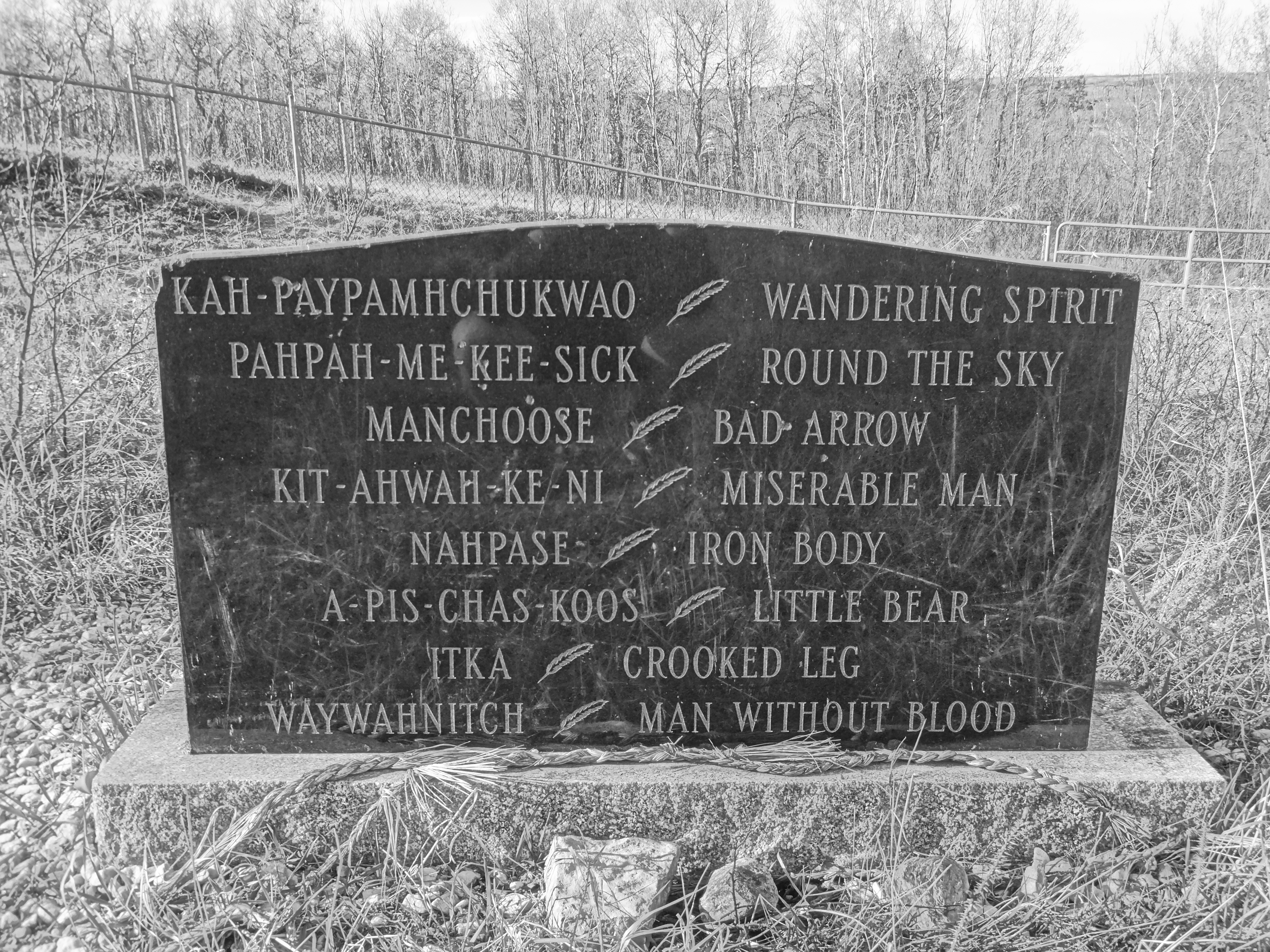
English: The gravesite of the Battleford Eight in Battleford, Saskatchewan, Canada. This is the gravesite of the largest mass hanging in the history of Canada which occurred on November 27th, 1885 in the wake of the Riel Resistance.
Documents at the time show that the Judge who condemned the Battleford eight to hang at Fort Battleford was accused of severe bias, the Saskatchewan Herald reported on December 14th, 1885 that a telegram was making the rounds of the press stating that Judge Charles Rouleau "is reported to have threatened that every Indian and Half-breed and rebel brought before him after the insurrection was suppressed, would be sent to the gallows if possible. In view of all the circumstances, and particularly as Judge Rouleau was a heavy loser pecuniarily by the Indian outbreak at Battleford, it is contended that he should not have been allowed to preside at the trial of the prisoners. A memorial has been received by the Department of Justice asking that the matter be investigated." |
| Date | |
| Source | Travail personnel |
| Auteur | Saskg |
| Lieu de la prise de vue | | Voir cet endroit et d’autres images sur : OpenStreetMap |
|---|
The site of the graves is public.
Conditions d’utilisation
Moi, en tant que détenteur des droits d’auteur sur cette œuvre, je la publie sous la licence suivante :
Ce fichier est sous la licence Creative Commons Attribution – Partage dans les Mêmes Conditions 4.0 International.
- Vous êtes libre :
- de partager – de copier, distribuer et transmettre cette œuvre
- d’adapter – de modifier cette œuvre
- Sous les conditions suivantes :
- paternité – Vous devez donner les informations appropriées concernant l'auteur, fournir un lien vers la licence et indiquer si des modifications ont été faites. Vous pouvez faire cela par tout moyen raisonnable, mais en aucune façon suggérant que l’auteur vous soutient ou approuve l’utilisation que vous en faites.
- partage à l’identique – Si vous modifiez, transformez, ou vous basez sur cette œuvre, vous devez distribuer votre contribution sous la même licence ou une licence compatible avec celle de l’original.
Historique du fichier
Cliquer sur une date et heure pour voir le fichier tel qu'il était à ce moment-là.
| Date et heure | Vignette | Dimensions | Utilisateur | Commentaire | |
|---|---|---|---|---|---|
| actuel | 7 mai 2017 à 04:34 | | 4 896 × 3 672 (6,73 Mio) | Embedded Data Bot | This file contains embedded data: After 6.7MiB (7059968 bytes, via Ending): Identified type: image/jpeg (JPEG image data, Exif standard: [TIFF image data, little-endian, direntries=4, xresolution=62, yresolution=70, resolutionunit=2], ba... |
| 7 mai 2017 à 04:34 |  | 4 896 × 3 672 (7,53 Mio) | Saskg | User created page with UploadWizard |
Utilisation du fichier
La page suivante utilise ce fichier :
Usage global du fichier
Les autres wikis suivants utilisent ce fichier :
- Utilisation sur en.wikipedia.org
- Utilisation sur www.wikidata.org