Fichier:The Citadel of Alanya.jpg
Fichier d’origine (1 000 × 750 pixels, taille du fichier : 360 kio, type MIME : image/jpeg)
Ce fichier et sa description proviennent de Wikimedia Commons.
Description
| Description |
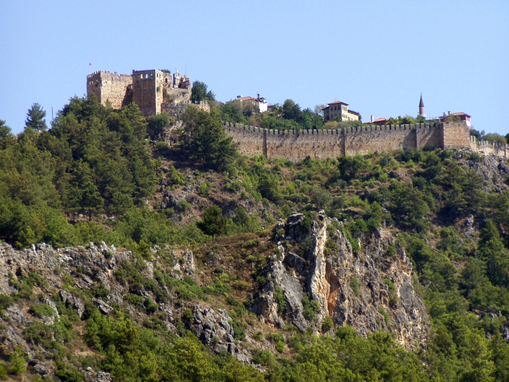
The citadel viewed from the city. The Citadel of Alanya, the walls of which are nearly 6.5 kilometres long, is on a peninsula whose height is up to 250 metres from the sea level. Although the settlement on Alanya peninsula, also known as Kandeleri, dates back to the Hellenistic Era, its cultural characteristics that can be seen today are thanks to Selcuks of the 13th century. The citadel was constructed on the demand of the Sultan of Selcuks, Alaaddin Keykubat, who conquered and had the city rebuilt in 1221. The citadel has 83 towers and 140 bastions. Nearly 400 cisterns were built to supply the city surrounded by walks in the medieval times with water. Some of the cisterns are still used today. The Seljuk Empire used Alanya as a second capital city in addition to Konya and used the city as a winter residence and made improvements there. Mongol attacks in 1243 and the Invasion of Anatolia by Egyptian Memluks weakened the Seljuk Empire which was divided in 1300, and the region came under the reign of the Karamano?ullar? dynasty. In 1427 Alanya was sold to the Memluk Sultan for five thousand gold pieces, and then in 1471 the city was included within the borders of the Ottoman Empire by Mehmet II The Conqueror. ( www.alanya.com.tr/en/47-Historical-Places.html ) |
| Date | |
| Source |
Türkiye - The Citadel of Alanya
|
| Auteur | Robin & Bazylek from Kraków, Poland |
| Lieu de la prise de vue | | Voir cet endroit et d’autres images sur : OpenStreetMap |
|---|
Conditions d’utilisation
- Vous êtes libre :
- de partager – de copier, distribuer et transmettre cette œuvre
- d’adapter – de modifier cette œuvre
- Sous les conditions suivantes :
- paternité – Vous devez donner les informations appropriées concernant l'auteur, fournir un lien vers la licence et indiquer si des modifications ont été faites. Vous pouvez faire cela par tout moyen raisonnable, mais en aucune façon suggérant que l’auteur vous soutient ou approuve l’utilisation que vous en faites.
| Cette image, qui provient de Flickr, a été vérifiée le April 21, 2009 par l'administrateur ou l'utilisateur de confiance (trusted user) File Upload Bot (Magnus Manske), qui a confirmé qu'à cette date, elle était publiée sur Flickr sous cette licence. |
Historique du fichier
Cliquer sur une date et heure pour voir le fichier tel qu'il était à ce moment-là.
| Date et heure | Vignette | Dimensions | Utilisateur | Commentaire | |
|---|---|---|---|---|---|
| actuel | 21 avril 2009 à 17:59 | | 1 000 × 750 (360 kio) | File Upload Bot (Magnus Manske) | {{Information |Description= The citadel viewed from the city. The Citadel of Alanya, the walls of which are nearly 6.5 kilometres long, is on a peninsula whose height is up to 250 metres from the sea level. Although the settlement on Alanya peninsula, a |
Utilisation du fichier
Les 2 pages suivantes utilisent ce fichier :
Usage global du fichier
Les autres wikis suivants utilisent ce fichier :
- Utilisation sur ar.wikipedia.org
- Utilisation sur ba.wikipedia.org
- Utilisation sur de.wikipedia.org
- Utilisation sur es.wikipedia.org
- Utilisation sur hu.wikipedia.org
- Utilisation sur hy.wikipedia.org
- Utilisation sur pt.wikipedia.org
- Utilisation sur ru.wikipedia.org
- Utilisation sur tg.wikipedia.org