Fichier:Sandy 2012-10-29 1515Z.png

Taille de cet aperçu : 800 × 450 pixels. Autres résolutions : 320 × 180 pixels | 640 × 360 pixels | 1 024 × 576 pixels | 1 280 × 720 pixels | 1 920 × 1 080 pixels.
Fichier d’origine (1 920 × 1 080 pixels, taille du fichier : 2,07 Mio, type MIME : image/png)
Ce fichier et sa description proviennent de Wikimedia Commons.
Description
| Description |
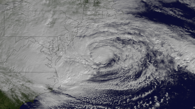
English: Hurricane Sandy, with winds of 90 mph and heavy rains, is creating dangerous flooding conditions all along the Northeast U.S. from NC to New England. This NOAA GOES-13 satellite image taken on October 29, 2012 shows the storm as it is centered off of Maryland and Virginia. The storm is heading in a northwestern direction towards the Delaware and southern New Jersey coast. |
| Date | |
| Source | http://www.nnvl.noaa.gov/MediaDetail2.php?MediaID=1223&MediaTypeID=1 |
| Auteur | The National Oceanic and Atmospheric Administration |
Conditions d’utilisation
Cette image est dans le domaine public car son contenu provient de la
National Oceanic and Atmospheric Administration , réalisé par un employé dans le cadre de ses activités professionnelles.
|
Historique du fichier
Cliquer sur une date et heure pour voir le fichier tel qu'il était à ce moment-là.
| Date et heure | Vignette | Dimensions | Utilisateur | Commentaire | |
|---|---|---|---|---|---|
| actuel | 9 avril 2018 à 10:27 | | 1 920 × 1 080 (2,07 Mio) | A1Cafel | remove logo |
| 29 octobre 2012 à 22:22 |  | 1 920 × 1 080 (1,93 Mio) | Supportstorm | {{Information |Description ={{en|1=Hurricane Sandy, with winds of 90 mph and heavy rains, is creating dangerous flooding conditions all along the Northeast U.S. from NC to New England. This NOAA GOES-13 satellite image taken on October 29, 2012 show... |
Utilisation du fichier
La page suivante utilise ce fichier :
Usage global du fichier
Les autres wikis suivants utilisent ce fichier :
- Utilisation sur el.wikipedia.org
- Utilisation sur sr.wikinews.org