Fichier:Round Tower - Clondalkin - geograph.org.uk - 108911.jpg
Taille de cet aperçu : 449 × 600 pixels. Autres résolutions : 179 × 240 pixels | 479 × 640 pixels.
Fichier d’origine (479 × 640 pixels, taille du fichier : 66 kio, type MIME : image/jpeg)
Ce fichier et sa description proviennent de Wikimedia Commons.
Description
| Description |
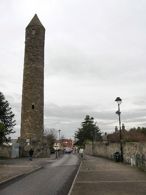
English: Round Tower - Clondalkin. Well preserved 8th century round tower that acts as a focal point for the area. Acknowledged as one of the oldest and best preserved in the country, it is 84 feet high and has its original conical cap. The foundation of the first monastery is attributed to St. Cronan, otherwise called Mo-Chua, who lived possibly in the 6th century. The monastery is first mentioned in 776. It was plundered by the Vikings in 832. [info from http://www.irish-architecture.com] |
| Date | |
| Source | From geograph.org.uk |
| Auteur | Paul Johnston-Knight |
| Attribution (imposé par la licence) | Paul Johnston-Knight / Round Tower - Clondalkin / |
| Position de l'objet | | Voir cet endroit et d’autres images sur : OpenStreetMap |
|---|
_heading:0.00&language=fr)
Conditions d’utilisation

|
Cette image provient de la collection du projet Geograph British Isles. Pour obtenir les coordonnées du photographe, veuillez consulter cette page de description de l'image sur le site du projet. Les droits d'auteurs sur cette image sont détenus par Paul Johnston-Knight ; l'image est placée sous une licence Creative Commons avec mention de paternité et partage à l'identique (CC-By-SA) en version 2.0.
|
Ce fichier est disponible selon les termes de la licence Creative Commons Attribution – Partage dans les Mêmes Conditions 2.0 Générique
Attribution: Paul Johnston-Knight
- Vous êtes libre :
- de partager – de copier, distribuer et transmettre cette œuvre
- d’adapter – de modifier cette œuvre
- Sous les conditions suivantes :
- paternité – Vous devez donner les informations appropriées concernant l'auteur, fournir un lien vers la licence et indiquer si des modifications ont été faites. Vous pouvez faire cela par tout moyen raisonnable, mais en aucune façon suggérant que l’auteur vous soutient ou approuve l’utilisation que vous en faites.
- partage à l’identique – Si vous modifiez, transformez, ou vous basez sur cette œuvre, vous devez distribuer votre contribution sous la même licence ou une licence compatible avec celle de l’original.
Historique du fichier
Cliquer sur une date et heure pour voir le fichier tel qu'il était à ce moment-là.
| Date et heure | Vignette | Dimensions | Utilisateur | Commentaire | |
|---|---|---|---|---|---|
| actuel | 8 avril 2011 à 11:31 | | 479 × 640 (66 kio) | Hydro | Tonwertkorrektur |
| 31 janvier 2010 à 03:33 |  | 479 × 640 (60 kio) | GeographBot | == {{int:filedesc}} == {{Information |description={{en|1=Round Tower - Clondalkin. Well preserved 8th century round tower that acts as a focal point for the area. Acknowledged as one of the oldest and best preserved in the country, it is 84 feet high and |
Utilisation du fichier
La page suivante utilise ce fichier :
Usage global du fichier
Les autres wikis suivants utilisent ce fichier :
- Utilisation sur be-tarask.wikipedia.org
- Utilisation sur bg.wikipedia.org
- Utilisation sur ca.wikipedia.org
- Utilisation sur ceb.wikipedia.org
- Utilisation sur de.wikipedia.org
- Utilisation sur en.wikipedia.org
- Utilisation sur es.wikipedia.org
- Utilisation sur eu.wikipedia.org
- Utilisation sur fa.wikipedia.org
- Utilisation sur ga.wikipedia.org
- Utilisation sur gd.wikipedia.org
- Utilisation sur he.wikipedia.org
- Utilisation sur it.wikipedia.org
- Utilisation sur ka.wikipedia.org
- Utilisation sur nl.wikipedia.org
- Utilisation sur pl.wikipedia.org
- Utilisation sur ru.wikipedia.org
- Utilisation sur sl.wikipedia.org
- Utilisation sur sv.wikipedia.org
- Utilisation sur ur.wikipedia.org
- Utilisation sur www.wikidata.org