Fichier:Regional flights from Cape Town International Airport.svg

Taille de cet aperçu PNG pour ce fichier SVG : 600 × 400 pixels. Autres résolutions : 320 × 213 pixels | 640 × 427 pixels | 1 024 × 683 pixels | 1 280 × 853 pixels | 2 560 × 1 707 pixels.
Fichier d’origine (Fichier SVG, nominalement de 600 × 400 pixels, taille : 336 kio)
Ce fichier et sa description proviennent de Wikimedia Commons.
Description
| Description |
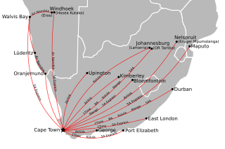
English: Map showing flights from Cape Town International Airport to destinations within Southern Africa, as of 1 July 2009. See File:International flights from Cape Town International Airport.svg for flights outside of Southern Africa.
Cette image vectorielle non W3C-spécifiée a été créée avec Inkscape . |
| Date | |
| Source | Own work by uploader; country basemap from File:BlankMap-Africa.svg. |
| Auteur | Htonl |
| Autres versions | File:Regional flights from Cape Town International Airport, with IATA codes.svg, version with IATA codes instead of English names. |
Conditions d’utilisation
Moi, en tant que détenteur des droits d’auteur sur cette œuvre, je la publie sous les licences suivantes :
Ce fichier est disponible selon les termes de la licence Creative Commons Attribution – Partage dans les Mêmes Conditions 3.0 (non transposée).
- Vous êtes libre :
- de partager – de copier, distribuer et transmettre cette œuvre
- d’adapter – de modifier cette œuvre
- Sous les conditions suivantes :
- paternité – Vous devez donner les informations appropriées concernant l'auteur, fournir un lien vers la licence et indiquer si des modifications ont été faites. Vous pouvez faire cela par tout moyen raisonnable, mais en aucune façon suggérant que l’auteur vous soutient ou approuve l’utilisation que vous en faites.
- partage à l’identique – Si vous modifiez, transformez, ou vous basez sur cette œuvre, vous devez distribuer votre contribution sous la même licence ou une licence compatible avec celle de l’original.

|
Vous avez la permission de copier, distribuer et modifier ce document selon les termes de la GNU Free Documentation License version 1.2 ou toute version ultérieure publiée par la Free Software Foundation, sans sections inaltérables, sans texte de première page de couverture et sans texte de dernière page de couverture. Un exemplaire de la licence est inclus dans la section intitulée GNU Free Documentation License. |
Vous pouvez choisir l’une de ces licences.
Historique du fichier
Cliquer sur une date et heure pour voir le fichier tel qu'il était à ce moment-là.
| Date et heure | Vignette | Dimensions | Utilisateur | Commentaire | |
|---|---|---|---|---|---|
| actuel | 5 juillet 2009 à 04:04 | | 600 × 400 (336 kio) | Htonl | minor adjustments |
| 5 juillet 2009 à 01:34 |  | 600 × 400 (336 kio) | Htonl | make background opaque | |
| 5 juillet 2009 à 01:28 |  | 600 × 400 (336 kio) | Htonl | change airline labelling scheme | |
| 5 juillet 2009 à 00:13 |  | 600 × 400 (338 kio) | Htonl | small adjustment | |
| 4 juillet 2009 à 23:48 |  | 600 × 400 (345 kio) | Htonl | crop + size | |
| 4 juillet 2009 à 23:43 |  | 622 × 461 (346 kio) | Htonl | {{Information |Description={{en|1=Map showing flights from w:Cape Town International Airport to destinations within Southern Africa, as of 1 July 2009.}} |Source=Own work by uploader; country basemap from File:BlankMap-Africa.svg. |Author=[[User: |
Utilisation du fichier
La page suivante utilise ce fichier :
Usage global du fichier
Les autres wikis suivants utilisent ce fichier :
- Utilisation sur af.wikipedia.org
- Utilisation sur cs.wikipedia.org
- Utilisation sur es.wikipedia.org
- Utilisation sur id.wikipedia.org
- Utilisation sur it.wikipedia.org
- Utilisation sur ru.wikipedia.org