Fichier:Recknitz.png

Taille de cet aperçu : 378 × 599 pixels. Autres résolutions : 151 × 240 pixels | 303 × 480 pixels | 485 × 768 pixels | 646 × 1 024 pixels | 1 413 × 2 238 pixels.
Fichier d’origine (1 413 × 2 238 pixels, taille du fichier : 2,95 Mio, type MIME : image/png)
Ce fichier et sa description proviennent de Wikimedia Commons.
Description
| Description |
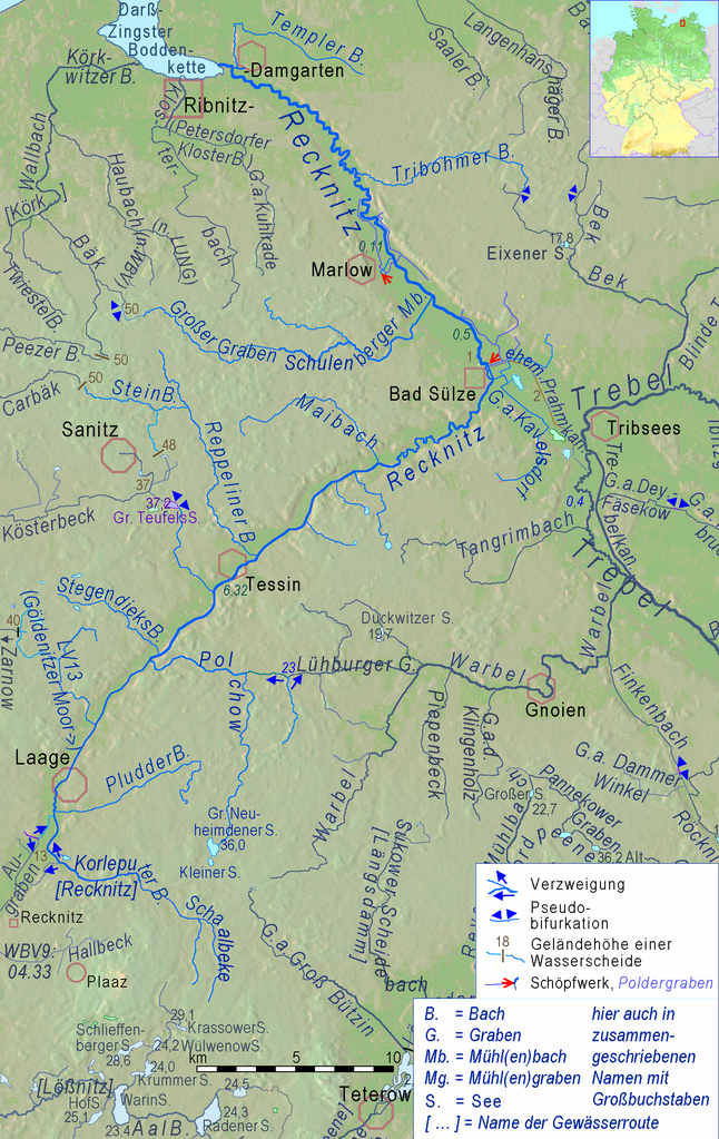
English: Recknitz River and its connections in a cut of Peene river system.
Deutsch: Recknitz und ihre Verbindungen mit Nachbargewässern im Ausschnitt einer physischen Karte des Flusssystems der Peene. |
| Source |
Adapted cut of File:Peene Flusssystem Relief.png , created by myself in 2019 using Openstreetmap & http://www.maps-for-free.html |
| Auteur | Ulamm (talk) 18:57, 22 November 2013 (UTC) |
Conditions d’utilisation
Ce fichier est disponible selon les termes de la licence Creative Commons Attribution – Partage dans les Mêmes Conditions 3.0 (non transposée).
- Vous êtes libre :
- de partager – de copier, distribuer et transmettre cette œuvre
- d’adapter – de modifier cette œuvre
- Sous les conditions suivantes :
- paternité – Vous devez donner les informations appropriées concernant l'auteur, fournir un lien vers la licence et indiquer si des modifications ont été faites. Vous pouvez faire cela par tout moyen raisonnable, mais en aucune façon suggérant que l’auteur vous soutient ou approuve l’utilisation que vous en faites.
- partage à l’identique – Si vous modifiez, transformez, ou vous basez sur cette œuvre, vous devez distribuer votre contribution sous la même licence ou une licence compatible avec celle de l’original.
Historique du fichier
Cliquer sur une date et heure pour voir le fichier tel qu'il était à ce moment-là.
| Date et heure | Vignette | Dimensions | Utilisateur | Commentaire | |
|---|---|---|---|---|---|
| actuel | 5 avril 2019 à 22:31 | | 1 413 × 2 238 (2,95 Mio) | Ulamm | completely new map, now an adapted cutout of Peene Flusssystem Relief.png |
| 20 mai 2016 à 09:01 |  | 463 × 573 (56 kio) | Ulamm | unique revision | |
| 19 mai 2016 à 23:06 |  | 463 × 573 (56 kio) | Ulamm | Überarbeitungen der "Mutterkarte" übernommen | |
| 22 novembre 2013 à 17:22 |  | 463 × 573 (54 kio) | Ulamm | colours and some borderline names | |
| 22 novembre 2013 à 16:58 |  | 463 × 573 (54 kio) | Ulamm | + locator map | |
| 22 novembre 2013 à 16:57 |  | 463 × 573 (52 kio) | Ulamm | == {{int:filedesc}} == {{Information |Description={{en|1=Recknitz River and its connections in a cut of a relief map of Mecklenburg-Western Pomerania:<br>Brown figures = soil above sea level in meters (measure at the point, name above or below)<br>dark... |
Utilisation du fichier
La page suivante utilise ce fichier :
Usage global du fichier
Les autres wikis suivants utilisent ce fichier :
- Utilisation sur csb.wikipedia.org
- Utilisation sur da.wikipedia.org
- Utilisation sur de.wikipedia.org
- Utilisation sur en.wikipedia.org
- Utilisation sur fi.wikipedia.org
- Utilisation sur it.wikipedia.org
- Utilisation sur nl.wikipedia.org
- Utilisation sur pl.wikipedia.org
- Utilisation sur sv.wikipedia.org
- Utilisation sur zh.wikipedia.org