Fichier:Quincy MA geography.png

Taille de cet aperçu : 779 × 600 pixels. Autres résolutions : 312 × 240 pixels | 623 × 480 pixels | 997 × 768 pixels | 1 280 × 986 pixels | 2 371 × 1 826 pixels.
Fichier d’origine (2 371 × 1 826 pixels, taille du fichier : 893 kio, type MIME : image/png)
Ce fichier et sa description proviennent de Wikimedia Commons.
Description
| Description |
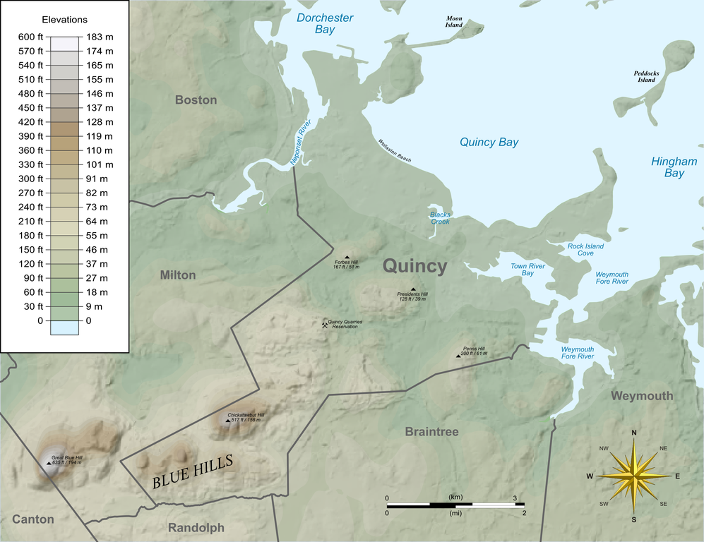
English: Relief map of Quincy, Massachusetts showing features and elevations. |
| Date | |
| Source |
Own work by uploader, using Quantum GIS, Inkscape and Gimp based on public data from Office of Geographic and Environmental Information (MassGIS), Commonwealth of Massachusetts Executive Office of Environmental Affairs - http://www.mass.gov/mgis/dd-over.htm Cette image matricielle PNG a été créée avec QGIS Cette image matricielle PNG a été créée avec Inkscape . Cette image matricielle PNG a été créée avec GIMP. |
| Auteur | Sswonk |
| Lieu de la prise de vue | | Voir cet endroit et d’autres images sur : OpenStreetMap |
|---|
Conditions d’utilisation
| Moi, propriétaire des droits d’auteur sur cette œuvre, la place dans le domaine public. Ceci s'applique dans le monde entier. Dans certains pays, ceci peut ne pas être possible ; dans ce cas : J’accorde à toute personne le droit d’utiliser cette œuvre dans n’importe quel but, sans aucune condition, sauf celles requises par la loi. |
Historique du fichier
Cliquer sur une date et heure pour voir le fichier tel qu'il était à ce moment-là.
| Date et heure | Vignette | Dimensions | Utilisateur | Commentaire | |
|---|---|---|---|---|---|
| actuel | 16 octobre 2009 à 16:06 | | 2 371 × 1 826 (893 kio) | Sswonk | Fix water background alpha |
| 16 octobre 2009 à 16:05 |  | 2 371 × 1 826 (1,02 Mio) | Sswonk | Addition of Quincy Quarries Reservation; Wollaston Beach; Forbes, Penns, and Presidents Hills | |
| 7 juin 2009 à 22:35 |  | 2 371 × 1 826 (1,29 Mio) | Sswonk | {{Information |Description={{en|1=Relief map of Quincy, Massachusetts showing features and elevations.}} |Source=Own work by uploader, using Quantum GIS, Inkscape and Gimp based on public data from Office of Geographic and Environmental Information (MassG |
Utilisation du fichier
Les 3 pages suivantes utilisent ce fichier :
Usage global du fichier
Les autres wikis suivants utilisent ce fichier :
- Utilisation sur en.wikipedia.org
- Utilisation sur ja.wikipedia.org