Fichier:Pedro De Valdivia Siedlungen in Chile 1540 bis 1553.jpg
Taille de cet aperçu : 187 × 600 pixels. Autre résolution : 300 × 962 pixels.
Fichier d’origine (300 × 962 pixels, taille du fichier : 268 kio, type MIME : image/jpeg)
Ce fichier et sa description proviennent de Wikimedia Commons.

|
Cette image (de type historical map) devrait être recréée dans un format vectoriel, en tant que fichier SVG. Cela offrirait plusieurs avantages : voir Commons:Media for cleanup pour plus d'informations. Si une version SVG de cette image est déjà disponible, merci de bien vouloir l'envoyer. Après cela, remplacez ce modèle par {{vector version available|nouveau nom d'image.svg}}.
|


| Description |
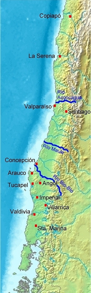
Deutsch: Karte von Chile. Pedro de Valdivia. Koloniale Siedlungen in Chile, 1540 - 1553
English: Map of Chile. Pedro de Valdivia. Locations of colonization in Chile, 1540 - 1553
Español: Mapa de Chile. Pedro de Valdivia. Fundaciones en Chile, 1540 - 1553 |
| Date | (UTC) |
| Source | |
| Auteur |
|
| Autres versions | العربيَّة |
| Cette image a été retouchée, ce qui signifie qu'elle a été modifiée par ordinateur et est différente de l'image d'origine. Liste des modifications : Orte eingezeichnet/locations added. L'image d'origine se trouve ici : Map of Chile Demis.png:
|
This image is in the public domain because it came from the site https://www.demis.nl/products/web-map-server/examples/ and was released by the copyright holder. Permission is granted to copy, distribute and/or modify this map since it is based on free of copyright images from: www.demis.nl. See also approval email on de.wp and its clarification.
|
| This work has been released into the public domain by its copyright holder, www.demis.nl. This applies worldwide. Dans certains pays, ceci peut ne pas être possible ; dans ce cas : www.demis.nl accorde à toute personne le droit d’utiliser cette œuvre dans n’importe quel but, sans aucune condition, sauf celles requises par la loi.
|
Journal des téléversements d’origine
This image is a derivative work of the following images:
- Image:Map_of_Chile_Demis.png licensed with PD-Demis
- 2006-12-20T19:50:53Z Mats Halldin 343x1458 (269160 Bytes) Map of [[Chile]] Bounding box West -78°, South -57°, East -66°, North -16°. Center at {{coor d|36.50000|S|72.00000|W|scale:24600000}}. {{demis-pd}} [[category:maps of Chile]]
Téléversé avec derivativeFX
Historique du fichier
Cliquer sur une date et heure pour voir le fichier tel qu'il était à ce moment-là.
| Date et heure | Vignette | Dimensions | Utilisateur | Commentaire | |
|---|---|---|---|---|---|
| actuel | 20 juillet 2008 à 20:23 | 300 × 962 (268 kio) | WeHaKa | {{Information |Description= {{de|Karte von Chile. Pedro de Valdivia. Koloniale Siedlungen in Chile, 1540 - 1553}} {{en|Map of Chile. Pedro de Valdivia. Locations of colonization in Chile, 1540 - 1553}} {{es|Mapa de Chile. Pedro de Valdivia. Fu |
Utilisation du fichier
La page suivante utilise ce fichier :
Usage global du fichier
Les autres wikis suivants utilisent ce fichier :
- Utilisation sur ar.wikipedia.org
- Utilisation sur ca.wikipedia.org
- Utilisation sur de.wikipedia.org
- Utilisation sur en.wikipedia.org
- Utilisation sur es.wikipedia.org
- Utilisation sur fi.wikipedia.org
- Utilisation sur uk.wikipedia.org
- Utilisation sur www.wikidata.org