Fichier:Patras 1772.jpg

Taille de cet aperçu : 800 × 509 pixels. Autres résolutions : 320 × 204 pixels | 640 × 407 pixels | 1 051 × 669 pixels.
Fichier d’origine (1 051 × 669 pixels, taille du fichier : 33 kio, type MIME : image/jpeg)
Ce fichier et sa description proviennent de Wikimedia Commons.
Description
| Description |
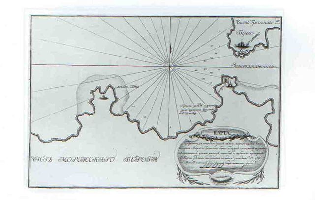
English: This is chart of the channel at the entrance to the Gulf of Corinth. Chart of the Channel leading into the gulf of Lepanto between the northern part of Moreas Peninsula and the Greek coast, drawn after bearings taken from the russian ships anchored therein, with depths measured. The charthas been complied with compass with western variation of 15.00. Scale in sazhens of 7-feet measure of English feet. Scale about 1:210000. The chart was made by russian navy during russo-turkish war 1769-1774. The place Battle of Patras is signed on the chart.
Русский: Это карта пролива между Патраским и Коринфским заливами. Карта пролива в Лепантской залив между северной частью полуострова Морея и Греческим берегом, положен с пеленгов взятых у стоявших у оного на якоре судов и промерены глубины. Глубины указаны в саженях семифутовой меры английского фута. Место Патрасского сражения 1772 года указано надписью. |
| Date | |
| Source | http://www.indrik.ru/catalogue/1997/Atlas_archipelagus.shtml |
| Auteur | Auteur inconnu |
Conditions d’utilisation
|
Cette œuvre est également dans le domaine public dans tous les pays pour lesquels le droit d’auteur a une durée de vie de 100 ans ou moins après la mort de l’auteur. | |
| Ce fichier a été identifié comme étant exempt de restrictions connues liées au droit d’auteur, y compris tous les droits connexes et voisins. | |
Historique du fichier
Cliquer sur une date et heure pour voir le fichier tel qu'il était à ce moment-là.
| Date et heure | Vignette | Dimensions | Utilisateur | Commentaire | |
|---|---|---|---|---|---|
| actuel | 2 décembre 2010 à 16:46 | | 1 051 × 669 (33 kio) | Kontiger | {{Information |Description={{en|1=This is chart of the channel at the entrance to the Gulf of Corinth. Chart of the Channel leading into the gulf of Lepanto between the northern part of Moreas Peninsula and the Greek coast, drawn after bearings taken from |
Utilisation du fichier
La page suivante utilise ce fichier :
Usage global du fichier
Les autres wikis suivants utilisent ce fichier :
- Utilisation sur ru.wikipedia.org
- Utilisation sur uk.wikipedia.org