Fichier:PIA17931 Martian Valley May Be Curiosity's Route, Figure 1.jpg

Fichier d’origine (9 071 × 2 287 pixels, taille du fichier : 18,15 Mio, type MIME : image/jpeg)
Ce fichier et sa description proviennent de Wikimedia Commons.
Description
| Description |
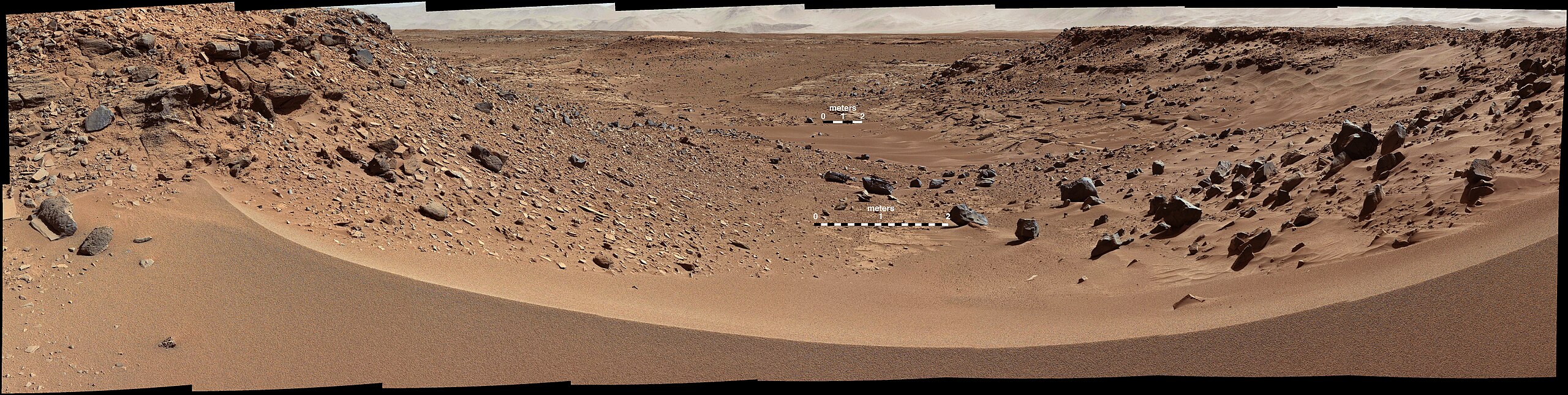
English: This view combines several frames taken by the Mast Camera (Mastcam) on NASA's Mars rover Curiosity, looking into a valley to the west from the eastern side of a dune at the eastern end of the valley. The team operating Curiosity has chosen this valley as a likely route toward mid-term and long-term science destinations. The foreground dune, at a location called "Dingo Gap," is about 3 feet (1 meter) high in the middle and tapered at south and north ends onto low scarps on either side of the gap.
The component images were taken by Mastcam's left-eye camera during early afternoon, local solar time, of the 528th Martian day, or sol, of Curiosity's work on Mars (Jan. 30, 2014). The center of the view is about 10 degrees south of straight west. The left edge is about 20 degrees west of straight south. The right edge is northwest. The largest of the dark rocks on the sand in the right half of the scene are about 2 feet (about 60 centimeters) across. The image has been white-balanced to show what the rocks would look like if they were on Earth. A version with two 2-meter (79-inch) scale bars at distances of about 36 feet (11 meters) and 131 feet (40 meters) away from the rover is available as Figure 1. A version with raw color, as recorded by the camera under Martian lighting conditions, is available as Figure 2. NASA's Jet Propulsion Laboratory, a division of the California Institute of Technology, Pasadena, manages the Mars Science Laboratory Project for NASA's Science Mission Directorate, Washington. JPL designed and built the project's Curiosity rover. Malin Space Science Systems, San Diego, built and operates the rover's Mastcam. More information about Curiosity is online at http://www.nasa.gov/msl and http://mars.jpl.nasa.gov/msl/. |
| Date | (published 3 février 2014) |
| Source | Catalog page · Full-res (JPEG · TIFF) |
| Auteur | NASA/JPL-Caltech/MSSS |
| Autres versions |
|
| Position sur Mars | Voir cet endroit et d’autres images sur : Google Maps |
|---|
Cette image ou vidéo a été cataloguée par le Jet Propulsion Lab de la National Aeronautics and Space Administration (NASA) des États-Unis sous Photo ID : PIA17931.Ce bandeau n’indique rien sur le statut de l’œuvre au regard du droit d'auteur. Un bandeau de droit d’auteur est requis. Voir Commons:À propos des licences pour plus d’informations. Autres langues :
|
| This media is a product of the Mars Science Laboratory mission Credit and attribution belongs to the Curiosity rover Mast Camera (Mastcam) team, NASA/JPL-Caltech/MSSS |
Conditions d’utilisation
| Ce fichier provient de la NASA. Sauf exception, les documents créés par la NASA ne sont pas soumis à copyright. Pour plus d'informations, voir la politique de copyright de la NASA. | ||
 |
Attention :
|
Historique du fichier
Cliquer sur une date et heure pour voir le fichier tel qu'il était à ce moment-là.
| Date et heure | Vignette | Dimensions | Utilisateur | Commentaire | |
|---|---|---|---|---|---|
| actuel | 4 février 2014 à 20:39 | 9 071 × 2 287 (18,15 Mio) | Drbogdan | User created page with UploadWizard |
Utilisation du fichier
La page suivante utilise ce fichier :
Usage global du fichier
Les autres wikis suivants utilisent ce fichier :
- Utilisation sur uk.wikipedia.org