Fichier:Overijssel position.svg

Taille de cet aperçu PNG pour ce fichier SVG : 200 × 236 pixels. Autres résolutions : 203 × 240 pixels | 407 × 480 pixels | 651 × 768 pixels | 868 × 1 024 pixels | 1 736 × 2 048 pixels.
Fichier d’origine (Fichier SVG, nominalement de 200 × 236 pixels, taille : 157 kio)
Ce fichier et sa description proviennent de Wikimedia Commons.
Description
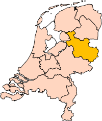
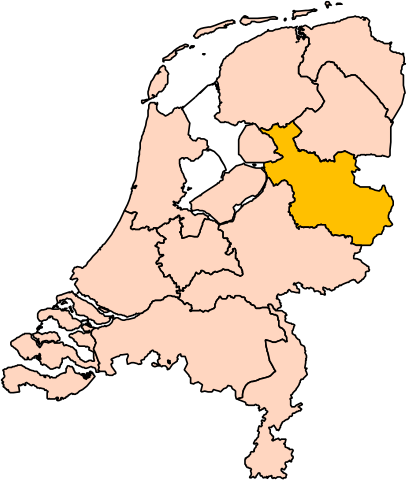
| Description | Location of the province of Overijssel in the Netherlands. |
| Source | Travail personnel |
| Auteur | User:Mtcv |
| Autorisation (Réutilisation de ce fichier) |
Data: attribution required; my work: PD |
| Autres versions | I attempted to make an svg version of Image:Overijssel-Position.png (with less simplified boundaries) |
Clickable version

Conditions d’utilisation

|
Le détenteur des droits d’auteur de ce fichier, Centraal Bureau voor de Statistiek, autorise n’importe qui à l’utiliser pour n’importe quelle utilisation, pourvu que le détenteur des droits d’auteur soit correctement attribué. La redistribution, les œuvres dérivées, l’utilisation commerciale et toutes les autres utilisations sont autorisées. |
Attribution:
|
| Annotations | Cette image est annotée : Voir les annotations sur Wikimedia Commons |


Historique du fichier
Cliquer sur une date et heure pour voir le fichier tel qu'il était à ce moment-là.
| Date et heure | Vignette | Dimensions | Utilisateur | Commentaire | |
|---|---|---|---|---|---|
| actuel | 2 mars 2019 à 19:20 | | 200 × 236 (157 kio) | Thayts | update |
| 3 octobre 2006 à 02:44 |  | 200 × 236 (158 kio) | Mtcv | {{Information| |Description=Location of the province of Noord-Holland (North Holland) in the Netherlands. |Source=Own work, based on freely available GIS data |Date=2006-10-03 |Author=User:Mtcv |Permission=Data: attribution required; my work: PD |othe |
Utilisation du fichier
Aucune page n’utilise ce fichier.
Usage global du fichier
Les autres wikis suivants utilisent ce fichier :
- Utilisation sur ar.wikipedia.org
- أفريسل
- زفوله
- ديفينتر
- تفنتة
- قالب:بلديات أوفرآيسل
- هينجيلو
- ألميلو
- هاكسبيرخن
- بورنه (أوفرآيسل)
- أنسخديه
- قالب:مناطق أوفرآيسل
- دالفسن
- صلند
- دينكللاند
- هاردنبيرخ
- هيليندورن
- هوف فان تفنته
- كامبن (هولندا)
- كوب فان أوفرآيسل
- لوسر (هولندا)
- أولدنزال
- أولست- فايه
- أومين (هولندا)
- رالته
- رايسن- هولتن
- ستابهورست
- ستينفايكرلاند
- توبيرخن
- تفنتاراند
- فيردن (هولندا)
- زفارتافاترلاند
- Utilisation sur be-tarask.wikipedia.org
- Utilisation sur cy.wikipedia.org
- Utilisation sur en.wikipedia.org
Voir davantage sur l’utilisation globale de ce fichier.