Fichier:Ogallala saturated thickness 1997-sattk97-v2.svg

Taille de cet aperçu PNG pour ce fichier SVG : 410 × 600 pixels. Autres résolutions : 164 × 240 pixels | 328 × 480 pixels | 525 × 768 pixels | 700 × 1 024 pixels | 1 399 × 2 048 pixels | 656 × 960 pixels.
Fichier d’origine (Fichier SVG, nominalement de 656 × 960 pixels, taille : 1,36 Mio)
Ce fichier et sa description proviennent de Wikimedia Commons.
Description
| Description |
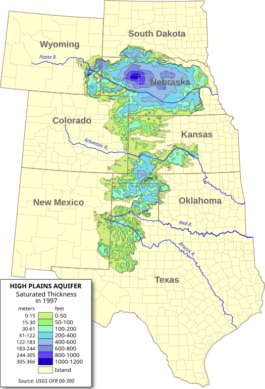
English: Digital map of the saturated thickness of the High Plains aquifer in parts of Kansas, Nebraska, New Mexico, Oklahoma, South Dakota, Texas and Wyoming, 1996-97.
Produced from GIS data produced by the USGS and published in Open File Report 00-300 (USGS OFR 00-300)[1]. Researchers: Fischer, Brian C.; Kollasch, Keith M.; McGuire, Virginia L. |
| Date | |
| Source | Travail personnel |
| Auteur | Kbh3rd |
| Autres versions |
 |
Conditions d’utilisation
Moi, en tant que détenteur des droits d’auteur sur cette œuvre, je la publie sous les licences suivantes :
Ce fichier est disponible selon les termes de la licence Creative Commons Attribution – Partage dans les Mêmes Conditions 3.0 (non transposée).
- Vous êtes libre :
- de partager – de copier, distribuer et transmettre cette œuvre
- d’adapter – de modifier cette œuvre
- Sous les conditions suivantes :
- paternité – Vous devez donner les informations appropriées concernant l'auteur, fournir un lien vers la licence et indiquer si des modifications ont été faites. Vous pouvez faire cela par tout moyen raisonnable, mais en aucune façon suggérant que l’auteur vous soutient ou approuve l’utilisation que vous en faites.
- partage à l’identique – Si vous modifiez, transformez, ou vous basez sur cette œuvre, vous devez distribuer votre contribution sous la même licence ou une licence compatible avec celle de l’original.

|
Vous avez la permission de copier, distribuer et modifier ce document selon les termes de la GNU Free Documentation License version 1.2 ou toute version ultérieure publiée par la Free Software Foundation, sans sections inaltérables, sans texte de première page de couverture et sans texte de dernière page de couverture. Un exemplaire de la licence est inclus dans la section intitulée GNU Free Documentation License. |
Vous pouvez choisir l’une de ces licences.
Historique du fichier
Cliquer sur une date et heure pour voir le fichier tel qu'il était à ce moment-là.
| Date et heure | Vignette | Dimensions | Utilisateur | Commentaire | |
|---|---|---|---|---|---|
| actuel | 31 juillet 2009 à 08:56 | | 656 × 960 (1,36 Mio) | Kbh3rd | Removed labels from paths so they should render properly with the wikimedia software. :( |
| 31 juillet 2009 à 01:38 |  | 656 × 960 (1,36 Mio) | Kbh3rd | {{Information |Description={{en|1=Digital map of the saturated thickness of the High Plains aquifer in parts of Kansas, Nebraska, New Mexico, Oklahoma, [[:en:Sout |
Utilisation du fichier
La page suivante utilise ce fichier :
Usage global du fichier
Les autres wikis suivants utilisent ce fichier :
- Utilisation sur ar.wikipedia.org
- Utilisation sur de.wikipedia.org
- Utilisation sur en.wikipedia.org
- Utilisation sur eo.wikipedia.org
- Utilisation sur es.wikipedia.org
- Utilisation sur fi.wikipedia.org
- Utilisation sur ko.wikipedia.org
- Utilisation sur ml.wikipedia.org
- Utilisation sur www.wikidata.org
- Utilisation sur zh.wikipedia.org