Fichier:Official LanguagesMap-Africa.png
Pas de plus haute résolution disponible.
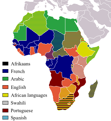
Official_LanguagesMap-Africa.png (360 × 392 pixels, taille du fichier : 21 kio, type MIME : image/png)
Ce fichier et sa description proviennent de Wikimedia Commons.

|
Une version vectorielle de cette image existe, dans le format « SVG ». Si elle n’est pas inférieure, elle devrait être utilisée à la place de la présente version pour des affichages en plus grandes dimensions ou nécessitant une meilleure résolution.
File:Official LanguagesMap-Africa.png → File:Official LanguagesMap-Africa.svg
Pour plus d’informations sur les images vectorielles, consultez la page de transition de Commons vers le format SVG. Voir aussi les informations à propos de la manière dont le logiciel MediaWiki gère les images au format SVG. |
 |
Taken from Image:BlankMap-Africa.png. Information from http://www.nationsonline.org/oneworld/index.html and CIA World Factbook
| Moi, propriétaire des droits d’auteur sur cette œuvre, la place dans le domaine public. Ceci s'applique dans le monde entier. Dans certains pays, ceci peut ne pas être possible ; dans ce cas : J’accorde à toute personne le droit d’utiliser cette œuvre dans n’importe quel but, sans aucune condition, sauf celles requises par la loi. |
Other version
-
 Afrikaans
 -
 Français


Historique du fichier
Cliquer sur une date et heure pour voir le fichier tel qu'il était à ce moment-là.
| Date et heure | Vignette | Dimensions | Utilisateur | Commentaire | |
|---|---|---|---|---|---|
| actuel | 16 mars 2018 à 20:05 | | 360 × 392 (21 kio) | Maphobbyist | Updates |
| 6 mai 2008 à 14:54 |  | 746 × 813 (250 kio) | Ant75 | Updated Madagascar to English, French and Traditional African following 2007 Constitution. | |
| 1 mai 2008 à 14:54 |  | 720 × 784 (186 kio) | Ant75 | Updated Sudan to English and Arabic following 2005 Constitution. | |
| 16 mars 2007 à 21:59 |  | 360 × 392 (14 kio) | Rasulo~commonswiki | Updated earlier version due to officialization of Swahili in Uganda. Also corrected the language status of Zimbabwe where Shona and Ndebele are currently co-official with English. | |
| 19 mai 2005 à 19:05 |  | 360 × 392 (14 kio) | Rydia~commonswiki | Taken from Image:BlankMap-Africa.png. Information from http://www.nationsonline.org/oneworld/index.html and CIA World Factbook {{PD}} |
Utilisation du fichier
Aucune page n’utilise ce fichier.
Usage global du fichier
Les autres wikis suivants utilisent ce fichier :
- Utilisation sur ca.wikipedia.org
- Utilisation sur de.wikipedia.org
- Utilisation sur he.wikivoyage.org
- Utilisation sur kg.wikipedia.org
- Utilisation sur oc.wikipedia.org
- Utilisation sur pam.wikipedia.org