Fichier:OHMap-doton-Kings Mills.png
Pas de plus haute résolution disponible.
OHMap-doton-Kings_Mills.png (309 × 352 pixels, taille du fichier : 17 kio, type MIME : image/png)
Ce fichier et sa description proviennent de Wikimedia Commons.
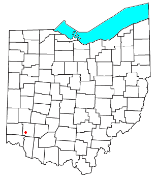
| Description | Locator map of the unincorporated community of Kings Mills in Warren County, Ohio, United States. | ||
| Date | |||
| Source | Modified from this United States Census Bureau file. | ||
| Auteur | User:Nyttend | ||
| Autorisation (Réutilisation de ce fichier) |
US Government work is public domain, and my work is
|
Historique du fichier
Cliquer sur une date et heure pour voir le fichier tel qu'il était à ce moment-là.
| Date et heure | Vignette | Dimensions | Utilisateur | Commentaire | |
|---|---|---|---|---|---|
| actuel | 13 octobre 2007 à 16:48 | | 309 × 352 (17 kio) | Nyttend | {{Information |Description=Locator map of the {{w|unincorporated area|unincorporated community}} of {{w|Kings Mills, Ohio|Kings Mills}} in {{w|Warren County, Ohio|Warren County}}, {{w|Ohio}}, {{w|United States}}. |Source=Modified from [http://www2.census. |
Utilisation du fichier
La page suivante utilise ce fichier :
Usage global du fichier
Les autres wikis suivants utilisent ce fichier :
- Utilisation sur en.wikipedia.org
- Utilisation sur fa.wikipedia.org
- Utilisation sur pt.wikipedia.org
- Utilisation sur tt.wikipedia.org
- Utilisation sur www.wikidata.org