Fichier:Nova Scotia municipalities.png
Taille de cet aperçu : 698 × 600 pixels. Autres résolutions : 279 × 240 pixels | 559 × 480 pixels | 894 × 768 pixels | 1 192 × 1 024 pixels | 2 550 × 2 191 pixels.
Fichier d’origine (2 550 × 2 191 pixels, taille du fichier : 126 kio, type MIME : image/png)
Ce fichier et sa description proviennent de Wikimedia Commons.
Description
| Description |
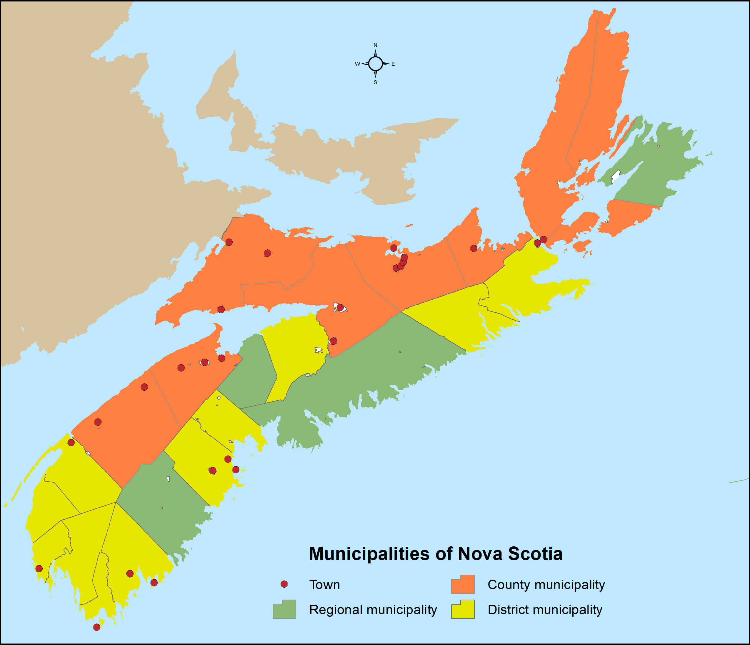
English: Distribution of Nova Scotia's 49 municipalities (4 regional municipalities, 9 county municipalities, 12 district municipalities and 25 towns) utilizing Statistics Canada's 2016 census subdivision boundaries. |
| Date | |
| Source | Travail personnel |
| Auteur | Hwy43 |
Conditions d’utilisation
Moi, en tant que détenteur des droits d’auteur sur cette œuvre, je la publie sous la licence suivante :
Ce fichier est disponible selon les termes de la licence Creative Commons Attribution 3.0 Non transposée.
- Vous êtes libre :
- de partager – de copier, distribuer et transmettre cette œuvre
- d’adapter – de modifier cette œuvre
- Sous les conditions suivantes :
- paternité – Vous devez donner les informations appropriées concernant l'auteur, fournir un lien vers la licence et indiquer si des modifications ont été faites. Vous pouvez faire cela par tout moyen raisonnable, mais en aucune façon suggérant que l’auteur vous soutient ou approuve l’utilisation que vous en faites.
Historique du fichier
Cliquer sur une date et heure pour voir le fichier tel qu'il était à ce moment-là.
| Date et heure | Vignette | Dimensions | Utilisateur | Commentaire | |
|---|---|---|---|---|---|
| actuel | 31 juillet 2021 à 21:20 | | 2 550 × 2 191 (126 kio) | Hwy43 | Revise to reflect the amalgamation of the Town of Windsor with the Municipality of the District of West Hants to form a new regional municipality named West Hants Regional Municipality.en |
| 28 décembre 2016 à 11:00 |  | 816 × 701 (31 kio) | Hwy43 | Reflect the dissolution of the former Town of Parrsboro | |
| 8 décembre 2016 à 10:05 |  | 816 × 701 (31 kio) | Hwy43 | return accidentally dissolved district municipality boundaries and fix background colour for Prince Edward Island | |
| 7 décembre 2016 à 04:20 |  | 816 × 701 (30 kio) | Hwy43 | hide dissolved towns of Canso and Hantsport and reveal Indian reserves | |
| 2 janvier 2016 à 05:22 |  | 3 400 × 2 921 (198 kio) | Hwy43 | remove towns dissolved since 2011 census | |
| 2 janvier 2016 à 01:05 |  | 3 400 × 2 921 (201 kio) | Hwy43 | Display only those nine historical counties that are incorporated as county municipalities (with symbology changes). | |
| 1 janvier 2016 à 22:00 |  | 3 400 × 2 921 (241 kio) | Hwy43 | User created page with UploadWizard |
Utilisation du fichier
Aucune page n’utilise ce fichier.
Usage global du fichier
Les autres wikis suivants utilisent ce fichier :
- Utilisation sur en.wikipedia.org