Fichier:Northern Mali conflict.svg

Taille de cet aperçu PNG pour ce fichier SVG : 629 × 600 pixels. Autres résolutions : 252 × 240 pixels | 503 × 480 pixels | 805 × 768 pixels | 1 074 × 1 024 pixels | 2 148 × 2 048 pixels | 1 316 × 1 255 pixels.
Fichier d’origine (Fichier SVG, nominalement de 1 316 × 1 255 pixels, taille : 796 kio)
Ce fichier et sa description proviennent de Wikimedia Commons.
Description
| Description |
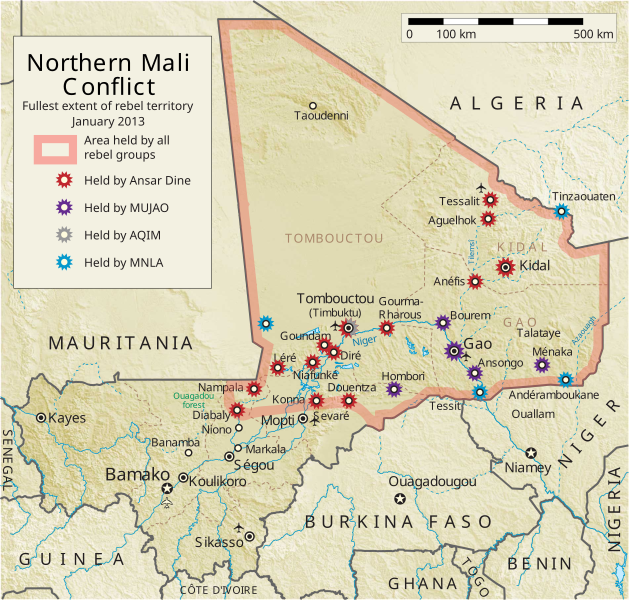
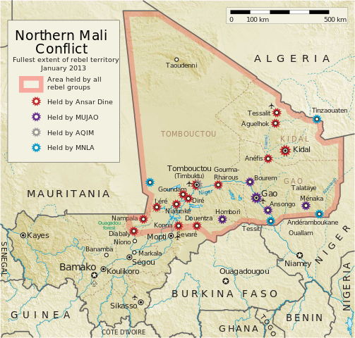
English: Map of the conflict in Northern Mali. (English)
العربية: خريطة الصّراع في شمال مالي. (إنجليزي)
Français : Carte du conflit au nord du Mali. (Anglais)
Latina: Charta rebellionis Tuaregorum in Malia septentrionali. (Anglice)
Українська: Карта конфлікту на півночі Малі. (Англійською) |
| Source |
Travail personnel Cette image vectorielle contient des éléments, éventuellement modifiés, qui ont été extraits de : Cette image vectorielle contient des éléments, éventuellement modifiés, qui ont été extraits de : |
| Auteur | Orionist |
| Autres versions | German/Deutsch/Allemand, French/Français, Macedonian/македонски јазик/Macédonien |
| SVG information | Le code de ce fichier SVG n'est pas valide en raison de 14 erreurs. Cette carte W3C-invalide a été créée avec Adobe Illustrator, et avec Inkscape. Cette carte SVG utilise du texte encapsulé qui peut être traduit facilement à l'aide d'un éditeur de texte. |
Notes
- ↑ US Department of State, "Country Reports on Terrorism 2011", Chapter 2 Country Reports: Africa Overview, 31 July 2012
Conditions d’utilisation
Moi, en tant que détenteur des droits d’auteur sur cette œuvre, je la publie sous la licence suivante :
Ce fichier est disponible selon les termes de la licence Creative Commons Attribution – Partage dans les Mêmes Conditions 3.0 (non transposée).
- Vous êtes libre :
- de partager – de copier, distribuer et transmettre cette œuvre
- d’adapter – de modifier cette œuvre
- Sous les conditions suivantes :
- paternité – Vous devez donner les informations appropriées concernant l'auteur, fournir un lien vers la licence et indiquer si des modifications ont été faites. Vous pouvez faire cela par tout moyen raisonnable, mais en aucune façon suggérant que l’auteur vous soutient ou approuve l’utilisation que vous en faites.
- partage à l’identique – Si vous modifiez, transformez, ou vous basez sur cette œuvre, vous devez distribuer votre contribution sous la même licence ou une licence compatible avec celle de l’original.
Historique du fichier
Cliquer sur une date et heure pour voir le fichier tel qu'il était à ce moment-là.
| Date et heure | Vignette | Dimensions | Utilisateur | Commentaire | |
|---|---|---|---|---|---|
| actuel | 8 avril 2014 à 08:59 | | 1 316 × 1 255 (796 kio) | Ansh666 | Reverted to version as of 16:51, 8 March 2013 - restoring the correct version, as the map is supposed to be historical, not current |
| 5 décembre 2013 à 22:15 |  | 1 316 × 1 255 (699 kio) | Hanibal911 | more accurately reflects the situation | |
| 8 mars 2013 à 18:51 |  | 1 316 × 1 255 (796 kio) | Agricolae | Hombori dot restored | |
| 5 mars 2013 à 16:29 |  | 1 316 × 1 255 (794 kio) | TUFKAAP | Since this is an English map, Al-Qaeda in the Islamic Maghreb should be abbreviated as AQIM. | |
| 11 février 2013 à 05:33 |  | 1 316 × 1 255 (794 kio) | Agricolae | shift text distorted on upload | |
| 11 février 2013 à 05:27 |  | 1 316 × 1 255 (794 kio) | Agricolae | change to show greatest extent - see WP Talk:Northern Mali conflict (2012–present) | |
| 8 février 2013 à 08:36 |  | 1 316 × 1 255 (699 kio) | Rama | Aguelhok contested or taken ( http://www.lemonde.fr/afrique/article/2013/02/08/mali-les-forces-francaise-et-tchadiennes-a-aguelhok_1828906_3212.html ) | |
| 2 février 2013 à 12:29 |  | 1 316 × 1 255 (698 kio) | U5K0 | Bourem to green as per talk page | |
| 30 janvier 2013 à 10:41 |  | 1 316 × 1 255 (679 kio) | Orionist | Updated map: Menaka, Anderamboukane, Ansongo, Dire, Kidal and other MNLA positions. Removed rebel area boundaries as the situation has become complicated. | |
| 29 janvier 2013 à 19:23 |  | 1 316 × 1 255 (894 kio) | Jaybear | Insertion of a map-scale in the upper right corner (added directly before the token "/svg" at end of svg-code); |
Utilisation du fichier
Aucune page n’utilise ce fichier.
Usage global du fichier
Les autres wikis suivants utilisent ce fichier :
- Utilisation sur af.wikipedia.org
- Utilisation sur ar.wikipedia.org
- Utilisation sur azb.wikipedia.org
- Utilisation sur az.wikipedia.org
- Utilisation sur bg.wikipedia.org
- Utilisation sur bn.wikipedia.org
- Utilisation sur ca.wikipedia.org
- Utilisation sur cs.wikipedia.org
- Utilisation sur cy.wikipedia.org
- Utilisation sur da.wikipedia.org
- Utilisation sur de.wikipedia.org
- Utilisation sur el.wikipedia.org
- Utilisation sur en.wikipedia.org
- Mali
- Portal:Mali
- Insurgency in the Maghreb (2002–present)
- War on terror
- User:Orionist/Gallery
- National Movement for the Liberation of Azawad
- Wikipedia talk:WikiProject Maps/Archive 2012
- Wikipedia:In the news/Candidates/April 2012
- Wikipedia:Graphics Lab/Map workshop/Archive/Apr 2012
- Wikipedia:Wikipedia Signpost/2012-04-30/WikiProject report
- Wikipedia:Wikipedia Signpost/Single/2012-04-30
- Mali War
- Wikipedia:WikiProject Maps/Conventions/Pushpin maps
- Operation Serval
- Chadian intervention in northern Mali
- Islamist insurgency in the Sahel
- User:AlbanianEditor1990/sandbox
- Utilisation sur en.wikinews.org
- Utilisation sur eo.wikipedia.org
- Utilisation sur es.wikipedia.org
- Utilisation sur et.wikipedia.org
- Utilisation sur eu.wikipedia.org
- Utilisation sur fi.wikipedia.org
Voir davantage sur l’utilisation globale de ce fichier.