Fichier:North ossetia map.png
Pas de plus haute résolution disponible.
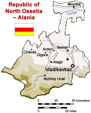
North_ossetia_map.png (304 × 377 pixels, taille du fichier : 23 kio, type MIME : image/png)
Ce fichier et sa description proviennent de Wikimedia Commons.

Map of North Ossetia, Russia (from mapping by US Dept of State - 2762 6-94 STATE (INR/GGI))
Originally uploaded to English Wikipedia by ChrisO.
| This image is a work of a United States Department of State employee, taken or made as part of that person's official duties. As a work of the U.S. federal government, the image is in the public domain per 17 U.S.C. § 101 and § 105 and the Department Copyright Information. |  |
Historique du fichier
Cliquer sur une date et heure pour voir le fichier tel qu'il était à ce moment-là.
| Date et heure | Vignette | Dimensions | Utilisateur | Commentaire | |
|---|---|---|---|---|---|
| actuel | 6 avril 2005 à 15:50 | | 304 × 377 (23 kio) | Dbenbenn | Reverted to earlier revision |
| 6 avril 2005 à 15:50 |  | 300 × 330 (39 kio) | Dbenbenn | original version, uploaded by en:User:ChrisO at 12:19, 1 Sep 2004 | |
| 29 mars 2005 à 14:51 |  | 304 × 377 (23 kio) | Fbd~commonswiki | Image from the en.wikipedia. {{PD-USGov}} |
Utilisation du fichier
La page suivante utilise ce fichier :
Usage global du fichier
Les autres wikis suivants utilisent ce fichier :
- Utilisation sur ar.wikipedia.org
- Utilisation sur bn.wikipedia.org
- Utilisation sur ceb.wikipedia.org
- Utilisation sur cy.wikipedia.org
- Utilisation sur da.wikipedia.org
- Utilisation sur de.wikipedia.org
- Utilisation sur en.wikinews.org
- Utilisation sur es.wikipedia.org
- Utilisation sur fa.wikipedia.org
- Utilisation sur he.wikipedia.org
- Utilisation sur hi.wikipedia.org
- Utilisation sur hr.wikipedia.org
- Utilisation sur id.wikipedia.org
- Utilisation sur io.wikipedia.org
- Utilisation sur is.wikipedia.org
- Utilisation sur it.wikipedia.org
- Utilisation sur ja.wikipedia.org
- Utilisation sur jv.wikipedia.org
- Utilisation sur ka.wiktionary.org
- Utilisation sur ko.wikipedia.org
- Utilisation sur mk.wikipedia.org
- Utilisation sur nl.wikipedia.org
- Utilisation sur nn.wikipedia.org
- Utilisation sur no.wikipedia.org
- Utilisation sur pt.wikipedia.org
- Utilisation sur sh.wikipedia.org
- Utilisation sur sr.wikipedia.org
- Utilisation sur tr.wikipedia.org
- Utilisation sur vep.wikipedia.org
- Utilisation sur zh-min-nan.wikipedia.org
- Utilisation sur zh.wikipedia.org
Voir davantage sur l’utilisation globale de ce fichier.