Fichier:Nexco Systems Map.svg

Taille de cet aperçu PNG pour ce fichier SVG : 663 × 600 pixels. Autres résolutions : 265 × 240 pixels | 531 × 480 pixels | 849 × 768 pixels | 1 132 × 1 024 pixels | 2 264 × 2 048 pixels | 735 × 665 pixels.
Fichier d’origine (Fichier SVG, nominalement de 735 × 665 pixels, taille : 103 kio)
Ce fichier et sa description proviennent de Wikimedia Commons.
Description
| Description |
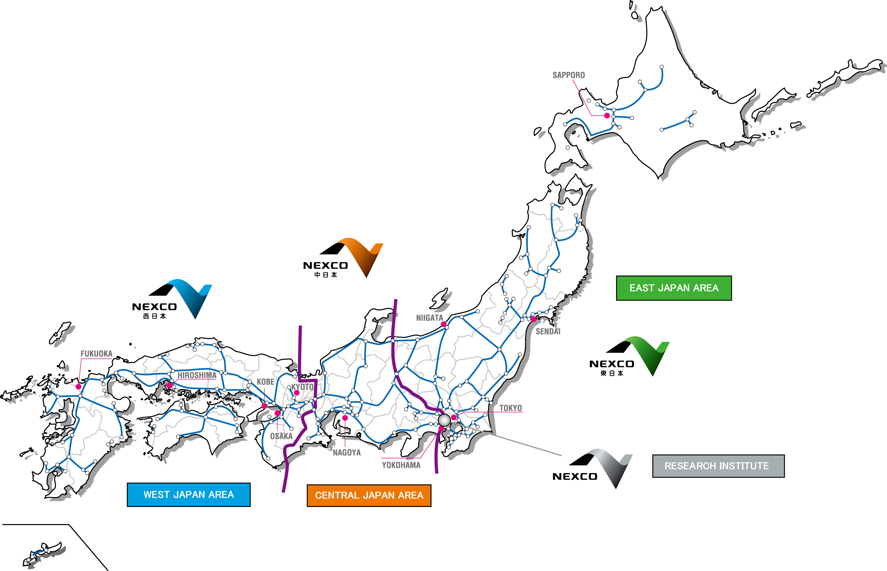
English: Map of the operational territories of the three major expressway companies in Japan, Nexco West, Nexco Central and Nexco East The black lines are prefecture boundaries. |
| Date | |
| Source |
Nexco Research Institute Map of company territories (Archived) Cette image vectorielle contient des éléments, éventuellement modifiés, qui ont été extraits de : Cette image vectorielle contient des éléments, éventuellement modifiés, qui ont été extraits de : Cette image vectorielle contient des éléments, éventuellement modifiés, qui ont été extraits de : Cette image vectorielle contient des éléments, éventuellement modifiés, qui ont été extraits de : |
| Auteur | The Navigators |
| Autres versions | Japan Highway Area.JPG - JPEG version. |
Conditions d’utilisation
| Moi, propriétaire des droits d’auteur sur cette œuvre, la place dans le domaine public. Ceci s'applique dans le monde entier. Dans certains pays, ceci peut ne pas être possible ; dans ce cas : J’accorde à toute personne le droit d’utiliser cette œuvre dans n’importe quel but, sans aucune condition, sauf celles requises par la loi. |

|
Cette œuvre contient des ressources qui peuvent être soumises aux lois des marques dans certaines juridictions. Avant d'utiliser ce contenu, veuillez vous assurer que vous avez le droit de l'utiliser dans le cadre des lois qui s'appliquent aux circonstances dans lesquelles vous comptez l'utiliser. Vous êtes entièrement responsable de vérifier que le droit de marque d'un tiers n'est pas enfreint. Voir les avertissements généraux. Ce bandeau n’indique rien sur le statut de l’œuvre au regard du droit d'auteur. Un bandeau de droit d’auteur est requis. Voir Commons:À propos des licences pour plus d’informations. |
Historique du fichier
Cliquer sur une date et heure pour voir le fichier tel qu'il était à ce moment-là.
| Date et heure | Vignette | Dimensions | Utilisateur | Commentaire | |
|---|---|---|---|---|---|
| actuel | 11 mars 2019 à 02:13 | | 735 × 665 (103 kio) | The Navigators | {{Information |description= {{en|1=Map of the operational territories of the three major expressway companies in Japan, Nexco West, Nexco Central and Nexco East The black lines are prefecture boundaries.}} |date= 10 March 2019 |source= Nexco Research Institute [http://www.ri-nexco.co.jp/Portals/0/images/contents/English/co_prjapan.jpg Map of company terr... |
Utilisation du fichier
Les 2 pages suivantes utilisent ce fichier :
Usage global du fichier
Les autres wikis suivants utilisent ce fichier :
- Utilisation sur en.wikipedia.org
- Utilisation sur ja.wikipedia.org
- Utilisation sur nl.wikipedia.org
- Utilisation sur www.wikidata.org
- Utilisation sur zh.wikipedia.org