Fichier:Narva basin map.svg

Taille de cet aperçu PNG pour ce fichier SVG : 423 × 599 pixels. Autres résolutions : 169 × 240 pixels | 339 × 480 pixels | 542 × 768 pixels | 722 × 1 024 pixels | 1 445 × 2 048 pixels | 743 × 1 053 pixels.
Fichier d’origine (Fichier SVG, nominalement de 743 × 1 053 pixels, taille : 2,46 Mio)
Ce fichier et sa description proviennent de Wikimedia Commons.
Description
| Description |
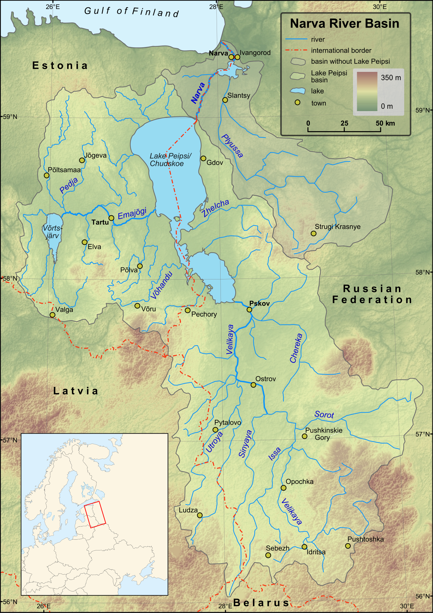
English: Map of Narva River and Lake Peipsi basins. Towns with population over 4000 (according to relevant Wikipedia lists) are included on the map. Terrain: embedded JPG. Projection: UTM Zone 35N |
| Date | |
| Source |
Created in ESRI ArcMap and Inkscape using a map from [1] and some other maps for corrections.
Elevation data from Shuttle Radar Topography Mission. |
| Auteur | Hannu |
| Autres versions | Magyar |
Conditions d’utilisation
| Moi, propriétaire des droits d’auteur sur cette œuvre, la place dans le domaine public. Ceci s'applique dans le monde entier. Dans certains pays, ceci peut ne pas être possible ; dans ce cas : J’accorde à toute personne le droit d’utiliser cette œuvre dans n’importe quel but, sans aucune condition, sauf celles requises par la loi. |
Historique du fichier
Cliquer sur une date et heure pour voir le fichier tel qu'il était à ce moment-là.
| Date et heure | Vignette | Dimensions | Utilisateur | Commentaire | |
|---|---|---|---|---|---|
| actuel | 1 décembre 2009 à 18:43 | | 743 × 1 053 (2,46 Mio) | Hannu~commonswiki | minor updates |
| 28 novembre 2009 à 02:53 |  | 743 × 1 053 (2,44 Mio) | Hannu~commonswiki | : | |
| 28 novembre 2009 à 02:35 |  | 743 × 1 053 (2,44 Mio) | Hannu~commonswiki | text to path | |
| 28 novembre 2009 à 02:19 |  | 743 × 1 053 (2,06 Mio) | Hannu~commonswiki | : | |
| 28 novembre 2009 à 02:14 |  | 743 × 1 053 (2,05 Mio) | Hannu~commonswiki | new map | |
| 14 avril 2009 à 20:53 |  | 738 × 1 004 (959 kio) | Hannu~commonswiki | vector location map | |
| 17 janvier 2009 à 17:28 |  | 738 × 1 004 (957 kio) | Hannu~commonswiki | {{Information |Description={{en|1=Map of Narva River and Lake Peipsi basins.}} |Source=Created in Inkscape using a map from [http://www.ilec.or.jp/eg/lbmi/pdf/20_Lake_Peipsi_Chudskoe_27February2006.pdf]. Location ma | |
| 16 janvier 2009 à 18:18 |  | 738 × 1 004 (639 kio) | Hannu~commonswiki | {{Information |Description={{en|1=Map of Narva River and Lake Peipsi basins.}} |Source=Created in Inkscape using a map from [http://www.ilec.or.jp/eg/lbmi/pdf/20_Lake_Peipsi_Chudskoe_27February2006.pdf]. Minimap mad | |
| 16 janvier 2009 à 18:11 |  | 738 × 1 004 (529 kio) | Hannu~commonswiki | {{Information |Description={{en|1=Map of Narva River and Lake Peipsi basins.}} |Source=Created in Inkscape using a map from [http://www.ilec.or.jp/eg/lbmi/pdf/20_Lake_Peipsi_Chudskoe_27February2006.pdf]. Minimap mad |
Utilisation du fichier
La page suivante utilise ce fichier :
Usage global du fichier
Les autres wikis suivants utilisent ce fichier :
- Utilisation sur af.wikipedia.org
- Utilisation sur als.wikipedia.org
- Utilisation sur ar.wikipedia.org
- Utilisation sur ast.wikipedia.org
- Utilisation sur azb.wikipedia.org
- Utilisation sur be-tarask.wikipedia.org
- Utilisation sur bg.wikipedia.org
- Utilisation sur ca.wikipedia.org
- Utilisation sur cs.wikipedia.org
- Utilisation sur da.wikipedia.org
- Utilisation sur de.wikipedia.org
- Utilisation sur el.wikipedia.org
- Utilisation sur en.wikipedia.org
- Utilisation sur es.wikipedia.org
- Utilisation sur fa.wikipedia.org
- Utilisation sur fi.wikipedia.org
- Luokka:Narvanjoen vesistö
- Velikaja
- Pljussa
- Piusa jõgi
- Narvanjoen vesistöalue
- Luokka:Narvanjoen alue
- Narvanjoen alue
- Janja (Pljussa)
- Ljuta (Pljussa)
- Vjorduga
- Pljussan valuma-alue
- Kureja
- Pihkovanjoki
- Luokka:Velikajan valuma-alue
- Tšerjoha (joki)
- Haanjan ylänkö
- Alūksnen ylänkö
- Želtša
- Velikajan valuma-alue
- Peipsijärven valuma-alue
- Luokka:Peipsijärven valuma-alue
- Peipsijärven alue
- Luokka:Emajoen alue
- Luokka:Võrtsjärven valuma-alue
- Võhandu jõgi
- Emajoen valuma-alue
Voir davantage sur l’utilisation globale de ce fichier.