Fichier:NASA-GNT.jpg
Taille de cet aperçu : 606 × 599 pixels. Autres résolutions : 243 × 240 pixels | 485 × 480 pixels | 640 × 633 pixels.
Fichier d’origine (640 × 633 pixels, taille du fichier : 100 kio, type MIME : image/jpeg)
Ce fichier et sa description proviennent de Wikimedia Commons.
Description
| Description |
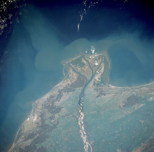
English: With the Ocean on the top portion of the Image, the actual location of the Guntur City should be on the bottom right side portion of the Image.
|
| Date | Prise le 11 janvier 1990, 05:51:41 UTC |
| Source | https://eol.jsc.nasa.gov/searchphotos/photo.pl?mission=STS032&roll=72&frame=61 |
| Auteur | NASA |
| Autres versions |
|

Cette image ou vidéo a été cataloguée par l’un des centres de la National Aeronautics and Space Administration (NASA) des États-Unis sous Photo ID : STS-032-72-61.Ce bandeau n’indique rien sur le statut de l’œuvre au regard du droit d'auteur. Un bandeau de droit d’auteur est requis. Voir Commons:À propos des licences pour plus d’informations. Autres langues :
|
Conditions d’utilisation
| Ce fichier provient de la NASA. Sauf exception, les documents créés par la NASA ne sont pas soumis à copyright. Pour plus d'informations, voir la politique de copyright de la NASA. | ||
 |
Attention :
|
Journal des téléversements d’origine
La page de description originale était ici. Tous les noms d'utilisateur qui suivent se rapportent à en.wikipedia.
Transféré de en.wikipedia à Commons par Kajasudhakarababu utilisant CommonsHelper.
- 2006-05-10 14:25 Gnt 640×633×8 (102625 bytes) Souce: http://eol.jsc.nasa.gov/sseop/EFS/photoinfo.pl?PHOTO=STS032-72-61 From NASA.
Historique du fichier
Cliquer sur une date et heure pour voir le fichier tel qu'il était à ce moment-là.
| Date et heure | Vignette | Dimensions | Utilisateur | Commentaire | |
|---|---|---|---|---|---|
| actuel | 8 juillet 2008 à 16:36 | | 640 × 633 (100 kio) | File Upload Bot (Magnus Manske) | {{BotMoveToCommons|en.wikipedia}} {{Information |Description={{en|Souce: http://eol.jsc.nasa.gov/sseop/EFS/photoinfo.pl?PHOTO=STS032-72-61 From NASA. With the Ocean on the top portion of the Image, the actual location of the '''[[:en:Guntur|Guntur City] |
Utilisation du fichier
La page suivante utilise ce fichier :
Usage global du fichier
Les autres wikis suivants utilisent ce fichier :
- Utilisation sur bn.wikipedia.org
- Utilisation sur en.wikipedia.org
- Utilisation sur es.wikipedia.org
- Utilisation sur sat.wikipedia.org
- Utilisation sur te.wikipedia.org