Fichier:Mount Malinao.jpg
Pas de plus haute résolution disponible.
Mount_Malinao.jpg (640 × 416 pixels, taille du fichier : 43 kio, type MIME : image/jpeg)
Ce fichier et sa description proviennent de Wikimedia Commons.
Description
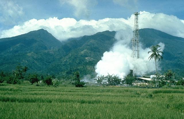
| Description | Mount Malinao is a forested stratovolcano with a summit crater that is breached to the east. The Tiwi geothermal field, seen here with the volcano in the background, is located on the east flanks of Malinao. The geothermal field is located near Luzon's largest fumarole field, which includes siliceous sinter deposits at Naglabong. |
| Date | Date inconnue |
| Source | http://www.volcano.si.edu/world/volcano.cfm?vnum=070304=A&volpage=photos&photo=018037 |
| Auteur | Chris Newhall (U.S. Geological Survey) |
Conditions d’utilisation
Cette image est placée dans le domaine public parce qu'elle contient des éléments issus de l'United States Geological Survey, une agence du Département de l'Intérieur des États-Unis. Pour plus d'information, consultez la politique officielle de copyright de l'USGS (en anglais)
|
Historique du fichier
Cliquer sur une date et heure pour voir le fichier tel qu'il était à ce moment-là.
| Date et heure | Vignette | Dimensions | Utilisateur | Commentaire | |
|---|---|---|---|---|---|
| actuel | 11 octobre 2010 à 20:00 | | 640 × 416 (43 kio) | Michael Metzger | {{Information |Description=Mount Malinao is a forested stratovolcano with a summit crater that is breached to the east. The Tiwi geothermal field, seen here with the volcano in the background, is located on the east flanks of Malinao. The geothermal field |
Utilisation du fichier
Les 2 pages suivantes utilisent ce fichier :
Usage global du fichier
Les autres wikis suivants utilisent ce fichier :
- Utilisation sur arz.wikipedia.org
- Utilisation sur bcl.wikipedia.org
- Utilisation sur cs.wikipedia.org
- Utilisation sur de.wikipedia.org
- Utilisation sur en.wikipedia.org
- Utilisation sur fa.wikipedia.org
- Utilisation sur ilo.wikipedia.org
- Utilisation sur lld.wikipedia.org
- Utilisation sur nl.wikipedia.org
- Utilisation sur www.wikidata.org