Fichier:Mont Saint-Michel, France ESA394286.jpg
Fichier d’origine (5 266 × 4 258 pixels, taille du fichier : 3,71 Mio, type MIME : image/jpeg)
Ce fichier et sa description proviennent de Wikimedia Commons.
Description
| Description |
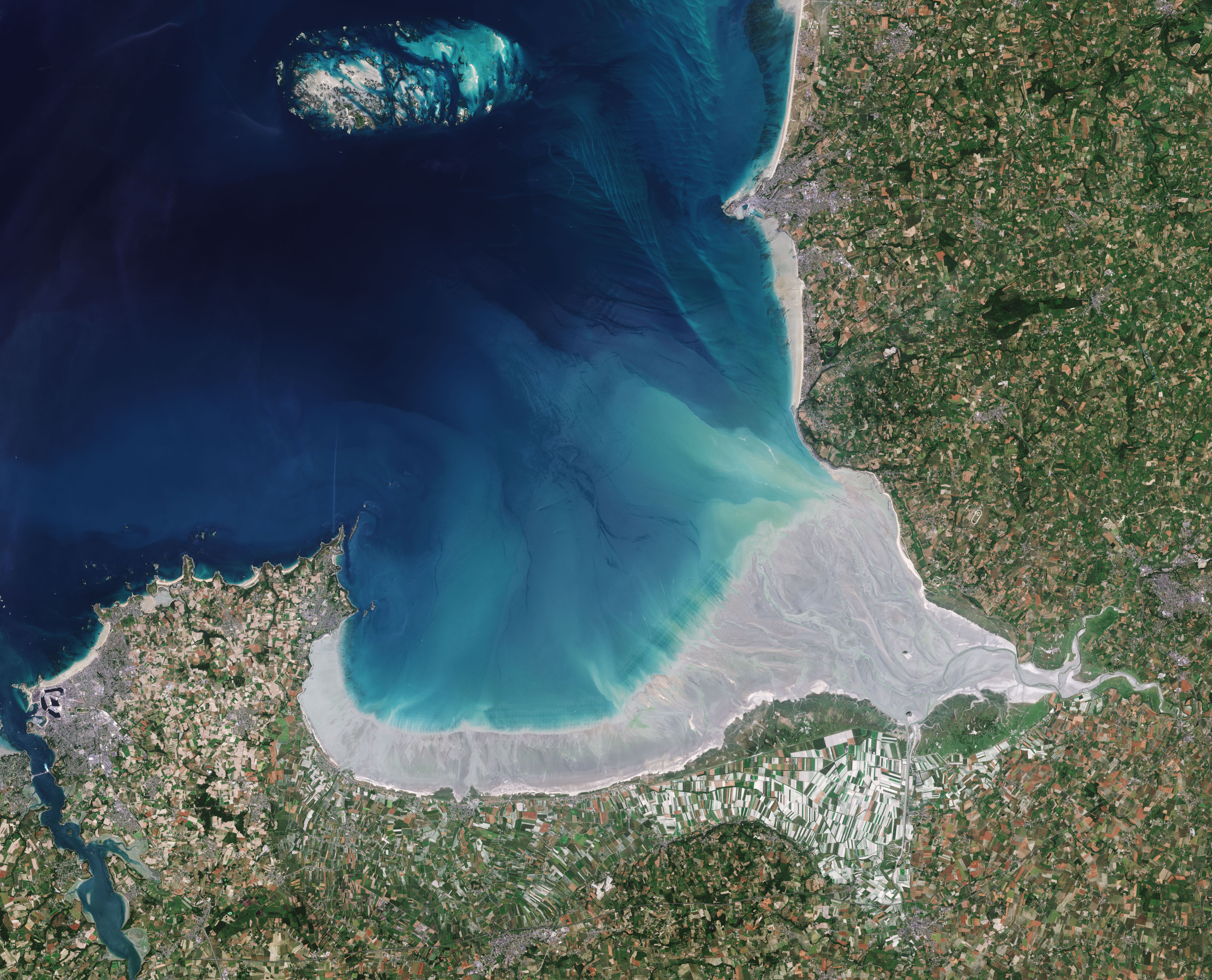
English: The Copernicus Sentinel-2 mission takes us over the Bay of Mont Saint-Michel in northern France.
Lying between Brittany to the west and Normandy to the east, this remarkable bay, which is listed as a UNESCO world heritage site, sees some of the biggest tides in continental Europe. There can be up to 15 m difference between low and high water. When spring tides peak, the sea recedes about 15 km from the coast and when it returns it does so very quickly, making it a dangerous place to be. Sentinel-2 captured this image when the tide was out so that the vast area of sand dunes is exposed cut by meandering channels of shallow water. Three rivers empty into the bay: the Couesnon, the Sée and the Sélune. The famous rocky islet of Mont Saint-Michel, visible as a small dark spot in the south of the bay, is about 1 km from the mouth of the Couesnon. Home to a Benedictine monastery and village, Mont Saint-Michel is also a UNESCO world heritage site and a mecca for tourists. The bay, however, has been prone to silting up in the last couple of centuries. Actions by man, including farming and the building of a causeway to the island monastery, have added to this problem. A major campaign has ensured that Mont-Saint-Michel preserves its maritime character and remains an island. The main river into the bay, the Couesnon, for example, is being left to flow more freely so that sediments are washed out to sea. This image, which was captured on 21 June 2017, is also featured on theEarth from Space video programme. |
| Date | |
| Source | http://www.esa.int/spaceinimages/Images/2018/05/Mont_Saint-Michel_France |
| Auteur | European Space Agency |
| Autorisation (Réutilisation de ce fichier) |
contains modified Copernicus Sentinel data (2017), processed by ESA,CC BY-SA 3.0 IGO |
| Autres versions |
|
| Title | Mont Saint-Michel, France |
| System | Copernicus |
| Set | Earth observation image of the week |
| Location | France |
| Mission | Sentinel-2 |
| Activity | Observing the Earth |

Conditions d’utilisation
- Vous êtes libre :
- de partager – de copier, distribuer et transmettre cette œuvre
- d’adapter – de modifier cette œuvre
- Sous les conditions suivantes :
- paternité – Vous devez donner les informations appropriées concernant l'auteur, fournir un lien vers la licence et indiquer si des modifications ont été faites. Vous pouvez faire cela par tout moyen raisonnable, mais en aucune façon suggérant que l’auteur vous soutient ou approuve l’utilisation que vous en faites.
- partage à l’identique – Si vous modifiez, transformez, ou vous basez sur cette œuvre, vous devez distribuer votre contribution sous la même licence ou une licence compatible avec celle de l’original.

|
This image contains data from a satellite in the Copernicus Programme, such as Sentinel-1, Sentinel-2 or Sentinel-3. Attribution is required when using this image.
Attribution: Contains modified Copernicus Sentinel data {{{year}}}
The use of Copernicus Sentinel Data is regulated under EU law (Commission Delegated Regulation (EU) No 1159/2013 and Regulation (EU) No 377/2014). Relevant excerpts:
Free access shall be given to GMES dedicated data [...] made available through GMES dissemination platforms [...].
Access to GMES dedicated data [...] shall be given for the purpose of the following use in so far as it is lawful:
GMES dedicated data [...] may be used worldwide without limitations in time.
GMES dedicated data and GMES service information are provided to users without any express or implied warranty, including as regards quality and suitability for any purpose. |
Historique du fichier
Cliquer sur une date et heure pour voir le fichier tel qu'il était à ce moment-là.
| Date et heure | Vignette | Dimensions | Utilisateur | Commentaire | |
|---|---|---|---|---|---|
| actuel | 18 mai 2018 à 17:56 | | 5 266 × 4 258 (3,71 Mio) | Fæ | European Space Agency, Id 394286, http://www.esa.int/spaceinimages/Images/2018/05/Mont_Saint-Michel_France, User:Fæ/Project_list/ESA |
Utilisation du fichier
Les 3 pages suivantes utilisent ce fichier :
Usage global du fichier
Les autres wikis suivants utilisent ce fichier :
- Utilisation sur en.wikipedia.org