Fichier:Mining Map of Northern Transylvania in Danubius Pannonico-Mysicus 1726 by Marsigli.jpg

Taille de cet aperçu : 673 × 599 pixels. Autres résolutions : 270 × 240 pixels | 539 × 480 pixels | 869 × 774 pixels.
Fichier d’origine (869 × 774 pixels, taille du fichier : 413 kio, type MIME : image/jpeg)
Ce fichier et sa description proviennent de Wikimedia Commons.
Description
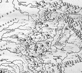
| Mappa Mineralographica | |
|---|---|
| Artiste | |
| Titre |
Mappa Mineralographica |
| Description |
English: Mining map of Northern Transylvania (Romania). Published in the 1726 work Danubius Pannonico-Mysicus, vol. 2 by the Italian naturalist and soldier Luigi Ferdinando Marsigli (1658 – 1730).
Ce fichier a été téléversé avec Commonist. |
| Date | 1726 |
| Source / photographe | Morarescu, Codrea (2011) - Informatii mineralogice din secolul 18 dupa Marsigli, Studii si comunicari DIS, vol IV at Romanian Committee for History and Philosophy of Science and Technology, part of Romanian Academy |
| Autres versions |
|

| Luigi Ferdinando Marsigli : Danubius Pannonico-Mysicus | |||||||||||||||||||||||||||||||||||||||||||||||||||||
|---|---|---|---|---|---|---|---|---|---|---|---|---|---|---|---|---|---|---|---|---|---|---|---|---|---|---|---|---|---|---|---|---|---|---|---|---|---|---|---|---|---|---|---|---|---|---|---|---|---|---|---|---|---|
| Auteur |
|
 | |||||||||||||||||||||||||||||||||||||||||||||||||||
| Illustrateur |
|
||||||||||||||||||||||||||||||||||||||||||||||||||||
| Titre | |||||||||||||||||||||||||||||||||||||||||||||||||||||
| Sous-titre | Observationibus geographicis, astronomicis, hydrographicis, historicis, physicis perlustratus | ||||||||||||||||||||||||||||||||||||||||||||||||||||
| Volume | 1–6 | ||||||||||||||||||||||||||||||||||||||||||||||||||||
| Éditeur de publication | |||||||||||||||||||||||||||||||||||||||||||||||||||||
| Description |
English: 1726 work by the Italian naturalist and soldier Luigi Ferdinando Marsigli (1658 – 1730). It is a natural history encyclopedia of the lower Danube, published in 6 volumes in both The Hague and Amsterdam. The extensive work covers cartography (vol. 1), classical studies (vol. 2), mineralogy (vol. 3), fish fauna (vol. 4), birds (vol. 5) and other subjects (vol. 6).
Detailed information by volumes:
|
||||||||||||||||||||||||||||||||||||||||||||||||||||
| Langue | latin | ||||||||||||||||||||||||||||||||||||||||||||||||||||
| Date de publication | 1726 | ||||||||||||||||||||||||||||||||||||||||||||||||||||
| Lieu de publication | The Hague and Amsterdam | ||||||||||||||||||||||||||||||||||||||||||||||||||||
| Source | Various, see individual images/pages | ||||||||||||||||||||||||||||||||||||||||||||||||||||
| Autorisation (Réutilisation de ce fichier) |
|
||||||||||||||||||||||||||||||||||||||||||||||||||||


Conditions d’utilisation
|
Cette œuvre est également dans le domaine public dans tous les pays pour lesquels le droit d’auteur a une durée de vie de 100 ans ou moins après la mort de l’auteur. | |
| Ce fichier a été identifié comme étant exempt de restrictions connues liées au droit d’auteur, y compris tous les droits connexes et voisins. | |
Historique du fichier
Cliquer sur une date et heure pour voir le fichier tel qu'il était à ce moment-là.
| Date et heure | Vignette | Dimensions | Utilisateur | Commentaire | |
|---|---|---|---|---|---|
| actuel | 18 décembre 2011 à 01:53 | | 869 × 774 (413 kio) | Codrinb |
Utilisation du fichier
Aucune page n’utilise ce fichier.
Usage global du fichier
Les autres wikis suivants utilisent ce fichier :
- Utilisation sur en.wikipedia.org
- Utilisation sur ja.wikipedia.org
- Utilisation sur sr.wikipedia.org