Fichier:Mars landing sites 2014.jpg

Taille de cet aperçu : 800 × 400 pixels. Autres résolutions : 320 × 160 pixels | 640 × 320 pixels | 1 280 × 640 pixels.
Fichier d’origine (1 280 × 640 pixels, taille du fichier : 1,02 Mio, type MIME : image/jpeg)
Ce fichier et sa description proviennent de Wikimedia Commons.
Description
| Description |
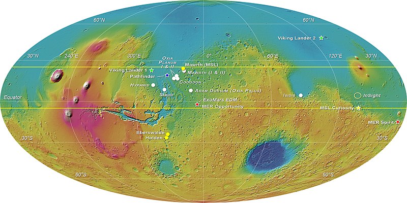
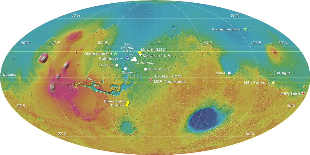
English: MOLA elevation map of Mars with white circles showing the eight landing sites proposed for the ExoMars 2018 mission: Mawrth Vallis (for which 2 proposals were received), Oxia Planum (2 areas were proposed), Coogoon Valles, Hypanis Vallis, Simud Vallis, Oxia Palus and Southern Isidis.
A yellow star marks the position of the Curiosity rover; three other locations that were shortlisted for Curiosity are indicated with yellow circles. Other stars and ellipses are used to indicate past and future missions' touchdown spots. This image was compiled by E. Hauber for the Landing Site Selection Working Group. |
| Date | |
| Source | http://mars.nasa.gov/multimedia/images/?ImageID=6125 > File |
| Auteur | ESA-Roscosmos/LSSWG/E. Hauber |
Conditions d’utilisation
| Ce fichier provient de la NASA. Sauf exception, les documents créés par la NASA ne sont pas soumis à copyright. Pour plus d'informations, voir la politique de copyright de la NASA. | ||
 |
Attention :
|
Historique du fichier
Cliquer sur une date et heure pour voir le fichier tel qu'il était à ce moment-là.
| Date et heure | Vignette | Dimensions | Utilisateur | Commentaire | |
|---|---|---|---|---|---|
| actuel | 25 novembre 2021 à 05:54 | | 1 280 × 640 (1,02 Mio) | Cherurbino | updated version as of 1 September 2019 from https://exploration.esa.int/web/mars/-/53942-exomars-2018-proposed-landing-sites |
| 10 mars 2016 à 19:13 |  | 1 024 × 512 (114 kio) | BatteryIncluded | User created page with UploadWizard |
Utilisation du fichier
La page suivante utilise ce fichier :
Usage global du fichier
Les autres wikis suivants utilisent ce fichier :
- Utilisation sur ca.wikipedia.org
- Utilisation sur cs.wikipedia.org
- Utilisation sur en.wikipedia.org
- Utilisation sur et.wikipedia.org
- Utilisation sur gl.wikipedia.org
- Utilisation sur it.wikipedia.org
- Utilisation sur li.wikipedia.org