Fichier:Map of the Allied landings at Arawe on 15 December 1943.jpg

Taille de cet aperçu : 800 × 550 pixels. Autres résolutions : 320 × 220 pixels | 640 × 440 pixels | 1 024 × 704 pixels | 1 161 × 798 pixels.
Fichier d’origine (1 161 × 798 pixels, taille du fichier : 162 kio, type MIME : image/jpeg)
Ce fichier et sa description proviennent de Wikimedia Commons.
Description
| Description |
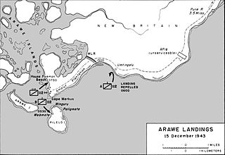
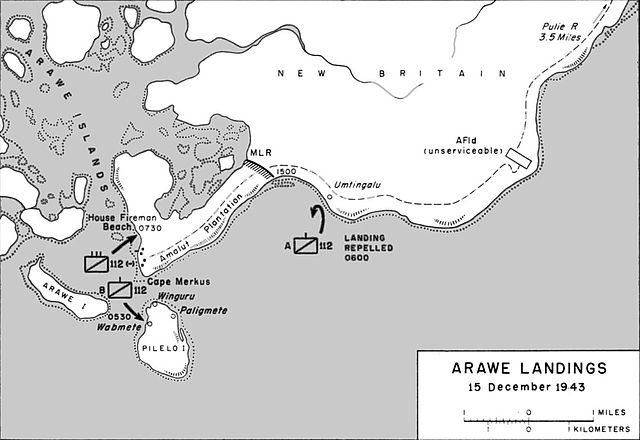
English: Map of the Allied landings in the Arawe area of New Britain on 15 December 1943 |
| Date | |
| Source | United States Army in World War II, The War in the Pacific. CARTWHEEL: The Reduction of Rabaul http://www.ibiblio.org/hyperwar/USA/USA-P-Rabaul/USA-P-Rabaul-14.html |
| Auteur | F. Temple |
Conditions d’utilisation
Ce média est dans le domaine public des États-Unis d’Amérique car son auteur est l’administration américaine comme précisé dans le code fédéral au Titre 17, Chapitre 1, Section 105. Pour en savoir plus : droit d’auteur.
Attention : Ceci ne concerne que le travail du Gouvernement Fédéral et pas celui des États, ou d’une autre subdivision géographique ou politique du pays.
|
 | |
| Ce fichier a été identifié comme étant exempt de restrictions connues liées au droit d’auteur, y compris tous les droits connexes et voisins. | ||
Historique du fichier
Cliquer sur une date et heure pour voir le fichier tel qu'il était à ce moment-là.
| Date et heure | Vignette | Dimensions | Utilisateur | Commentaire | |
|---|---|---|---|---|---|
| actuel | 20 février 2017 à 21:16 | | 1 161 × 798 (162 kio) | Macesito | Cropped |
| 29 janvier 2012 à 01:02 |  | 1 163 × 822 (142 kio) | Nick-D | {{Information |Description ={{en|1=Map of the Allied landings in the Arawe area of New Britain on 15 December 1943}} |Source = United States Army in World War II, The War in the Pacific. CARTWHEEL: The Reduction of Rabaul http://www.ibiblio.org |
Utilisation du fichier
La page suivante utilise ce fichier :
Usage global du fichier
Les autres wikis suivants utilisent ce fichier :
- Utilisation sur de.wikipedia.org
- Utilisation sur en.wikipedia.org
- Utilisation sur es.wikipedia.org
- Utilisation sur fi.wikipedia.org
- Utilisation sur hu.wikipedia.org