Fichier:Map of Montreal (1758) by Thomas Jefferys.jpg

Fichier d’origine (8 251 × 5 346 pixels, taille du fichier : 9,94 Mio, type MIME : image/jpeg)
Ce fichier et sa description proviennent de Wikimedia Commons.
_by_Thomas_Jefferys.jpg?uselang=fr)
Description
| Description |
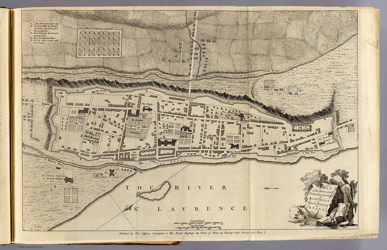
Français : Plan de Montréal en 1758, par Thomas Jefferys. |
| Date | |
| Source | http://www.davidrumsey.com/luna/servlet/detail/RUMSEY~8~1~29568~1141031:Plan-of-the-town-and-fortifications# |
| Auteur |
Jefferys, Thomas Date:1758 Publication Author:Jefferys, Thomas Pub Date:1760 |
Jefferys, Thomas Date: 1758 Short Title: Montreal or Ville Marie. Publisher: Thomas Jefferys Publisher Location: London Type: Book Map Obj Height cm: 34 Obj Width cm: 51 Scale 1: 3,300 Note: Engraved map. Shows buildings, fields, etc. Oriented with north toward upper right. Reference: Phillips. Maps of America, p. 450; Cf. LC Maps of North America, 619. State/Province: Quebec City: Montreal (Quebec) Full Title: Plan of the town and fortifications of Montreal or Ville Marie in Canada. Published by Thos. Jefferys, Geographer to His Royal Highness the Prince of Wales at Charing Cross, Jan 30, 1758. Price 2s. (1760) List No: 4796.003 Page No: (pt. 1, opp. p. 12) Series No: 5 Publication Author: Jefferys, Thomas Pub Date: 1760 Pub Title: The natural and civil history of the French dominions in North and South America. Giving a particular account of the climate, soil, minerals, animals, vegetables, manufactures, trade, commerce, and languages ... Illustrated by maps and plans of the principal places, collected from the best authorities, and engraved by T. Jefferys, Geographer to his Royal Highness the Prince of Wales. Part I. Containing a description of Canada and Louisiana. London, Printed for Thomas Jefferys at Charing-Cross. MDCCLX. Pub Reference: Howes J83; Streeter 128; Sabin 35964; P-Maps (lists all 18 maps); Stevens and Tree 27(b), 51(a), 66 (b); Clark I:263; Ristow p25-28 (Samuel Holland). Pub Note: See note field above. Pub List No: 4796.000 Pub Type: Geography Book Pub Maps: 18 Pub Height cm: 36 Pub Width cm: 23 Image No: 4796003 Download 1: Full Image Download… Download 2: GeoViewer for JP2 a… Collection: Rumsey Collection
| Thomas Jefferys
(1719–1771) |
|||
|---|---|---|---|
| Autres noms |
Thomas Gefferys, Thomas Jefferies, Thomas Jeffreys | ||
| Description | cartographe et géographe anglais | ||
| Date de naissance / décès | vers 1719 |
20 novembre 1771 | |
| Lieu de naissance / décès | Angleterre | Londres | |
| Lieu de travail | |||
| Autorité | |||
Conditions d’utilisation
|
Cette œuvre est également dans le domaine public dans tous les pays pour lesquels le droit d’auteur a une durée de vie de 70 ans ou moins après la mort de l’auteur. Cette œuvre est dans le domaine public aux États-Unis car elle a été publiée avant le 1er janvier 1929. | |
| Ce fichier a été identifié comme étant exempt de restrictions connues liées au droit d’auteur, y compris tous les droits connexes et voisins. | |
Historique du fichier
Cliquer sur une date et heure pour voir le fichier tel qu'il était à ce moment-là.
| Date et heure | Vignette | Dimensions | Utilisateur | Commentaire | |
|---|---|---|---|---|---|
| actuel | 5 décembre 2016 à 04:23 | | 8 251 × 5 346 (9,94 Mio) | Pierre5018 | User created page with UploadWizard |
Utilisation du fichier
Les 3 pages suivantes utilisent ce fichier :
_by_Thomas_Jefferys.jpg)