Fichier:Map of Illinois highlighting counties without township government.svg

Taille de cet aperçu PNG pour ce fichier SVG : 187 × 337 pixels. Autres résolutions : 133 × 240 pixels | 266 × 480 pixels | 426 × 768 pixels | 568 × 1 024 pixels | 1 136 × 2 048 pixels.
Fichier d’origine (Fichier SVG, nominalement de 187 × 337 pixels, taille : 36 kio)
Ce fichier et sa description proviennent de Wikimedia Commons.
Description
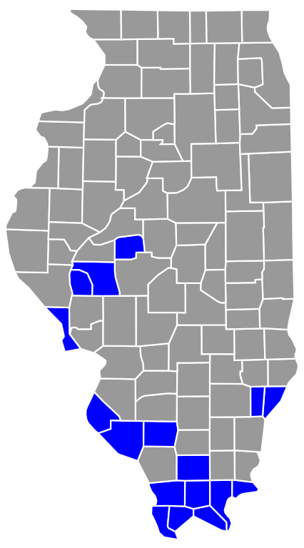
| Description | This is a map highlighting Illinois counties without township government (Precincts not townships). |
| Date | |
| Source | Travail personnel |
| Auteur | Travail personnel Derived from David Benbennick's map. For more information, see Commons:United States county locator maps. |
| SVG information | Le code de ce fichier SVG n'est pas valide en raison d'une erreur. Cette carte W3C-invalide a été créée avec un logiciel SVG inconnu |
Conditions d’utilisation
| Moi, propriétaire des droits d’auteur sur cette œuvre, la place dans le domaine public. Ceci s'applique dans le monde entier. Dans certains pays, ceci peut ne pas être possible ; dans ce cas : J’accorde à toute personne le droit d’utiliser cette œuvre dans n’importe quel but, sans aucune condition, sauf celles requises par la loi. |
Historique du fichier
Cliquer sur une date et heure pour voir le fichier tel qu'il était à ce moment-là.
| Date et heure | Vignette | Dimensions | Utilisateur | Commentaire | |
|---|---|---|---|---|---|
| actuel | 23 janvier 2021 à 05:49 | | 187 × 337 (36 kio) | Elli | Use a different map base that distinguishes between adjacent counties. |
| 19 avril 2013 à 22:48 |  | 3 453 × 6 157 (84 kio) | Dewclouds | Fixed typo in source to add Randolph County. | |
| 24 février 2007 à 20:58 |  | 3 453 × 6 157 (84 kio) | Dual Freq | This is a map highlighting Illinois counties without township government (Precincts not townships). Modification of David Benbennick's map. For more information, see Commons:United States county locator maps. {{PD-self}} [[Categor |
Utilisation du fichier
Les 2 pages suivantes utilisent ce fichier :
Usage global du fichier
Les autres wikis suivants utilisent ce fichier :
- Utilisation sur en.wikipedia.org
- Utilisation sur ro.wikipedia.org